

Forecast for the Uintas Area Mountains

Issued by Craig Gordon on
Sunday morning, December 18, 2022
Sunday morning, December 18, 2022
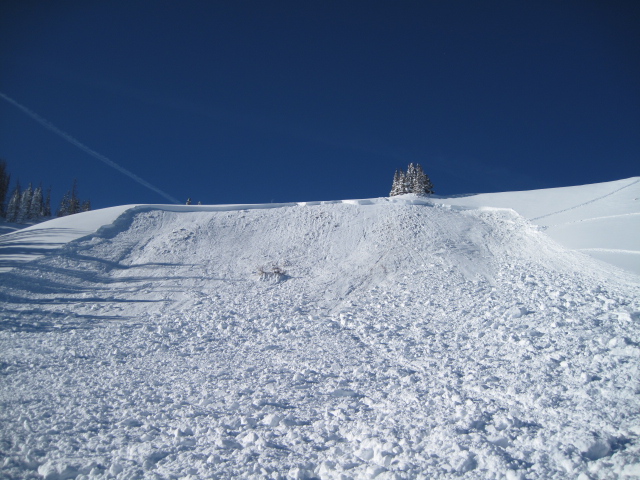
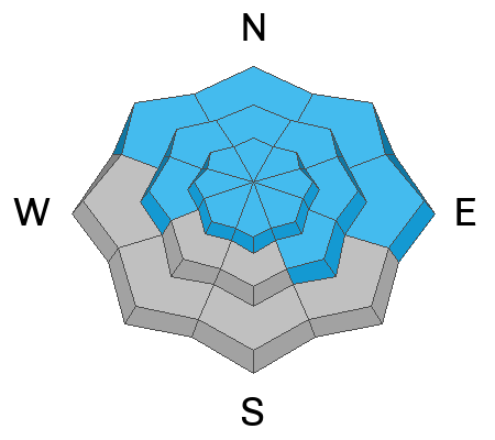
DECEPTIVELY DANGEROUS AVALANCHE CONDITIONS LINGER. Today, you'll find CONSIDERABLE avalanche danger on all steep, shady slopes. The danger is most pronounced in terrain facing the north half of the compass in the wind zone at and above treeline. Human triggered avalanches breaking to weak, sugary, midpack snow are LIKELY. Mid elevation slopes on the south half of the compass with similar layering offer MODERATE avalanche danger and human triggered avalanches are POSSIBLE.
Looking for LOW avalanche danger? Well then, simply steer yourself toward low elevation south facing slopes, or head to wind sheltered terrain with no overhead hazard (meaning, no steep slopes above or adjacent to where I'm traveling) is the hot ticket. I've been finding excellent riding conditions and fun meadow skipping on mellow, wind sheltered slopes with no overhead hazard.
Low
Moderate
Considerable
High
Extreme
Learn how to read the forecast here
Special Avalanche Bulletin
Dangerous and unusual avalanche conditions will last through the weekend. Heavy snowfall this past week created dangerous avalanche conditions at all elevations. Don’t be lured by the beautiful sunny skies and fresh powder into thinking avalanche conditions are safe... they are not!
Do not travel on, underneath, or adjacent to slopes 30 degrees or steeper on slopes facing northwest, north, northeast, and east where triggering large and dangerous avalanches is likely. This includes low-elevation foothills where avalanches can occur not far from parking areas and trailheads.
 Special Announcements
Huge thanks all our local heroes, the hard working gals and guys who have given so much of themselves this week to save the lives of two very lucky backcountry riders. I am honored to know you and we are all grateful for your dedication and service!
We have dodged a few bullets with two close calls in the backcountry Tuesday and Wednesday. One in Pink Pine the other in Neff's Canyon.
Both Mirror Lake Highway and Wolf Creek Pass are closed for the season
 Weather and Snow
Nowcast- As a slightly warmer airmass settles in over the region, temperatures claw their way out of negative territory and currently register in the single digits and low teens. Winds switched to the southwest before the turn of the new day but remain rather well-behaved, blowing just 10-20 mph even along the high ridges. The Inspired Summit Adventure Crew reports all-time riding and notes from an avy class in the Wolf Creek zone.... "Remarkably calm winds on the pass today. No visible transport and trees still dressed in white holding on to the entirety of the storm snow." Yep, it's mid December and the riding and turning conditions are remarkable!
Forecast- A dry northwest flow delivers sunny skies, light winds, and temperatures climbing into the mid 20's.
Futurecast- A chance for snow arrives midweek, but the jury is still deliberating on timing and strength.
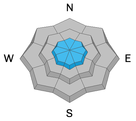
KA-POW!
This weeks storm totals register close to 24" of snow with just about 1.5" of H2O. In other words... over-the-hood and over-the head!
Lots of excellent trip reports and recent obs are found HERE.
 Recent Avalanches
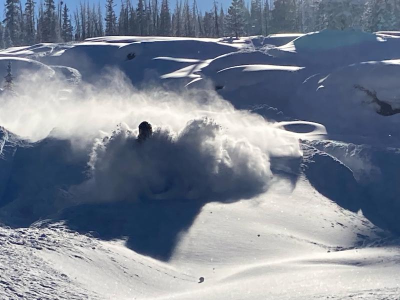
Even though they're in different parts of the range, recent human triggered avalanches display similar characteristics, revealing a failure in the midpack weakness which leads to avalanches gouging to the ground-
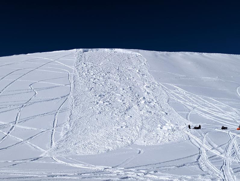
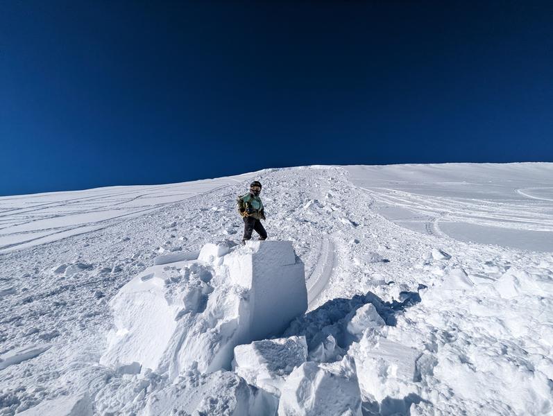
Yesterday, Joey Manship rolled up the this freshly triggered avalanche on the south half of the range near Tower Mountain. Yeah, getting pinned under the debris could easily ruin your day. More info HERE
Meanwhile, Ted took a look at a sled triggered slide from Friday on the North Slope near Humpy Peak and has an outstanding writeup found HERE.
Recent avy activity and a slew of Uinta obs are HERE.

Avalanche Problem #1
Persistent Weak Layer
Type
Location
Likelihood
Size
Description
Here's where the rubber meets the road. The biggest clue to avalanches is... avalanches! Mark remotely triggering this piece of snow yesterday confirms all our snowpack suspicions... the fragile, sugary, and persistent weak layer (PWL) in the mid portion of our snowpack is still quite reactive to our additional weight.
At o'dark thirty, I'm asking myself, is it dangerous out there... will I trigger an avalanche today... can I even ride today? Yes, yes, and yes! But let's strip it down, keep it simple, and you don't need a Ouija board to figure it out. In fact, the formula is rather straight-forward-
It's dangerous if you choose steep slopes, especially those facing the north half of the compass.
The most likely place to trigger an avalanche is where a dense, strong, solid layer (slab) rests on weaker snow (Persistent Weak Layer or PWL) formed during the mid November dry-spell. That combo is found on slopes facing the north half of the compass, especially those in the wind zone at and above treeline.
But most importantly, I wanna know where I can ride and NOT trigger an avalanche. And actually that's an easy one. The powder is light, travel is easy on a very supportable base, and low angle terrain rides like a dream!
So... with no shortage of great riding in big open meadows and on low angle slopes there's plenty of opportunity to avoid pulling on the avalanches dragons tail all together.
I'm no sooth-sayer (more the Shaman type :) but I know in time our current instabilities will relax and the snow will slowly gain strength. I also know it's time to pump the brakes, continue practicing some patience, and allow the snow the adjust to the recent big storm.
Avalanche Problem #2
Wind Drifted Snow
Type
Location
Likelihood
Size
Description
While not widespread, today you'll find a few lingering shallow, yet sensitive drifts along the leeward side of ridges and around terrain features like chutes and gullies.
But wait, there's more... once initiated, a seemingly harmless shallow drift can get quickly out of hand if it breaks to older, weaker, midpack snow. Found mostly on the leeward side of upper elevation ridges, I'd also be on the look out for drifting around terrain features like chutes and gullies. In either case, you'll wanna look for and avoid any fat looking rounded pillow of snow, especially if it sounds hollow like a drum.
Hot ticket and where to ride-
Easily managed and avoided with terrain choices... lose the wind, you lose the problem, and score great riding conditions to boot. Done, done, and done :)
Additional Information
And... we were super busy this summer upgrading the western Uinta weather station network and this real-time winter info is found HERE (click weather stations, and then on the Western Uinta tab)
Your observations are important, so please let me know what you're seeing... click HERE and contribute to this amazing community-based program
General Announcements
Issued at 03:56 on Sunday December 18th, this forecast expires 24 hours after the date and time posted, but will be updated by 07:00 Monday December 19th.
Before it gets too crazy, now is the time to book an avalanche awareness presentation for your group, club, or posse. You can reach Craig directly at 801-231-2170 or [email protected].
This forecast is from the U.S.D.A. Forest Service, which is solely responsible for its content. This forecast describes general avalanche conditions and local variations always occur.