

Forecast for the Uintas Area Mountains

Issued by Craig Gordon for
Sunday, January 2, 2022
Sunday, January 2, 2022
Please don't let fresh snow and sunny skies play into your decision making... AVALANCHE CONDITIONS REMAIN DECEPTIVELY TRICKY
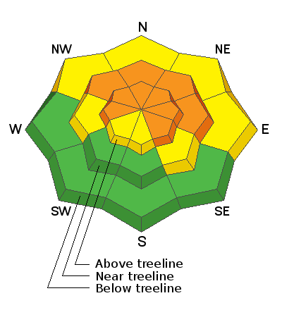
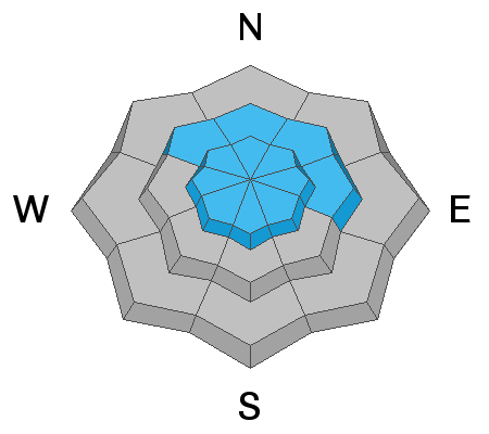
Near and above treeline, especially in the wind zone, the avalanche danger is CONSIDERABLE. Triggering a deep, dangerous avalanche is LIKELY, particularly on steep, wind drifted slopes facing the north half of the compass.
Look for MODERATE avalanche danger below treeline where human triggered avalanches are possible on steep, shady slopes.
What to do and where to go... what's your exit strategy? The Uintas are blessed with open meadows and rolling terrain that isn't steep enough to produce avalanches. Practice your riding technique and rip deep trenches in a big open meadow today, or head to low angle, sunny slopes that didn't have old October snow for some fun turns in the sun. But remember- let's give the steep, shady slopes some time to get comfortable in their new winter coats.
Low
Moderate
Considerable
High
Extreme
Learn how to read the forecast here
 Weather and Snow
NOWCAST-
Skies cleared overnight and temperatures cratered with most locations reporting diesel gelling cold in the single digits and negative territory. Northerly winds blow 25-35 mph along the high peaks, delivering windchill to -20 degrees. Seven day storm totals nearing 70" produce riding and turning conditions that are all time and in short order, I bet you forget about the cold.
FORECAST-
Look for mostly sunny skies and a steady crawl out of the deep freeze with high temperatures cracking into the low 20's. Winds switch to the west and southwest throughout the day, blowing in the 20's and 30's along the high ridges.
FUTURECAST-
Slightly warmer temperatures are on tap for Monday, with another storm sliding into the region Tuesday. We're in it to win it... an active pattern is in the queue for the remainder of the week.
Snowfall numbers over the last week are impressive and a major red flag. Here are the water numbers since December 23 from SNOTEL sites. As a general rule of thumb one inch of water equates to 12 inches of snow.
North Slope to Mirror Lake Hwy-
Chalk Creek - 5.4" H2O
Hayden Fork - 4.3" H2O
Trial Lake - 7.2" H2O
South half of the range-
Currant Creek - 5.7" H2O
Daniels-Strawberry - 5.5" H2O
Looking for real-time temps, snow, or wind?
Click HERE and then on the "western Uinta" tab for western Uinta specific, weather station network.
 Recent Avalanches
I'm happy to report no close calls or significant human triggered slides to report from a very busy Saturday.... thanks for that!
With a keen eye you can spot remnants of natural avalanche activity that occurred during the big storm cycle.
Click HERE for a list of recent avalanches.
A list of all other observations is found HERE
Your input is vital and we're interested in what you're seeing. Please contribute to this great community resource and go here to fill out an observation.

Avalanche Problem #1
Persistent Weak Layer
Type
Location

Likelihood
Size
Description
Mark offers some great advice on how to enjoy all this amazing snow
A persistent weak layer (PWL) of faceted snow near the ground will produce hard and soft slab avalanches today. Dense snowfall and strong winds in December created a very stiff slab on top of this weak layer. The good news is that it is very supportable. The bad news is that:
- Once triggered, avalanches may break hundreds of feet wide.
- It may not be the first person on a slope that triggers A LARGE, DANGEROUS avalanche, it may be the second, third, fourth, etc. who triggers it.
- Seeing tracks on a slope DOES NOT mean it's safe.
PWL exists on any slope that harbored old October snow, which grew and sugary during the November dry spell. Most low elevations slopes and south-facing slopes don't have this layer.
Slopes loaded by south winds are the exact ones where this weak layer exists. The addition of wind-drifted snow will make avalanches even larger, deeper, and more deadly.

Ted was on the east side of the range where he experienced collapsing and strong snow over weak snow... JG was in the Weber Canyon snowbelt and found a much stronger pack.
Avalanche Problem #2
Wind Drifted Snow
Type
Location
Likelihood
Size
Description
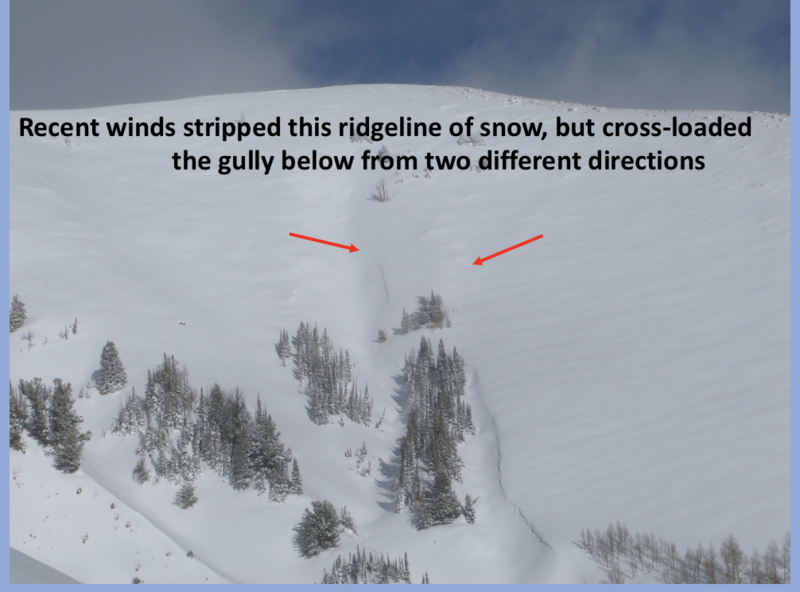
Yesterday and overnight, northerly winds created fresh drifts along the leeward of upper elevation ridges, but those should be rather manageable and easy to avoid by losing a little elevation. However, more concerning are the old drifts formed during and after the big Christmas storm. Remember... southerly winds cranked in the 50's and 60's for nearly a week as the storm decided to make landfall. With no shortage of snow available to blow around, wind drifts formed nearly everywhere and at all elevations, not just along the leeward side of upper elevation ridges. Now here's the tricky part... both new and old drifts are hidden under a blanket of light, fluffy snow, making them hard to detect. So let's keep this simple. Today, we simply need to stay off of any steep, wind drifted slope, especially if the snow looks fat and rounded, or sounds hollow like a drum.
Additional Information
What a way to ring in the NEW YEAR!
Your observations are important, so please let me know what you're seeing... click HERE and contribute to this amazing community based program
General Announcements
The information in this forecast expires 24 hours after the day and time posted, but will be updated by 07:00 Monday January 3rd.
Before it gets too crazy, now is the time to book an avalanche awareness presentation for your group, club, or posse. You can reach me directly at 801-231-2170 or [email protected]
This forecast is from the U.S.D.A. Forest Service, which is solely responsible for its content. This forecast describes general avalanche conditions and local variations always occur.