Forecast for the Salt Lake Area Mountains

Greg Gagne
Issued by Greg Gagne for
Friday, April 12, 2019
The avalanche hazard is generally Low, but there are enough concerns - especially with unpredictable spring weather - that warrant an overall Moderate hazard. The primary avalanche issues include recent storm snow as well as recent and new wind drifts. Additionally, if the snow surface warms today, avalanches involving wet snow are possible. Have a flexible plan that allows you to quickly respond to changing conditions.
Low
Moderate
Considerable
High
Extreme
Learn how to read the forecast here
Special Announcements
Daily early morning avalanche forecasts will end Sunday, April 14. We will issue early morning forecasts on Friday, Saturday, and Sunday of Easter weekend (April 19-21). Throughout the rest of April, we will issue intermittent updates with any snowfall or other significant weather events, and we will continue posting observations.
Drew Hardesty just penned another wonderful blog piece, Meditations on Skiing the No-Fall Zone.
Our final podcast for the season has been released HERE. Low Danger - A Story in 5 Parts. Thanks much to our producer Benjamin Bombard and our sponsors Arva, Prival, and 2nd Tracks Sports.
Weather and Snow
Skies are overcast and mountain temperatures are in the teens. Northwest winds increased for a 4-6 hour period late yesterday afternoon and into the evening, with gusts in the 20’s and 30’s mph along upper elevation ridges, but have since relaxed, and are now light and < 10 mph.
In the winter that continues to provide, many mountain locations picked up several inches of snow late yesterday afternoon, with storm totals since Wednesday of over 3’ in upper Little Cottonwood, 2’ in Big Cottonwood, and 12-18” along the Park City ridgeline. Riding conditions are brilliant.
For today, expect temperatures to rise into the 20's and low 30's F. Winds will be out of the northwest, and generally light, with gusts in the teens. Snow showers are possible throughout the day, with isolated areas picking up 2-3" of new snow. Skies should remain mostly-cloudy, and thunder is possible, especially during the afternoon.
Recent Avalanches
Most backcountry observations from Thursday reported a generally stable snowpack. However, one slide that caught my attention was in Mineral Fork on the northeast-facing run GB No that failed 18” down on a density inversion. This slide was 150’ wide, and ran 500’ vertical - observation. Other slides from Thursday include Scottie's Bowl (observation) which may have also run on the density inversion, possibly stepping down to the old, crusted surface. A smaller slide was also reported from Butler Basin (observation).
Be sure to read our Week in Review as you make plans for today and this weekend:
Ad
Avalanche Problem #1
Normal Caution
Type
Location
Likelihood
Size
Description
The chance of triggering an avalanche today is generally Low, but there are enough concerns, especially with unpredictable spring weather, that warrant your careful attention today:
Wind Drifted Snow - Yesterday, my partner and I (observation) were finding isolated pockets of fresh wind drifts that were generally unreactive to ski cuts. But the 4-6 hour window of northwest winds last evening may have created additional pockets of fresh wind drifts which may be reactive today. You are most likely to find any recent wind drifts along upper elevation ridges, especially on any aspects facing north, through east, and south. These drifts may be up to 12-18" deep.
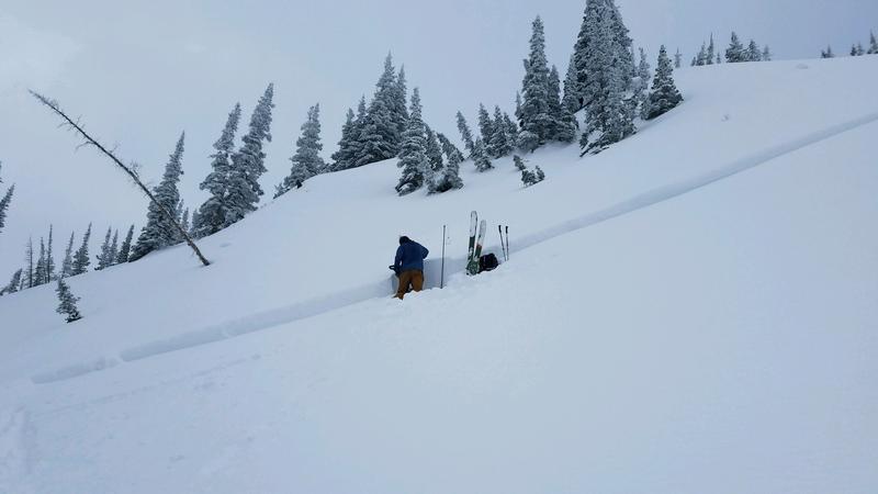
New Snow - The 2-3' of storm snow has settled into a dense, cohesive slab, and it has bonded well to the old snow surface. On Wednesday, several observers were finding the weakest snow to be a density inversion which can now be found about 12-18" down into the storm snow. Although most observations now indicate this density inversion has settled out, yesterday's skier-triggered slide in Mineral Fork (photo below pic:Torrey/Hawley) is a reminder this layer may still be reactive in isolated areas. Finally, lthough any new snow amounts today are likely to be small, sluffing in storm snow is possible during any extended period of heavy precipitation.
Wet Snow - Clouds, cool temperatures, and snow showers should prevent wet activity today, but if the sun peeks out for any extended period or you notice greenhousing (where clouds trap warmer temperatures), you can expect the storm snow to quickly become reactive. This includes both wet loose sluffs as well as larger wet slabs. I would be especially aware of this problem on steep sunny aspects as well as all aspects at lower elevations. Watch for rapid changes in the snow surface such as rollerballs, and have an exit plan that allows you to quickly respond to wet snow activity.
Finally, although several glide avalanche paths have already run, rain and warm temperatures earlier this week may have added the necessary ingredients for further glide avalanche activity. Common places to find glide avalanches are Broads Fork, Stairs Gulch, and Mill B South, and upper Raymond Slabs in upper Porter Fork. Of all the different avalanche problems, glide avalanches are the most difficult to forecast as they can avalanche seemingly random times. With an abundant snowpack throughout the range providing plenty of options, the solution to this problem is pretty easy, and I personally am simply avoiding terrain that involves the risk of glide avalanches. Problem solved.
Additional Information
Spring is here and it is time to adjust our travel. Learn what to watch for during spring avalanche conditions when the snow becomes wet.
General Announcements
This information does not apply to developed ski areas or highways where avalanche control is normally done. This forecast is from the U.S.D.A. Forest Service, which is solely responsible for its content. This forecast describes general avalanche conditions and local variations always occur.