Forecast for the Salt Lake Area Mountains

Mark Staples
Issued by Mark Staples for
Saturday, April 13, 2019
The main avalanche problem today will be wet snow avalanches as strong sunshine heats up new snow from this week making the avalanche danger MODERATE.

Better stability and better riding conditions will be found on northerly aspects where dry snow should remain through the day and the danger is LOW. However, recent avalanche activity in the new snow tells us that a small chance remains for dry snow avalanches. These instabilities are most likely lingering on slopes with wind drifted snow.
Low
Moderate
Considerable
High
Extreme
Learn how to read the forecast here
Special Announcements
Daily early morning avalanche forecasts will end tomorrow, Sunday, April 14. We will issue early morning forecasts on Friday, Saturday, and Sunday of Easter weekend (April 19-21). Throughout the rest of April, we will issue intermittent updates with any snowfall or other significant weather events, and we will continue posting observations.

Drew Hardesty just penned another wonderful blog piece, Meditations on Skiing the No-Fall Zone.
Our final podcast for the season has been released HERE. Low Danger - A Story in 5 Parts. Thanks much to our producer Benjamin Bombard and our sponsors Arva, Prival, and 2nd Tracks Sports.
Weather and Snow
Yesterday: Cloudy skies and snow showers kept things from heating up too much. Across most elevations high temperatures were in the low 30s F. Winds were light. A few inches of snow accumulated yesterday morning followed by another inch or so in the afternoon.
This morning: Mostly clear skies allowed temperatures to drop into the mid to upper teens F. Westerly winds this morning are averaging 5-10 mph with 20 mph gusts at the highest elevations. A band of precipitation moved over Salt Lake City at about 3 a.m. and dropped 2 inches of snow in the mountains.
Today: Clouds should dissipate this morning and there should be more and more sunshine appearing through the day. Temperatures should warm more than yesterday and easily climb into the low 30s to low 40s F depending on elevation. A brief ridge of high pressure will build today, but a series of storms is headed our way starting tomorrow with strong southwest winds.
With cloudy skies and relatively cold weather for this time of year, most slopes have great powder this morning but that should change as the sun heats up many slopes today. Notherly facing slopes should have great powder all day.
Recent Avalanches
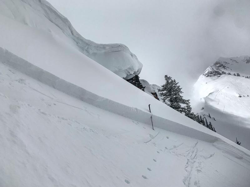
There have been a few avalanches within the new snow. Yesterday ski patrols in the Cottonwood Canyons were still able to trigger a few soft slabs in the new snow up to 30 inches deep. There were three avalanches reported in the backcountry.
  • One occurred on Mt Superior (about 6 inches deep).
  • Another nearby on Cardiff Peak (about 18 inches deep) - photo below by M. White.
  • Another in the Y Couloir (possibly a dry, loose snow slide or sluff).
There were a few other slides breaking with in the new snow on Thursday (Mineral Fork, Scottie's Bowl, and Butler Basin).
All of these slides appear to be breaking within the new snow where slightly denser snow is resting on softer snow.

Be sure to read our Week in Review as you make plans for today and this weekend.
Ad
Avalanche Problem #1
Wet Snow
Type
Location
Likelihood
Size
Description
Skies should clear today and allow strong sunshine to quickly warm the new snow. As this happens wet loose avalanches should occur. The best strategy will be to move to slopes facing northerly where better riding conditions will be found as well.
Wet slab avalanches are also possible. These are difficult to predict but could break up to 2 feet deep as the new snow heats up. I'm not really sure if wet slabs will happen or not, but I know the new snow will be warming quickly. I'd stay on northerly aspects with dry snow today.

A separate but related avalanche problem, is glide avalanches. I'm including them under this category to simplify things. When they happen is mostly unpredictable. Several occurred early this week during rain and warm temperatures. Where they happen is generally predictable because there is often a huge crack in the snowpack. Common places to find glide avalanches are places with rock slabs or a smooth ground surface like Broads Fork, Stairs Gulch, and Mill B South, and upper Raymond Slabs in upper Porter Fork. Simply avoid being under these places or any slope with a visible glide crack.
Avalanche Problem #2
Wind Drifted Snow
Type
Location
Likelihood
Size
Description
The new snow that fell this week is generally well bonded and stable. However there have been a few avalanches in the new snow about 12-18 inches deep. I think today any remaining instabilities in the new snow will be in isolated spots with wind drifted snow.
Additional Information
Spring is here and it is time to adjust our travel. Learn what to watch for during spring avalanche conditions when the snow becomes wet.
General Announcements
This information does not apply to developed ski areas or highways where avalanche control is normally done. This forecast is from the U.S.D.A. Forest Service, which is solely responsible for its content. This forecast describes general avalanche conditions and local variations always occur.