Forecast for the Salt Lake Area Mountains

Evelyn Lees
Issued by Evelyn Lees for
Thursday, April 11, 2019
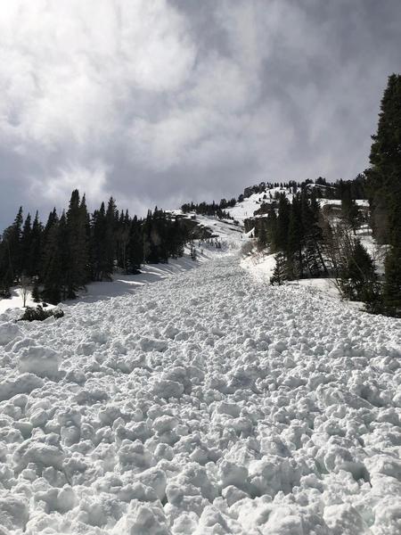
The avalanche danger is CONSIDERABLE on steep, wind drifted mid and upper elevation slopes, where human triggered slides likely today. The danger could rise from LOW to CONSIDERABLE for wet loose sluffs if the clouds thin or the sun comes out. Avoid avalanche runout zones even at the low elevations. Terrain with less than a foot of new snow has a lower danger.
Want a great powder day? Seek wind sheltered slopes early in the day while the snow is cold and the avalanche danger is LOW to MODERATE. It could be a dynamic day, but with careful snowpack evaluation and constant assessment for heating, there are lots of safer options for amazing touring and riding today.
Low
Moderate
Considerable
High
Extreme
Learn how to read the forecast here
Special Announcements
Daily early morning avalanche forecasts will end Sunday, April 14. We will issue early morning forecasts on Friday, Saturday, and Sunday of Easter weekend (April 19-20). Throughout the rest of April, we will issue intermittent updates with any snowfall and we will continue posting observations.

Our final podcast for the season has been released HERE. Low Danger - A Story in 5 Parts. Thanks much to our producer Benjamin Bombard and our sponsors Arva, Prival, and 2nd Tracks Sports.

Thanks so much to everyone who supported our spring fundraiser. We exceeded our goals. The UAC could not exist without your support.
Weather and Snow
What a storm!! Snow totals are 22 to 32 inches in upper elevations of Little Cottonwood, and 12 to 24” in Big Cottonwood, and about 12” settled snow along the higher Park City ridgeline. Temperatures have cooled into the teens and low twenties. Overnight, the northwesterly winds were strong, averaging 15 to 25 mph, with gusts to 40 mph at 10,000’, and averaging 35 to 60 mph, with gusts in the 60s to 70s at 11,000’. Storm water totals are 1.5” to a whopping 4 inches in Little Cottonwood.
Today: Under partly cloudy skies, lake effect snow showers this morning and convective showers this afternoon will produce another 1 to 4” of snow. This morning’s brisk northwesterly winds should slowly decrease, though averages of 20 to 30 mph, with gusts to 40 mph will still occur at 10,000’ and the highest peaks could average 35 mph, with gusts in the 50s. Temperatures will warm to near freezing at 8,500’ and into the mid 20s at 10,000’.
Recent Avalanches
Little Cottonwood was the epicenter of the snow and the avalanche activity. The resorts reported ski and explosive triggered slides on all aspects and elevations, large enough to bury a person. In the upper elevation wind zone, a few even larger natural slides occurred. Highway control on south facing slopes released large slides running up to 2000’ vertical in both the morning and afternoon. In Big Cottonwood, explosives triggered 2 slides that gouged into wet snow and one wet slab avalanche.
Backcountry - numerous small skier triggered new snow slides and a few naturals, about 4 to 12" deep and 30 - 100' wide, breaking on a density inversion or in a wind effected area. The closest call was on Kessler Slabs, where the skier managed to stop and avoid the 1000' ride. A few collapses on wet snow were reported.
Cracking of a test slopes at 8,000'. AT photo.
Ad
Avalanche Problem #1
Wind Drifted Snow
Type
Location
Likelihood
Size
Description
While the new snow instabilities from yesterday have mostly strengthened, the drifts of wind blown snow that formed overnight will take a bit longer to heal. While these 1 to 3 foot deep drifts will be most widespread at the highest elevations, drifts can also be found well off ridge lines, at the mid elevations and cross loaded around terrain features. They will be wider and deeper than yesterday’s new snow only slides. Signs of wind drifts include cracking of the snow and looking for and avoiding smooth, rounded pillows of snow.
There will be a whole new batch of cornices along the higher ridge lines, and they may break from a distance. Stay well back from corniced edges when traveling on ridge lines and avoid travel beneath them.
New snow - if there is brief, heavy snowfall where you are, the newest snow could become reactive again, and there could be some graupel pooling below cliffs to avoid.
Avalanche Problem #2
Wet Snow
Type
Location
Likelihood
Size
Description
Today, I am very skeptical that thick cloud cover will hold everywhere. If the sun even thinks about coming out or the clouds thin...the surface snow will almost instantly heat, and wet loose avalanches and shallow wet slabs will become easy to trigger. Thinning of the clouds means the snow will heat on all aspects and elevations except steep, upper elevation northerly facing slopes. Direct sun will heat steep, sunny slopes.
Clues will be abundant if the snow heats - you will feel the hot April sun, the snow becomes sticky or damp, pinwheels or swarms of roller balls race downhill, you’re triggering small sluffs or the snow is falling off rocks and trees. Danger for wet sluffs can rise from LOW to CONSIDERABLE in minutes. Wet avalanche debris piles up instead of spreading out, and even small slides can deposit 4 feet of cement like debris. Get off steep slopes, head to low angle slopes and avoid travel beneath steep slopes and avalanche run out zones. This includes north facing couloirs like the Y. Have a game plan for your exit out of the backcountry.
The old wet snow at the mid and lower elevations should have cooled, but any collapsing is a clue that it is still weak, and steep slopes should be avoided.
Wet debris is dangerous. Monday's natural slide off east facing Kessler. Nina Lorentzen photo.
Avalanche Problem #3
Gliding Snow
Type
Location
Likelihood
Size
Description
Glide avalanches are difficult to forecast as they seem to happen at unpredictable times. A good dose of rain yesterday following a long stretch of above freezing temperatures day and night are prime conditions for these avalanches to occur. Before releasing, the snowpack typically produces large, visible cracks in the snow which tell us where these avalanches can occur.
They often happen where the snowpack rests on top of rock slabs or smooth surfaces. Common places to find these cracks and glide avalanches are Broads Fork, Stairs Gulch, and Mill B South, and upper Raymond Slabs in upper Porter Fork. Knowing when they will occur is very difficult to forecast.
Additional Information
Spring is here and it is time to adjust our travel. Learn what to watch for during spring avalanche conditions when the snow becomes wet.
General Announcements
This information does not apply to developed ski areas or highways where avalanche control is normally done. This forecast is from the U.S.D.A. Forest Service, which is solely responsible for its content. This forecast describes general avalanche conditions and local variations always occur.