Join us for the 33rd Backcountry Benefit - Get Your Tickets Now!

Forecast for the Salt Lake Area Mountains

Nikki Champion
Issued by Nikki Champion on
Sunday morning, March 1, 2026

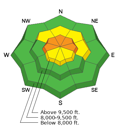
Avalanche danger is CONSIDERABLE on upper-elevation slopes facing west through north to east. Avalanches may be large and destructive, breaking on a buried persistent weak layer 2 to 3+ feet deep and potentially hundreds of feet wide. Sensitive slabs of wind-drifted snow may exist on all aspects at upper elevations.

While the likelihood of triggering an avalanche is slowly decreasing, the consequences remain just as high. Upper-elevation, thinner snowpack areas are most suspect, but weak snow exists at mid and lower elevations as well. Evaluate snow and terrain carefully, make conservative decisions, and avoid slopes steeper than 30 degrees with the poor snowpack structure.

As temperatures rise, wet snow avalanches may become possible, raising danger to MODERATE on all low-elevation and sun-exposed slopes. Avoid steep terrain during the warmest part of the day and watch for changing conditions.

Low
Moderate
Considerable
High
Extreme
Learn how to read the forecast here
Special Announcements

The report for the Mary Main Bowl accident has been published. Thank you to everyone involved for sharing information. As with all avalanche accidents, we hope to learn something to prevent future accidents. Our deepest heartfelt condolences go out to the family, friends, rescuers, and everyone affected by this tragic accident.

A new blog is posted Riding the Ski Lift With My Daughter. This piece was written to us by longtime friend and backcountry skier John Climaco.

Weather and Snow

This morning, there is a small dusting of snow on the surface, up to 1 inch in places, and skies are partly cloudy. Overnight temperatures dropped into the upper 20s °F at many weather stations above 9500 to 10000 feet, but below that many stations did not see a true refreeze. Winds continued from the west at 10 to 20 mph, with gusts in the 20 to 30 mph range along the 9000 foot ridges, and 30 to 45 mph with gusts into the 50s along the 11000 foot ridges.

Today we will see partly cloudy skies with a chance of snow showers, with the first pulse potentially coming between 5 and 9 AM. Temperatures will rise into the mid 40s to low 50s °F. Moderate to strong west winds will continue, especially at upper elevations, with sustained speeds of 15 to 25 mph and gusts into the 30 to 40 mph range through most of the day. No real accumulation is expected during the daytime hours.

Looking ahead, a wetter storm moves in on Monday. Ahead of the cold front, it will stay warm with southwest winds, keeping snow levels high around 8500 feet. The front passes Monday afternoon, winds shift northwest, and snow levels drop to about 6500 feet by Tuesday morning, so expect heavy, dense snow first, followed by lighter snow. Forecast models disagree on how long moisture lingers into Tuesday, which is why snowfall totals remain uncertain, currently estimated between 6 and 16 inches of new snow.

The Week in Review from Friday, February 20, to Thursday, February 26, 2026 has been published and highlights the previous week's key avalanche and weather events contributing to conditions in the backcountry. Check it out.

Recent Avalanches

Yesterday, there was a bit of wet snow activity reported in the backcountry, one near 10,420 in Upper Big Cottonwood and one wet-loose reported near Rocky Point between Upper Little and Upper Big Cottonwood. Otherwise generally quiet in the backcountry.

The last large reported human-triggered avalanches occurred on Thursday. A snowmobiler triggered a soft slab in Caribou Basin on a northeast-facing slope near 9800 feet, about 200 feet wide and up to 2 feet deep. Around 4.5 miles away, a group on the ridgeline above the Days Fork headwall knocked off a cornice that triggered a larger slab on a north-facing slope near 10200 feet, roughly 400 feet wide and 3 feet deep, failing on the persistent weak layer. These events followed five additional avalanches reported the day prior in the Wasatch, including large natural avalanches failing on the same layer.

Though the number of avalanches reported has slowed down, we can't forget that four people have been killed in separate avalanche accidents in the past two weeks.

  • Wednesday 2/18 Ant Knolls, Wasatch Back Fatality — Snowmobiler. Final report HERE.
  • Thursday 2/19 Rock Garden, BCC (Brighton Backcountry) Fatality — 11-year-old skier. Final report HERE.
  • Saturday 2/21 Butler Basin, BCC - Fatality — Backcountry skier. Preliminary report HERE.
  • Sunday 2/22 Caribou Basin, Wasatch Back Fatality — Snowbiker. Preliminary report HERE.

All of these accidents involved slab avalanches 2 to 3 feet thick and up to 500 feet wide, failing on weak faceted snow, our January Dry Layer (JDL).


Avalanche Problem #1
Persistent Weak Layer
Type
Location
Likelihood
Size
Description

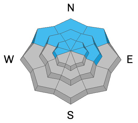
The DJL (Dry January Layer) is now buried 1 to 3 feet beneath the surface and has been responsible for four avalanche fatalities, several accidents, and more than 60 reported avalanches.

Over the past few days, signs of instability have become less obvious during backcountry travel and in snowpits, suggesting the snowpack is gradually gaining strength, especially in areas with deeper or fully saturated snow. This can create a false sense of security and draw people into avalanche terrain. We are still only a few days past the last significant, unique loading event. While the likelihood of triggering an avalanche is slowly decreasing, the consequences remain just as high. In my opinion, a lot of uncertainty still surrounds this snowpack structure, how the recent rain and heavy loading event have impacted it, and its spatial variability.

Recent avalanches, both large natural and human-triggered, highlight the high-consequence nature of this layer. Thinner snowpack areas remain particularly suspect, and avalanches can still be triggered remotely or from below. Continue to evaluate snow and terrain carefully, stay aware, and travel conservatively in the backcountry.

A large, natural avalanche on a northeast-facing slope at ~10,100 feet failing on PWL on Wednesday. (Photo: Solitude Snow Safety)

Avalanche Problem #2
Wind Drifted Snow
Type
Location
Likelihood
Size
Description

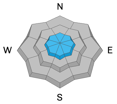
Sustained strong westerly winds continue to create thick, stiff slabs and large cornices along upper-elevation ridges. These slabs may be difficult to trigger but could break above you and carry into lower-angle slopes.

Watch for signs of wind-drifted snow, such as round, pillow-shaped drifts, and avoid those slopes.

Example of strong winds drifting along the Park City Ridgeline on Wednesday (B.Torrey)

Any avalanche initially triggered in the wind-drifted snow has the potential to step down, producing a much deeper and wider avalanche that fails on the persistent weak layer.

Avalanche Problem #3
Wet Snow
Type
Location
Likelihood
Size
Description

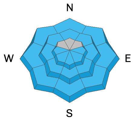
Previous rain on snow and warm temperatures have created a saturated, unsupportable snowpack at mid and low elevations.

As daytime temperatures rise and the surface crust softens, wet snow avalanches may be triggered.

Additional Information

I'll leave you with a final quote from Mark White's recently observation from the Monitors: "You’re not going to remotely trigger a slide at this point in time due to the thickness of the slab, but if you’re riding the face and hit a thin spot in the slab, you better have your life insurance paid off because it’s most likely going to be an unsurvivable avalanche."

General Announcements

This information does not apply to developed ski areas or highways where avalanche control is normally done. This forecast is from the U.S.D.A. Forest Service, which is solely responsible for its content. This forecast describes general avalanche conditions and local variations always occur.