25th Annual Black Diamond Fall Fundraising Party
Thursday, September 13; 6:00-10:00 PM; Black Diamond Parking Lot
25th Annual Black Diamond Fall Fundraising Party
Thursday, September 13; 6:00-10:00 PM; Black Diamond Parking Lot
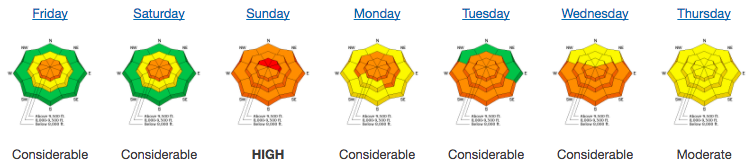
| Advisory: Salt Lake Area Mountains | Issued by Greg Gagne for Friday - March 9, 2018 - 5:09am |
|---|


|
bottom line A MODERATE hazard for triggering a persistent slab avalanche on slopes facing west to north through southeast at the mid and upper elevations. These slides may be triggered remotely, and may break out several hundred feet wide. Warming temperatures today will also lead to a period of wet loose activity on solar aspects, as well as all around the compass at lower elevations. SAFER riding conditions can be found on low angle northerly terrain with no overhead hazard. ROOF-ALANCHES are likely and have resulted in fatalities in years past.
|
 |
special announcement We have discount lift tickets for Alta, Snowbird, Solitude, Snowbasin,and Powdermountain. Details and order information here. All proceeds from these go towards paying for avalanche forecasting and education!
|
 |
current conditions Skies are partly cloudy and temperatures range throughout the 20's F. Winds are westerly and generally light, gusting in the teens at mid elevations, and 20's mph at the upper elevations. The recent warmth has taken a toll on our snowpack, with widespread sun and temperature crusts. Soft, dry, recrystallized snow can still be found on aspects facing due north above about 9000'. This past week included strong winds as well as a significant late-weekend storm, events that led to a week of avalanching with skiers and snow-machiners getting caught. Fortunately, no significant injuries. You can get caught up on these events by reading our Week in Review from Friday March 2 through Thursday March 8.
|
 |
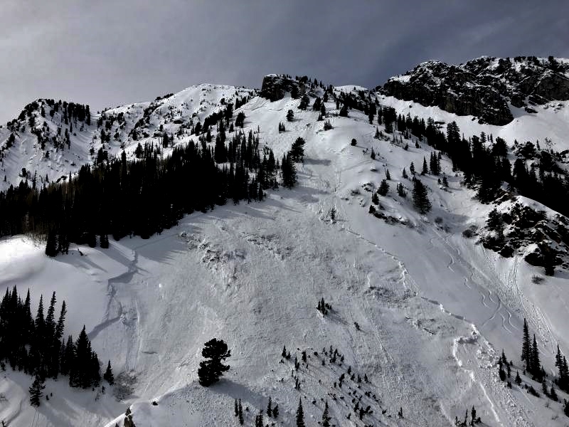
recent activity Yesterday's significant persistent slab activity: - Natural avalanche on southeast-facing Dresden Face in Hogum Fork failing in old snow. - A large skier-triggered slide on an east aspect at 9700' on Kessler Peak in Big Cottonwood Canyon. The rider was carried 300' and fortunately emerged with no serious injuries.
Mark Staples and Trent Meisenheimer went to the scene late yesterday afternoon and have an excellent accident write-up as well as video summary (pay particular attention to Mark's sage advice towards the end of the video): |
| type | aspect/elevation | characteristics |
|---|

|
|
LIKELIHOOD
 LIKELY
UNLIKELY
SIZE
 LARGE
SMALL
TREND
 INCREASING DANGER
SAME
DECREASING DANGER
|
|
description
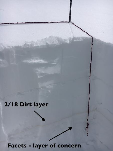
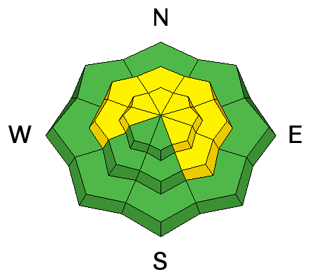
In addition to Thursday's activity, at least five other human-triggered avalanches were reported earlier this week on aspects facing north through southeast (see heat map for distribution by aspect and elevation.) The common ingredient? A layer of faceted snow that formed in early February and has since been buried by storm snow and wind-loading. This layer can be easily found by pulling out your shovel and looking for a prominent Feb 18 dust layer that is now buried 2-3' down from the surface. This faceted layer can be found 4-8" below this dust layer. The photo below is from Evelyn's field day in Red Pine Gulch, and her observation further describes how to identify this layer.
There is widespread spatial variability of the strength of this layer. Yesterday my partner and I were finding a strong, stable snowpack throughout one area in Millcreek Canyon, and then a very weak structure at the same aspect and elevation on an adjacent slope. And to further complicate things, weak faceted snow and depth hoar can also be found down near the ground, especially in thinner snowpack areas as well as slopes that have already slid. In some instances this week, slides have originated in the layer of facets below the dust layer, and then have stepped down to depth hoar near the ground. If you choose to ride in this steep terrain, you have to do your work and break out your shovel and dig down to evaluate the strength of these faceted layers, all the while keeping in mind that this weakness may be different elsewhere on the slope. (For example, notice the tracks on the slope adjacent to yesterday's Kessler slide.) Be sure to consider the consequences of getting caught in one of these slides. Don't roll the dice as the house usually wins. How can this persistent slab hazard be handled? Terrain is your friend: enjoy the powder on low angle slopes with no overhead hazard. |
| type | aspect/elevation | characteristics |
|---|

|
|
LIKELIHOOD
 LIKELY
UNLIKELY
SIZE
 LARGE
SMALL
TREND
 INCREASING DANGER
SAME
DECREASING DANGER
|
|
description
With warm temperatures expected today, expect continued wet-loose snow activity as the sun warms the snow surface. Cloud cover may also lead to afternoon greenhousing where low and mid elevation northerly aspects become wet. Fortunately wet activity has been held somewhat in check this week with cooperating periods of wind, clouds, and cooler temperatures, helping the solar aspects gradually adjust to warming from the sun. If you see signs of rollerballs and sloppy snow above the boot-tops, it's time to move to a shadier aspect. KEY POINT: ROOF-A-LANCHES will be a significant concern. Watch for many houses to shed their winter coats with the sun and daytime heating. Fatalities have occurred due to this very real hazard. |
 |
weather Partly cloudy skies and warm temperatures rising into the 30’s and low 40’s. Winds will be westerly, and generally light, gusting into the teens at mid elevations and 20’s at upper elevations. We may get a few snowflakes overnight into Saturday morning. Afterwards, a somber period of ridging through at least mid-week, with a hint of optimism for better* weather late this coming week. (* stormier) |
| general announcements CLICK HERE FOR MORE GENERAL INFO AND FAQ The UAC has new support programs with Outdoor Research and Darn Tough. Support the UAC through your daily shopping. When you shop at Smith's, or online at Outdoor Research, REI, Backcountry.com, Darn Tough, Patagonia, NRS, Amazon, eBay a portion of your purchase will be donated to the FUAC. See our Donate Page for more details on how you can support the UAC when you shop. Benefit the Utah Avalanche Center when you buy or sell on eBay - set the Utah Avalanche Center as a favorite non-profit in your eBay account here and click on eBay gives when you buy or sell. You can choose to have your seller fees donated to the UAC, which doesn't cost you a penny This information does not apply to developed ski areas or highways where avalanche control is normally done. This advisory is from the U.S.D.A. Forest Service, which is solely responsible for its content. This advisory describes general avalanche conditions and local variations always occur. |


 We Need Your Help With Social Media