AVALANCHE WARNING!! Tap for info
UDOT PLANNED AVALANCHE CLOSURES!!

Forecast for the Skyline Area Mountains

Brett Kobernik
Issued by Brett Kobernik on
Saturday morning, February 1, 2025
A little new snow and a lot of wind will increase the avalanche danger slightly today.
We will creep into the upper end of the MODERATE danger rating category.
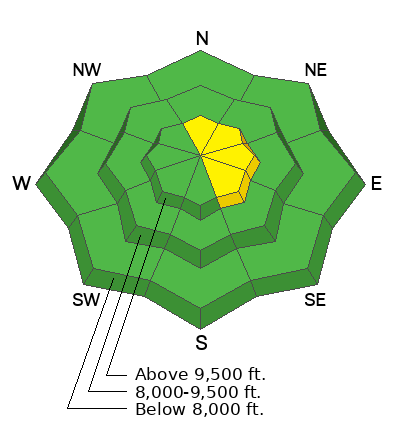
Freshly formed drifts and slabs in the mid and upper elevations are your main concern.
Most of these won't be all that large but there are scattered areas where they may break deeper causing a more serious avalanche.
Low
Moderate
Considerable
High
Extreme
Learn how to read the forecast here
Weather and Snow
Current Conditions: Riding conditions have been poor. Actually, some of the worst I can remember. Extended periods of wind along with no new snow has absolutely hammered the mid and upper elevation terrain. We did pick up 2 to 3 inches of new snow but that will hardly do anything to cover up the miles of bulletproof sastrugi. Temperatures were well into the 30s on Friday and were in the mid to upper 20s overnight. Wind from the southwest has increased into the moderate speed category with some stronger speeds along the more exposed terrain.
Mountain Weather: We might pick up a little more snow this morning but that's going to be about it out of this storm for us. The majority of the snowfall is going to stay to our north. Temperatures will get into the 30s again but not quite as warm as Friday. The wind looks like it is going to increase from the southwest and get quite strong this afternoon and especially tonight. Sunday is going to be warm and windy with cloudy skies. Very mild temperatures remain in place into mid week.
Ad
Avalanche Problem #1
Persistent Weak Layer
Type
Location
Likelihood
Size
Description
There are two things going on right now. First, there is plenty of loose sugary faceted snow present. It is both deeper in the snowpack and now on the surface as well. So, there are Persistent Weak Layers in place.
Second, the wind is going to drift the new snow and form fresh drifts, slabs and cornices. Anywhere these features form on top of loose sugary snow, they will most likely be sensitive.
My hunch is that most of these fresh drifts won't be all that large and probably won't pose a great threat. However, in scattered locations, they could break deeper which is a more serious situation.
Bottom Line: When we have weak layers of sugary faceted snow, it's best not to monkey around with any steep slopes that have fresh drifts of wind blown snow.
.
General Announcements
This forecast is from the U.S.D.A. Forest Service, which is solely responsible for its content. This forecast describes general avalanche conditions and local variations always occur.