Our Holiday Auction closes today! Check it out now to gear up for winter while supporting avalanche forecasting, awareness, and education across the state!
This Morning: Temperatures are in the upper 20's °F to low 30's °F. Winds are blowing from the west/northwest and have increased overnight, with gusts of 15-20 mph along exposed mid and upper elevation ridges, with stronger gusts near 40 mph at 11,000 feet. Skies are partly cloudy.
Today: Temperatures will be somewhat cooler today than they have been for over a week, rising into the mid and upper 30's °F, with 11,000 foot temperatures near 30° F. Winds will be from the west/northwest, with gusts in the 20's mph at 10,000 feet and near 30 mph at 11,000 feet. Skies will become partly to mostly cloudly.
Looking ahead, winds will increase overnight with snowfall beginning Wednesday morning. We are not expecting much snowfall from this first storm - around 4 inches of dense snow containing about 0.5 inches of water - with strong winds blowing from the west. Snowfall will taper off by late Wednesday, with additional dense snow and strong winds forecast through the weekend.
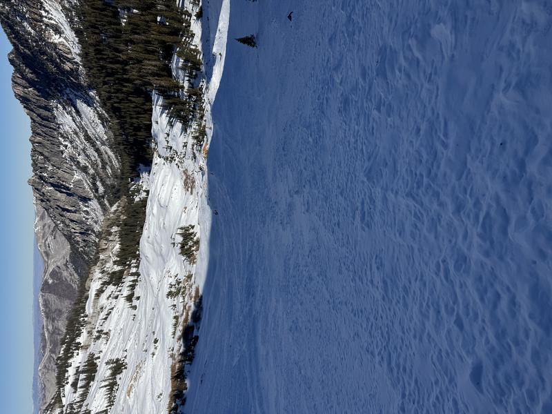
There is one to two feet of snow on northerly slopes, with south-facing slopes holding on to scraps of snow. Observers on Monday found a breakable crust on many surfaces and the weakening snowpack is becoming less supportable. The photo below is from pro observer Mark White in Cardiac Bowl on Tuesday, highlighting the meager coverage for mid December.
Forecasting how much snow/water and the rain/snow line will be challenging over the next several days.
No backcountry avalanches have been reported in over a week.