| Please join us at the 23rd annual Black Diamond Fall Fundraiser Party Thursday Sept 15. Tickets are on sale now here, at the Black Diamond store & at REI. Special bonus raffle for online ticket purchasers! |
| Please join us at the 23rd annual Black Diamond Fall Fundraiser Party Thursday Sept 15. Tickets are on sale now here, at the Black Diamond store & at REI. Special bonus raffle for online ticket purchasers! |
| Advisory: Ogden Area Mountains | Issued by Evelyn Lees for Wednesday - February 3, 2016 - 7:02am |
|---|


|
bottom line The avalanche danger is CONSIDERABLE on steep upper elevation slopes with new or old wind drifts. The drifts will become more widespread today as the winds increase. There is a MODERATE danger on upper and mid elevation slopes for triggering a slide on the buried surface hoar - the distribution of this layer remains uncertain. There remains a pockety, or isolated, CONSIDERABLE avalanche danger on steep, upper elevations slopes facing northwest through northeast where a slide breaking near the ground could be triggered, especially slopes that have already slid this year. Safer terrain choices with good powder conditions include lower angle, wind sheltered slopes.
|
 |
special announcement Yard Sale! Stop by our facebook page and check out some goods we have for sale, donated by our many supporters, including skis, clothes, bindings, boots, 2 nights at the Talking Mountain Yurts in the LaSal mountains. This helps to support avalanche forecasting and education. Tomorrow, Thursday 6:00pm - The Utah Adventure Journal Speaker Series presents professional skier Brody Leven, who will share the story of his incredible adventure to climb and ski the northernmost active volcano in a 36-hour push from his sailboat base camp. Next Wednesday February 10th - We have teamed up with Liberty Mountain to bring avalanche awareness to the ice climbing community. A special evening dedicated to discussing avalanche hazard as it relates to many popular climbing routes around Utah. Come learn which routes need to be avoided when avalanche danger is elevated and which routes provide a safer alternative when conditions are sketchy. For more info click here. There are still a few spaces in the Women’s Backcountry 101 avalanche classes at Brighton this weekend and Snowbasin in 2 weeks. For more info on those classes and other education offerings through out the state, check out our Education Page. |
 |
current conditions Temperatures remain cold this morning, in the single digits and teens in the Ogden area mountains. Skies are cloudy with some light snow, with the Ogden area mountains receiving up to 2" of snow overnight. Winds are from the northwest to southwest in the Ogden area mountains, and just starting to increase – now averaging to 20 mph across the highest ridges and peaks. Wind sheltered slopes have powder on all aspects; much preferred to the breakable wind slabs in exposed terrain. |
 |
recent activity We are saddened by the avalanche death of a backcountry skier who was killed Sunday, along the Park City ridge line. For the second time this winter, the community has lost a wonderful person to an avalanche, and our condolences go out to the family and friends of Steve Jones. A preliminary report is HERE, we will visit the site today. Avalanche reduction work in the Ogden area mountains released hard wind slabs in upper elevation terrain yesterday, on a variety of aspects, including southerly. Some of there were up to class 2 in size - large enough to bury a person. Below are the most recent backcountry Ogden area observations:
|
| type | aspect/elevation | characteristics |
|---|

|

|
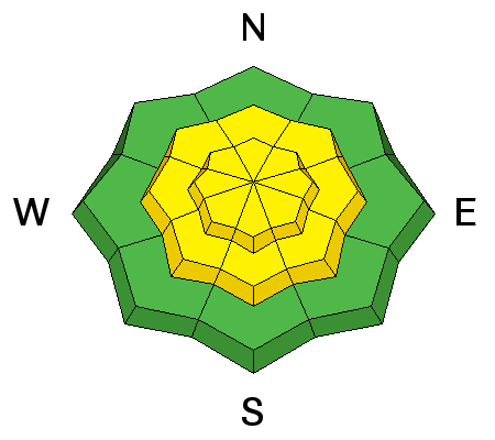
LIKELIHOOD
 LIKELY
UNLIKELY
SIZE
 LARGE
SMALL
TREND
 INCREASING DANGER
SAME
DECREASING DANGER
|
|
description
Just as the old hard wind slabs were starting to settle out, a new round of wind drifts will form today and tonight as the northwesterly winds increase. The old hard drifts will be stubborn, and could let you get out on the slab before failing. Today’s new drifts will be more reactive and cracky, and most widespread along the high ridge lines. Brian Smith vidoe from yesterday below.
|
| type | aspect/elevation | characteristics |
|---|

|
|
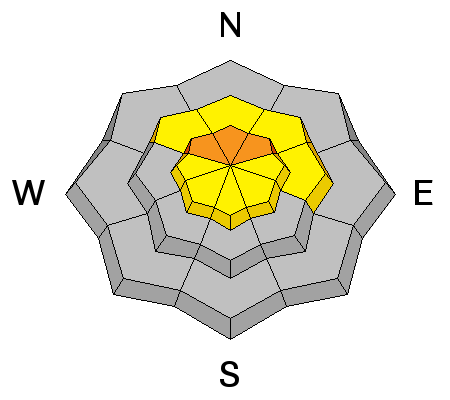
LIKELIHOOD
 LIKELY
UNLIKELY
SIZE
LARGE
SMALL
TREND
 INCREASING DANGER
SAME
DECREASING DANGER
|
|
description
The Ogden area mountains have a layer of surface hoar that got buried and preserved last Thursday, and loaded with another storm over the weekend and with wind events. I think in most places, there isn't enough of a load on the buried surface hoar for widespread or large avalanche, but the rain crust above could contribute to the slab properties and surprise us with wider slides. Collapsing or whoomphing are an indication you are on a slope with the faceted weak layer, and avalanches can be triggered from a distance with this weak layer. Dig down to these layers anytime you are getting onto steeper slopes -- this layering could be a problem for a long time. Kory Davis photo below of Ogden snow pack layering.
|
| type | aspect/elevation | characteristics |
|---|

|
|
LIKELIHOOD
LIKELY
UNLIKELY
SIZE
 LARGE
SMALL
TREND
INCREASING DANGER
SAME
DECREASING DANGER
|
|
description
The lack of recent deep slab avalanches in the Ogden area mountains could be due to a more stable snow pack or due to a lack of triggers. With all the activity in the more heavily used terrain to the north and south of the Ogden area mountains, I feel there must be a few places where a slide could break to the ground on upper elevation slopes that slid during the December avalanche cycle. Low probability, high consequence situation, and one very hard to verify with field work. |
 |
weather It’s going to be another cold day with out much warming – ridge line temperatures will stay in the single digits and 8000’ temperatures warm to near 15. The northwesterly winds will increase today, especially along the higher ridge lines, where averages to 35 mph, with gusts to 50 mph are possible. Mid elevation winds speeds will average 15 mph by this afternoon. Clouds and winds will continue to increase tonight through Thursday, as a small disturbance brings a few inches of snow on Thursday. |
general announcements
|