Observer Name
Park City Canyons Patrol, Mark Staples, Evelyn Lees
Observation Date
Tuesday, February 2, 2016
Avalanche Date
Sunday, January 31, 2016
Region
Salt Lake » Park City Ridgeline » Pointy Peak
Location Name or Route
near Shale Shot, in the Rip's Ridge/Pointy Peak area.
Elevation
9,100'
Aspect
Northwest
Slope Angle
40°
Trigger
Skier
Trigger: additional info
Unintentionally Triggered
Avalanche Type
Soft Slab
Avalanche Problem
Persistent Weak Layer
Weak Layer
Facets
Depth
3'
Width
45'
Vertical
300'
Caught
1
Carried
1
Buried - Fully
1
Killed
1
Accident and Rescue Summary
A 50 year old male skier, Stephen Jones, was reported missing Sunday night around 9 p.m. Summit County Search and Rescue conducted a search without much information on Monday and Tuesday. During the search, a member of the public notified Search and Rescue that they had seen Jones along the Park City/Mill Creek Ridgeline at 4 p.m. on Sunday above a slope called “Home Run”. Just north of “Home Run”, an avalanche was spotted on a treed slope along Rip’s Ridge just west of a slope called “Shale Shot”. A few other members of the public, who had seen Jones on Sunday, provided information that narrowed the search to this area.
On Tuesday, explosives were used to reduce avalanche hazard so rescuers could safely search the debris. Slopes in an east facing bowl with runs called Pointy Peak and Sound of Music and slopes adjacent to the avalanche were tested with explosives. Small new snow avalanches released in the east facing bowl; otherwise, explosive work did not trigger any other slides.
The area had been searched with a helicopter mounted RECCO detector and a search antenna that detects a transmitting avalanche beacon. No signals were detected, but tall trees prevented the helicopters from getting close to the debris. After explosive work was completed, ground teams searched the original avalanche debris with avalanche beacons. A searcher using a Pieps DSP detected a faint signal from Jones’ beacon (another Pieps DSP reported to be 10-15 years old). The initial distance reading was 26 meters. They discovered Jones Tuesday afternoon at approximately 1:50 p.m. He was buried about 2 feet deep with telemark skis still attached to his boots and poles attached with wrist straps.
The Utah Avalanche Center rated the avalanche danger in this terrain as Considerable on January 31, 2016. See danger rose and Bottom Line below from that day’s advisory.
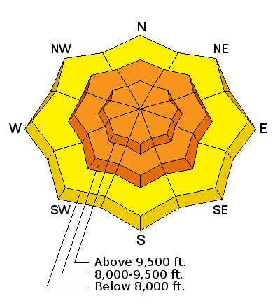
“The avalanche danger is CONSIDERABLE on upper and mid elevation slopes, where new snow soft slabs in wind drifted terrain and sluffs can be triggered on slopes approaching 35 degrees and steeper. If the winds increase where you are today, the danger will increase rapidly. There is a CONSIDERABLE danger on steep, upper elevation slopes were deep slides breaking near the ground can be triggered.”
The full advisory from that day can be found HERE
Terrain Summary
This north facing slope at an elevation of 9100 feet is not an obvious avalanche path because it is mostly tree covered. There is a small clearing where the avalanche released at 36 degrees in steepness which quickly steepens to 39 degrees. From a skier’s perspective this is a small seemingly benign slope unfortunately it is steep and open enough to produce an avalanche.

Weather Conditions and History
The weather has been complex this winter. November’s snow was followed by a long, dry spell with small, intermittent snow storms through early December. Periodic cold temperatures and clear skies faceted the shallow snowpack on shady slopes during this time. A series of storms between December 12th and 25th added several feet of snow to the snow pack and led to a major avalanche cycle.
Weather events became even more complex in January with a strong southeasterly wind event that scoured and loaded unusual aspects, producing another avalanche cycle. This was followed by small, almost daily storms between January 3rd and 8th. A dry spell between January 9th and 13th with warm sunny days and clear cold nights developed near surface facets on shady slopes and ice crusts on top of faceted snow on solar aspects.
Between January 14th and 20th, snow fell six out of seven days, culminating on January 20th with strong southwest to northwesterly winds, heavy snow and an active avalanche cycle.
A weekend storm January 30th and 31st resulted in about 12" of snow, and 1.25 inches of snow water equivalent along the Park City ridge line by Sunday morning, January 31st.
Snow Profile Comments
The snowpack on this slope was very thin compared to many other areas in the Wasatch. The avalanche broke about 4 feet deep at the wind loaded top of the slope. Lower down the snowpack depth was 2.6 feet and the avalanche broke about 2 feet deep on faceted snow crystals. Some depth hoar crystals were present as well. Many slopes that avalanched in December left thin, weak snowpacks. It is unclear if this slope had avalanched or not. This area typically receives less snow and has a thinner and weaker snowpack than heads of the Cottonwood Canyons.

Comments
This report contains information gathered by Utah Avalanche Center staff member Mark Staples who interviewed SAR members and from a site visit on Wednesday, February 3, 2016. Additional information came from the Summit County Sheriff’s Office.
Please direct any questions regarding this report to [email protected]
Mark Staples, Director
Forest Service Utah Avalanche Center
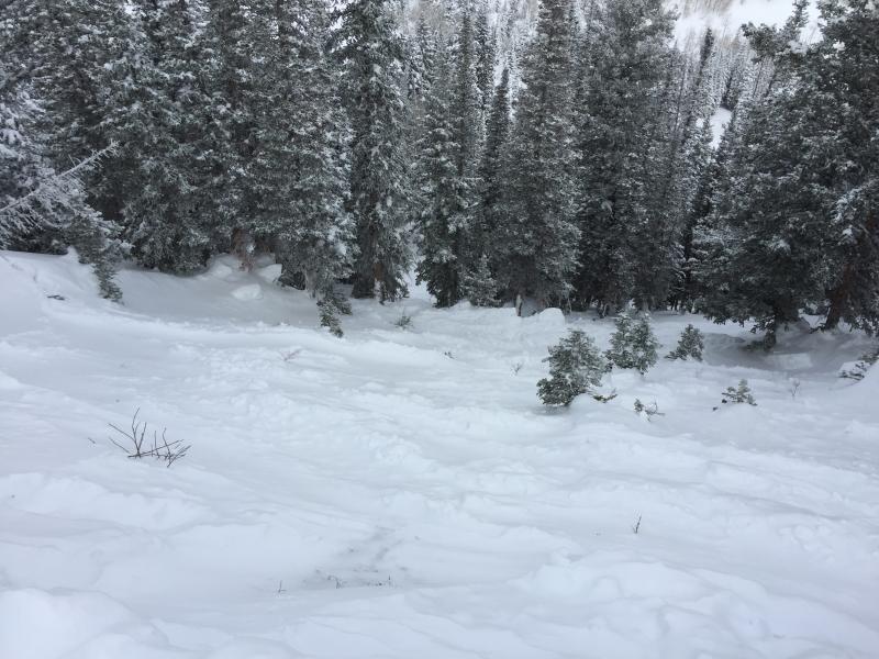
Photo looking down the avalanche path from the ridge top. The avalanche broke at the ridge where the slope was 36 degrees in steepness. About 20-30 feet downhill the slope steepens to 39 degrees. You can almost see the bottom of the slope through a small gap in the trees in the center of the photo.
Second photo shows the relative width of this avalanche. This path is small in comparison to bigger more obvious avalanche paths in the background of this photo.

Comments
Photo of the snowpack at the crown. The avalanche broke up to 4 feet deep at the center of the crown but was closer to 2 feet deep on either side.

Comments
The avalanche broke on a mix of facets and depth hoar 2-4 mm in size.

Comments
Jones' last know location was alone the ridge in the background of this photo. A skier can be seen climbing to this ridge.

Video
Coordinates


