

Forecast for the Skyline Area Mountains

Issued by Brett Kobernik for
Wednesday, January 12, 2022
Wednesday, January 12, 2022
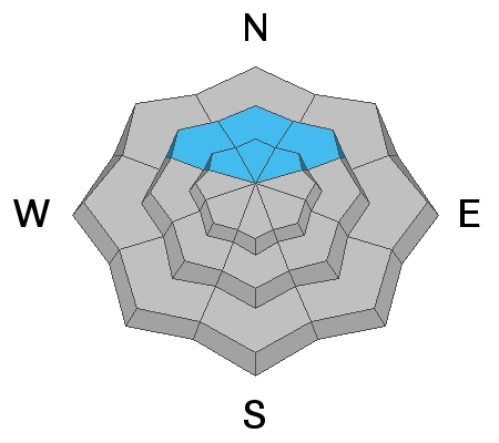
In most areas, the snowpack is looking pretty good and there is a LOW avalanche danger. A MODERATE avalanche danger still exists on mid and upper elevation northwest, north and northeast facing slopes steeper than about 35 degrees. The most likely place a person might trigger something is in an area with a shallow (thus weaker) snowpack.
Low
Moderate
Considerable
High
Extreme
Learn how to read the forecast here
 Special Announcements
FREE AVALANCHE AWARENESS CLASS!!
Thursday, January 13, 7pm
Big Pine Sports, Fairview, Utah
Dinner provided!!
Come learn more about avalanche safety. Topics include:
- How to read avalanche terrain
- Basic snowpack structure knowledge
- How to use the daily avalanche forecast
- Overview of manditory safety gear (beacon, shovel, and probe) as well as air bag information
- Q & A to help with any questions you may have
 Weather and Snow
Current Conditions
Tuesday was another spectacular day out in the mountains with mild temperatures, light wind and lots of great snow for riding still.
Mountain Weather
Today looks like a repeat of Tuesday with sunny mild weather. Wind speeds look like they'll increase a bit starting Thursday as a minor storm system brushes by to our north. For the longer term outlook, storms that were advertised for next week have dropped out of the weather model outputs. I'm thinking we're high and dry for another week at least.
Avalanche Problem #1
Persistent Weak Layer
Type
Location
Likelihood
Size
Description
I found snowpack conditions on both ends of the spectrum on Tuesday. Deep locations (areas with 5 to 6' of total snow) have very strong layers in the mid and upper pack. The old weak snow near the ground has gained strength. Snowpit tests did not yield any significant results. On the other end I also found shallow areas where the snowpack is "punchy" and contains loose sugary faceted snow. This was mostly on northwest facing slopes along the higher ridges where the wind has kept the total depths shallow. I felt comfortable getting onto some steeper north facing terrain but the slopes were quite short with no serious consequences if they would have avalanched.
Persistent Weak Layer Summary, 2021-2022:
There was a foot or more of snow that fell in October.
This snow melted away on many slopes but it stayed on northwest, north and northeast facing slopes above about 8500'.
The snow that stayed turned into a weak sugary layer during dry weather in November.
We saw a large amount of snow in December which landed on top of the weak snow from October.
The weak layer of sugary faceted snow collapsed and produced avalanches under the stress of the large storms.
The weak layer is still present. We are monitoring it and are hopeful it will become more stable with time.
Additional Information
General Announcements
This forecast is from the U.S.D.A. Forest Service, which is solely responsible for its content. This forecast describes general avalanche conditions and local variations always occur.