

Forecast for the Uintas Area Mountains

Issued by Craig Gordon on
Thursday morning, December 22, 2022
Thursday morning, December 22, 2022
Fresh snow and recent hurricane force winds weave the fabric of a slightly complex avalanche danger picture today-
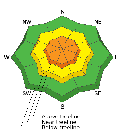
Around the compass you'll find CONSIDERABLE avalanche danger on all steep, upper elevation, wind drifted slopes. The danger is most pronounced in the wind zone at and above treeline, in terrain facing the north half of the compass, particularly on slopes with an easterly component to their aspect. Human triggered avalanches initiating in the storm snow and then breaking to weak, sugary, midpack snow are LIKELY.
Don't get surprised... winds penetrated mid elevation terrain as well where you'll find MODERATE avalanche danger and human triggered avalanches are POSSIBLE on recently wind drifted slopes.
Looking for the Clif-notes, fast-track version to LOW avalanche danger? Steer towards mid and low elevation wind sheltered terrain and slopes facing the south half of the compass with no overhead hazard (meaning, no steep slopes above or adjacent to where I'm traveling)
Low
Moderate
Considerable
High
Extreme
Learn how to read the forecast here
 Special Announcements
Please join Utah Avalanche Center forecaster Craig Gordon (that's me :) as I take a deep dive and reflect on recent close calls along with what’s going on with our current snowpack structure and what's in the store for the future.
Thursday December 22, 2022 6:00PM -Alpha Coffee -7260 Raquet Club Dr, Cottonwood Heights, UT 84121
As the end of the year approaches, please consider a donation to the UAC to support avalanche forecasting.
 Weather and Snow
Nowcast- Mother Nature rocked our mountains yesterday, but her powerful hands of change slowly turn down the volume on the wind machine this morning, though you'd hardly notice the muted touch as we ease from an eleven to ten on the dial. West and northwest winds still crank 40-70 mph near the high peaks and temperatures clock in right around zero, which equates to a dangerously crisp -30 degrees of windchill. Snow finally arrived overnight, though with the breezy conditions it's a shot in the dark for totals. I'll throw a little Ouija Board magic in here and overlap with a dart at the wall and say the high country stacked up 8" of medium density snow with .60" H2O. Riding and turning conditions took a hard hit, but I bet very wind sheltered low and mid elevation terrain will deliver soft, creamy snow.
Forecast- More blow than snow... the storm winds down with a couple inches of snow possible this morning and winds decrease into cow tipping range, blowing just 35-50 mph near the ridges. Temperatures claw their way into the low teens and crater to near zero overnight.
Futurecast- A weak storm system bumps through our zone Friday into Saturday bringing light snow to the area.
Lots of excellent trip reports and recent obs are found HERE.
 Recent Avalanches
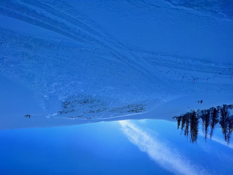
No recent avy activity since Tyler St. Jeor found this slide Sunday in Roundy Basin, just above the groomed trail on his way to Currant Creek.
From the North Slope to the south half of the range and points in between, recent human triggered avalanches display similar characteristics, revealing a failure in the midpack weakness which leads to avalanches gouging to the ground.
Recent avy activity and a slew of Uinta obs are HERE.

Avalanche Problem #1
Persistent Weak Layer
Type
Location
Likelihood
Size
Description

Two ways to view snow layering, but both suggest a general trend towards equilibrium.
The good news-
I don't think yesterday's storm changes this equation much. The midpack weak layer is adjusting to last weeks big storm, becoming happy in its own skin, and recent avalanche activity or lack thereof, reflects this trend.
The step out with cautious optimism news-
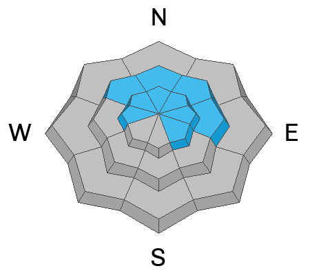
The most likely place to trigger an avalanche is where a dense, strong, solid layer (slab) rests on weaker snow (Persistent Weak Layer or PWL) formed during the mid November dry-spell. That combo is found on slopes facing the north half of the compass, especially those in the wind zone at and above treeline. So, by avoiding this setup, you essentially avoid avalanches!
The flake news-
I wanna know where I can ride, have a fun day, and NOT trigger an avalanche. And actually that's an easy one. Travel is straight-forward on a very supportable base and low angle terrain rides like a dream! With no shortage of great riding in big open meadows and on lower angle slopes, there's plenty of opportunity to avoid pulling on the avalanches dragons tail all together.
Avalanche Problem #2
Wind Drifted Snow
Type
Location
Likelihood
Size
Description
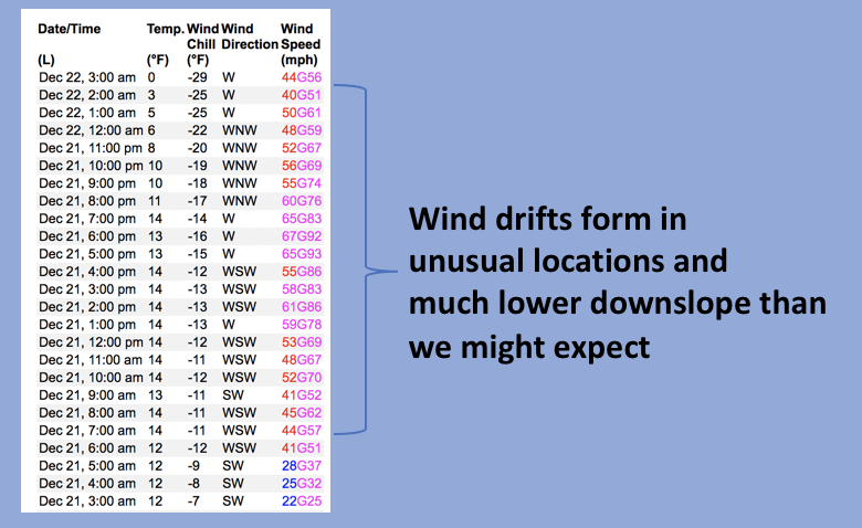
Above is a 24 hour data dump from Windy Peak (10,662')
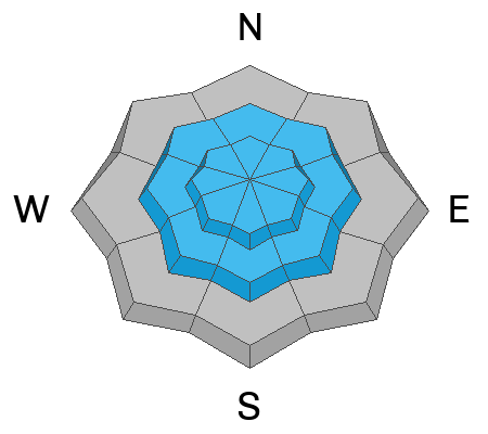
Winds blew from multiple directions and I bet you'll find shallow drifts all over the map, in some unusual locations, and lower downslope than we might expect to find them.
In either case, today you'll wanna key in on and avoid any fat looking rounded pillow of snow, especially if it sounds hollow like a drum.
Additional Information
State of the snowpack prezo Thursday Dec. 22nd... tonight-
When-
Thursday December 22, 2022
Show starts at 6:00
Thursday December 22, 2022
Show starts at 6:00
What-
Please join Utah Avalanche Center forecaster Craig Gordon (that's me :) as I take a deep dive and reflect on recent close calls along with what’s going on with our current snowpack structure and what's in the store for the future.
Please join Utah Avalanche Center forecaster Craig Gordon (that's me :) as I take a deep dive and reflect on recent close calls along with what’s going on with our current snowpack structure and what's in the store for the future.
Where-
Alpha Coffee
7260 Racquet Club Dr, Cottonwood Heights, UT 84121
Weather stations-
And... we were super busy this summer upgrading the western Uinta weather station network and this real-time winter info is found HERE (click weather stations, and then on the Western Uinta tab)
Observations-
Your observations are important, so please let me know what you're seeing... click HERE and contribute to this amazing community-based program
General Announcements
Issued at 03:42 on Thursday December 22nd, this forecast expires 24 hours after the date and time posted, but will be updated by 07:00 Friday December 23rd.
Before it gets too crazy, now is the time to book an avalanche awareness presentation for your group, club, or posse. You can reach Craig directly at 801-231-2170 or [email protected].
This forecast is from the U.S.D.A. Forest Service, which is solely responsible for its content. This forecast describes general avalanche conditions and local variations always occur.