

Forecast for the Uintas Area Mountains

Issued by Craig Gordon on
Friday morning, December 23, 2022
Friday morning, December 23, 2022
Steep, wind drifted slopes hang in a tenuous balance, just waiting for a trigger like us to roll along and knock the legs out from underneath-
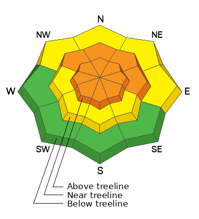
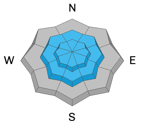
Around the compass you'll find CONSIDERABLE avalanche danger on all steep, mid and upper elevation, wind drifted slopes. The danger is most pronounced in the wind zone at and above treeline, in terrain facing the north half of the compass, particularly on slopes with an easterly component to their aspect. Human triggered avalanches initiating in the storm snow and then breaking to weak, sugary, midpack snow are LIKELY.
Don't get surprised... winds penetrated into lower elevation terrain as well where you'll find MODERATE avalanche danger and human triggered avalanches are POSSIBLE on recently wind drifted slopes.
Looking for the Clif-notes, fast-track version to LOW avalanche danger? Steer towards mid and low elevation wind sheltered terrain and slopes facing the south half of the compass with no overhead hazard (meaning, no steep slopes above or adjacent to where I'm traveling)
Low
Moderate
Considerable
High
Extreme
Learn how to read the forecast here
 Special Announcements
Huge thanks and ginormous hi-fives to Carl Churchill and the Alpha Coffee team along with everyone who took time out of their busy lives to attend last nights State of the Snowpack prezo. The vibe, energy, and stoke were all time. So, let's keep it tight and keep that spirit rolling throughout the winter :)
As the end of the year approaches, please consider a donation to the UAC to support avalanche forecasting.
 Weather and Snow
Nowcast- High clouds drift into the region ahead of a weak storm, slated to slide through area later this morning. In the meantime, we've clawed our way out of the deep-freeze and temperatures register in the single digits and low teens. Yesterday's hurricane force winds began decreasing in the morning and after a brief midday bump, continued mellowing out, currently blowing just 5-15 mph near the high peaks. Riding and turning conditions took a hard hit, but very wind sheltered low and mid elevation terrain will deliver soft, creamy snow.
Forecast- We might squeeze and inch or two of snow out of today's little storm, but in general it's a non-event. High temperatures climb into the 20's with overnight lows dipping into the teens. Northwest winds remain reasonably well-behaved, blowing just 10-20 mph along the ridges.
Futurecast- Another weak storm system bumps through our zone Saturday bringing an additional round of light snow to the area. Dry and warm for Sunday and Monday with storminess returning midweek.
Lots of excellent trip reports and recent obs are found HERE.
 Recent Avalanches
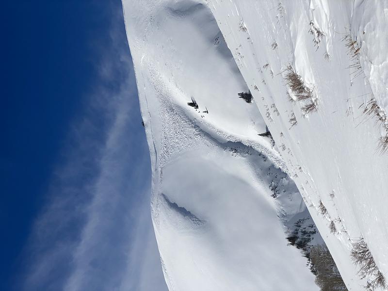
Initiating in the new snow and breaking to weaker, midpack PWL, this naturally triggered avalanche in Upper Weber Canyon, likely occurred Wednesday night as a result of the raging winds.
From the North Slope to the south half of the range and points in between, recent human triggered avalanches display similar characteristics, revealing a failure in the midpack weakness which leads to avalanches gouging to the ground.
Recent avy activity and a slew of Uinta obs are HERE.

Avalanche Problem #1
Persistent Weak Layer
Type
Location
Likelihood
Size
Description
The setup hasn't magically healed overnight and steep, wind drifted slopes are at a tenuous balance.
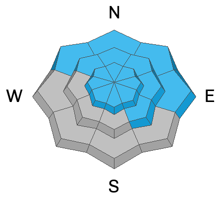
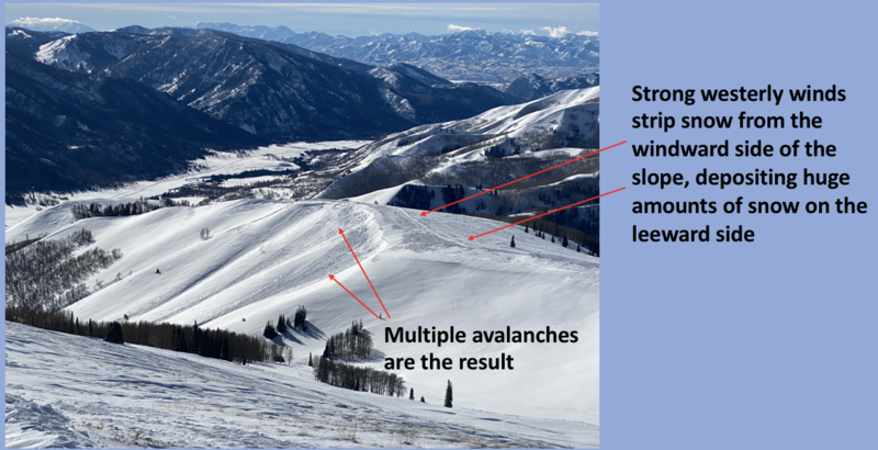
Winds are always the great equalizer on the eastern front and Wednesday nights hurricane force wind changed the landscape and tipped the scales. Now the tricky part... while some slopes avalanched naturally, others wait for a trigger like us to roll along and knock the legs out from underneath. And the most likely place to trigger an avalanche is where a dense, strong, solid layer (slab) rests on weaker snow (Persistent Weak Layer or PWL) formed during the mid November dry-spell. That combo is found on slopes facing the north half of the compass, especially those in the wind zone at and above treeline, and particularly on slopes with an easterly component to their aspect. So, by avoiding this setup, you essentially avoid avalanches!
My strategy is finding terrain I can ride, have a fun day, and NOT trigger an avalanche. And actually that's an easy one. Travel is straight-forward on a very supportable base and low angle terrain rides like a dream! With no shortage of great riding in big open meadows and on lower angle slopes, there's plenty of opportunity to avoid pulling on the avalanches dragons tail all together.
Avalanche Problem #2
Wind Drifted Snow
Type
Location
Likelihood
Size
Description
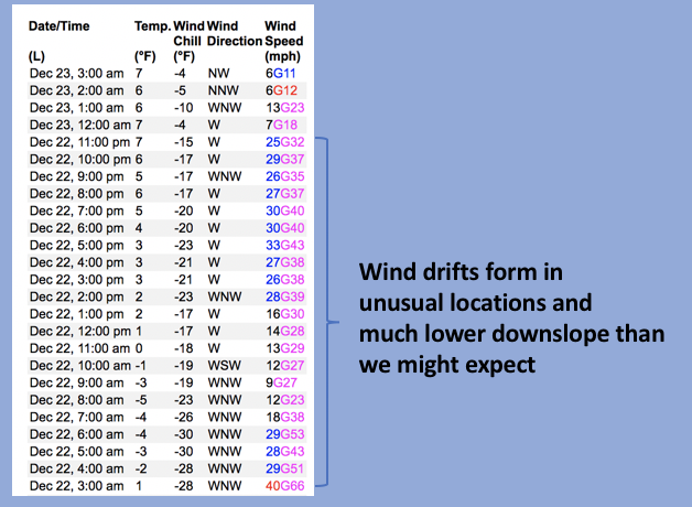
Above is a 24 hour data dump from Lofty Lake Peak (11,186')
Wednesday winds blew from multiple directions and I bet you'll still find rogue drifts all over the map, in some unusual locations, and lower downslope than we might expect to find them.
In either case, today you'll wanna key in on and avoid any fat looking rounded pillow of snow, especially if it sounds hollow like a drum.
Additional Information
Weather stations-
And... we were super busy this summer upgrading the western Uinta weather station network and this real-time winter info is found HERE (click weather stations, and then on the Western Uinta tab)
Observations-
Your observations are important, so please let me know what you're seeing... click HERE and contribute to this amazing community-based program
General Announcements
Issued at 04:12 on Friday December 23rd, this forecast expires 24 hours after the date and time posted, but will be updated by 07:00 Saturday December 24th.
Before it gets too crazy, now is the time to book an avalanche awareness presentation for your group, club, or posse. You can reach Craig directly at 801-231-2170 or [email protected].
This forecast is from the U.S.D.A. Forest Service, which is solely responsible for its content. This forecast describes general avalanche conditions and local variations always occur.