Forecast for the Skyline Area Mountains

Brett Kobernik
Issued by Brett Kobernik for
Thursday, January 13, 2022
No big change in conditions over the last few days.
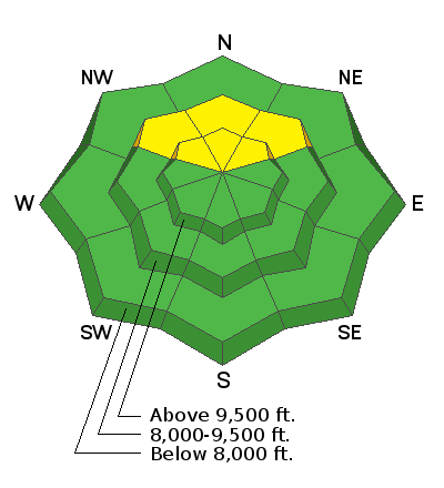
In most areas, the snowpack is looking pretty good and there is a LOW avalanche danger. A MODERATE avalanche danger still exists on mid and upper elevation northwest, north and northeast facing slopes steeper than about 35 degrees. The most likely place a person might trigger something is in an area with a shallow (thus weaker) snowpack.
Low
Moderate
Considerable
High
Extreme
Learn how to read the forecast here
Special Announcements
FREE AVALANCHE AWARENESS CLASS!!
Thursday, January 13, 7pm
Big Pine Sports, Fairview, Utah
Dinner provided!!

Come learn more about avalanche safety. Topics include:
  • How to read avalanche terrain
  • Basic snowpack structure knowledge
  • How to use the daily avalanche forecast
  • Overview of manditory safety gear (beacon, shovel, and probe) as well as air bag information
  • Q & A to help with any questions you may have
Weather and Snow
Current Conditions
We have a temperature inversion in place right now with warmer temperatures on the mountain peaks and colder temperatures at lower elevations. Overnight temperatures along the ridgetops were in the upper 30s while lower elevations ranged from the mid teens to mid 20s. The wind has been calm to light in speed. Riding conditions remain quite good.
Mountain Weather
A squiggle in the isobars is going to make a minor change in our weather. Colder air moves in through the weekend although it won't be all that cold. Highs on Friday will be in the low 20s and gradually rebounding through the weekend. We'll see the wind increase today and into Friday with moderate to strong speeds from a northerly direction. It'll calm down again for the weekend. The long range outlook is bleak with no storms advertised through the end of the month.
Ad
Avalanche Problem #1
Persistent Weak Layer
Type
Location
Likelihood
Size
Description
I am still closely monitoring the faceted snow near the ground. I've found that it has gained strength in many areas. Snowpit tests results are getting better. The mid and upper portions of the snowpack are very strong. After some more analysis over the next few days it is likely that we will drop the "Persistent Weak Layer" avalanche problem. Hopefully, the old snow at the base of the snowpack will no longer be a concern.

Persistent Weak Layer Summary, 2021-2022:
There was a foot or more of snow that fell in October.
This snow melted away on many slopes but it stayed on northwest, north and northeast facing slopes above about 8500'.
The snow that stayed turned into a weak sugary layer during dry weather in November.
We saw a large amount of snow in December which landed on top of the weak snow from October.
The weak layer of sugary faceted snow collapsed and produced avalanches under the stress of the large storms.
The weak layer is still present but has gained some strength. We are monitoring it and are hopeful it will become more stable with time.
General Announcements
This forecast is from the U.S.D.A. Forest Service, which is solely responsible for its content. This forecast describes general avalanche conditions and local variations always occur.