Forecast for the Skyline Area Mountains

Brett Kobernik
Issued by Brett Kobernik for
Tuesday, January 11, 2022
Avalanche conditions are relatively safe with the majority of the terrain having a LOW avalanche danger.
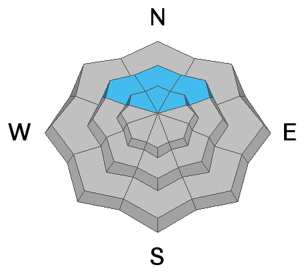
A MODERATE avalanche danger remains on mid and upper elevation northwest, north and northeast facing slopes. It is still possible to trigger a deep and dangerous avalanche that breaks into weak snow near the ground.
The most suspect terrain is slopes of 35 degrees in steepness or greater above 9000' on the north half of the compass. Chances for triggering something are low, consequences are high.
Low
Moderate
Considerable
High
Extreme
Learn how to read the forecast here
Special Announcements
FREE AVALANCHE AWARENESS CLASS!!
Thursday, January 13, 7pm
Big Pine Sports, Fairview, Utah
Dinner provided!!

Come learn more about avalanche safety. Topics include:
  • How to read avalanche terrain
  • Basic snowpack structure knowledge
  • How to use the daily avalanche forecast
  • Overview of manditory safety gear (beacon, shovel, and probe) as well as air bag information
  • Q & A to help with any questions you may have
Weather and Snow
Current Conditions
It was a very mild day on Monday with ridgetop temperatures into the upper 30s and light wind. Riding conditions remain good.
Mountain Weather
High pressure continues for the next couple of days with more mild weather. A very minor storm brushes by to our north late Thursday. This will bring an increase to the wind speeds. It looks like there will be a pattern change next week which will potentially bring some more storms.
Ad
Avalanche Problem #1
Persistent Weak Layer
Type
Location
Likelihood
Size
Description
Mild weather continues to help settle and stabilize the snowpack. We continue to go in a good direction as far as the weak snow near the ground gaining strength and not producing avalanches. Personally, I am still using caution on steep northerly facing terrain.

Persistent Weak Layer Summary, 2021-2022:
There was a foot or more of snow that fell in October.
This snow melted away on many slopes but it stayed on northwest, north and northeast facing slopes above about 8500'.
The snow that stayed turned into a weak sugary layer during dry weather in November.
We saw a large amount of snow in December which landed on top of the weak snow from October.
The weak layer of sugary faceted snow collapsed and produced avalanches under the stress of the large storms.
The weak layer is still present. We are monitoring it and are hopeful it will become more stable with time.
General Announcements
This forecast is from the U.S.D.A. Forest Service, which is solely responsible for its content. This forecast describes general avalanche conditions and local variations always occur.