Forecast for the Uintas Area Mountains

Craig Gordon
Issued by Craig Gordon for
Tuesday, January 30, 2024
What happened? I closed my eyes for just a minute, took a nap, but must've slept through February-
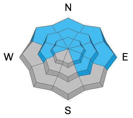
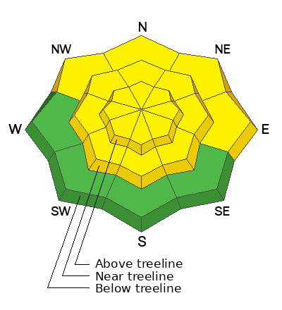
Look for MODERATE avalanche danger as strong sunshine and continued warm temps may irritate the mid December drought layer, now buried deep in the snowpack. Becoming more the exception then the rule, human triggered avalanches are still POSSIBLE, particularly on steep, rocky slopes facing the north half of the compass
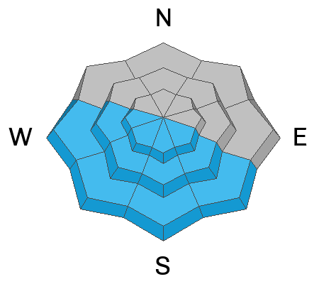
In addition, MODERATE avalanche danger is found on steep sunny slopes, where damp, loose avalanches come to life, especially during the heat of the day.

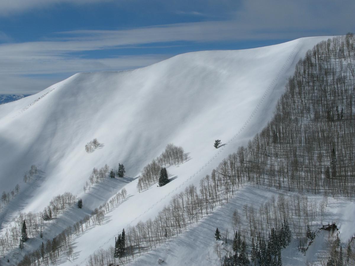
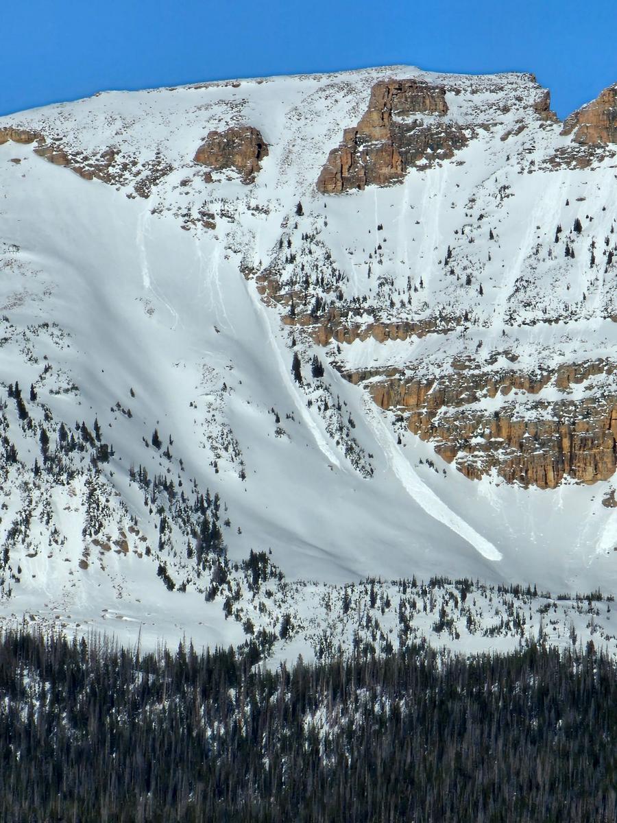
Note to self... this isn't your generic, run-of-the-mill MODERATE avy danger. In fact, this juncture of our snowpack lifespan takes some thinking with intent, particularly if I'm stepping into bigger terrain. Even though the odds of triggering a slide have decreased, the consequences remain the same... catastrophic if I make the wrong call. Deciding to "step out" takes some thought. I aim for places with a deeper snowpack and a clean runout zone, free of trees and rocks that will deliver major trauma. It may be counterintuitive, but slopes with thinner snow are the most likely places to trigger a slide that can quickly get out of hand as they fracture into deeper portions of the snowpack.
Low
Moderate
Considerable
High
Extreme
Learn how to read the forecast here
Special Announcements
"Miraculously, I came out on top of the snow that day over 30 years ago. I knew I was lucky to be alive, and I never wanted to experience that again...And when the avalanche problem type is a persistent weak layer, I’ll never say the danger is “only” moderate."
Read an excellent blog by Moab Forecaster, Eric Trenbeath about a moderate danger with a persistent weak layer.
Weather and Snow
Nowcast- Severe clear skies with hardly a high cloud in sight at o'dark allow overnight low temperatures to dip a few degrees cooler than yesterday at this time. Deep in the graveyard shift and looking forward to sunrise, a valley bottom inversion is in place as the mercury hovers in the mid 20's and registers near freezing along the ridges. Winds barely spin mountain top anemometers, blowing from the south at less than 10 mph. .
Forecast- Glorious weather is on tap today and Wednesday. Look for sunny skies, light winds, and temperatures climbing into the mid 30's. Overnight lows dip into the low to mid 20's.
Futurecast- A Pacific Storm system slides into the region by Thursday afternoon, bringing increased clouds, moisture, and strong southerly winds. Models have most of the initial energy focused on the south half of the state, but shifting north late in the weekend. The jury is still out and I'll keep you updated as deets become more aligned.
Snow conditions - Warm temps and strong sunshine have had their way with many aspects, especially down low where the sunny slopes and hard and crusty. But gain some elevation, swing over to the north half of the compass and you'll be rewarded with soft, creamy snow on a go-anywhere base.
Recent Avalanches
Not the Uintas, but remarkable avy footage from the Wasatch this weekend none-the-less.

Read more Uinta observations and avalanches HERE.
Ad
Avalanche Problem #1
Persistent Weak Layer
Type
Location
Likelihood
Size
Description
I'm beginning to slowly step into bigger terrain, but I'm nibbling at the edges... not center-punching or gobbling at the gut.
You'd really have to go out of your way to trigger a slide that breaks to older layers of snow today, but sunny skies, coupled with shallow pow on a go-anywhere base, tend to steer us into bigger terrain, especially slopes in the alpine. And while so much of the range avalanched during the mid January storm cycle, a few slopes remain intact, just waiting for us to roll along and tickle the right spot, and collapse the pack, often around a rock or bush barely hidden under the snow.
The good news is... the odds of triggering a slide on a persistent weak layer have decreased.
The less than ideal news is... it's not like lightning striking out of nowhere and it's not completely zero.
If you choose to enter avalanche terrain and ride steep slopes, stack the odds in your favor. Avoid areas of thinner snow near rocks (sometimes hard to do), make sure the runout zone is free of trauma-inducing trees and rocks, and make sure your partners watch you from a safe area.
Avalanche Problem #2
Wet Snow
Type
Location
Likelihood
Size
Description
Snow-pros and Inspired Summit Adventure backcountry guides extraordinaire, but more important... incredible humans, Shaun Raskin and Joey Manship stomped around the big alpine terrain in the Bald Mountain environs yesterday and spotted this damp slide peeling out of the hanging snowfields of Mount Agassiz. They've got an awesome trip report detailing their travels found HERE.
Keep an eye to the sky when you're traveling under the steep sunny slopes of Reids Peak, Bald Mountain, or Hayden Peak, especially as the day heats up. You could easily get clobbered by snow cascading off the high snow fields above.
Additional Information
Most SNOTEL sites have about average water content and snow now. Below is a graph from the Trial Lake SNOTEL showing the 30 year median (green line) and this year's precipitation (black line).
The Uinta weather station network was upgraded this summer and all that real-time info is found HERE. Simply click on "western Uinta" tab and then "weather stations" tab.

We are always looking for snow and avalanche observations or just general riding conditions. So... if you see something, say something. You can reach me directly at [email protected] or 801-231-2170.
Also, if you're looking for more avy education opportunities for yourself, your crew, or your club please don't hesitate to reach out to me and we'll find a presentation, class, or clinic for ya!
General Announcements

Issued at 0400 on Tuesday, January 30th this forecast will be updated by 0700 Wednesday, January 31st, 2024.
This forecast is from the U.S.D.A. Forest Service, which is solely responsible for its content. This forecast describes general avalanche conditions and local variations always occur.