Forecast for the Uintas Area Mountains

Mark Staples
Issued by Mark Staples for
Monday, January 29, 2024
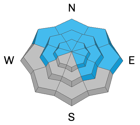
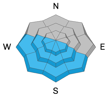
Today, the avalanche danger is MODERATE on all slopes. Many slopes have buried persistent weak layers that can still produce large slab avalanches. Slopes receiving direct sunshine should produce some wet loose avalanches.
This is not a normal moderate danger. I remain very hesitant to mess with avalanche terrain - even though the odds of triggering a slide have dropped, the consequences remain the same - deadly. If you do decide to "step out" a little bit and expand your terrain choices, aim for places with a deeper snowpack and a clean runout zone free of trees and rocks that will cause major trauma. It may be counterintuitive, but places with thinner snow are the most likely places to trigger a slide that can then fracture into deeper areas.
Low
Moderate
Considerable
High
Extreme
Learn how to read the forecast here
Special Announcements
"Miraculously, I came out on top of the snow that day over 30 years ago. I knew I was lucky to be alive, and I never wanted to experience that again...And when the avalanche problem type is a persistent weak layer, I’ll never say the danger is “only” moderate."
Read an excellent blog by Moab Forecaster, Eric Trenbeath about a moderate danger with a persistent weak layer.
Weather and Snow
Temperatures this morning are mostly in the upper 20s F with some trailheads a bit colder where cold air pooled overnight. High temperatures yesterday reached the 40s F in many places and will again today under clear sunny skies.
Winds remain light blowing from the north although they picked up at midnight at Currant Creek Peak gusting to 34 mph. Those winds should ease and today will hardly have any wind.
Warm and sunny weather continues until Thursday night. The jet stream should slam into Baja on Thursday, with energy and moisture being ejected upward into Utah with snowfall favoring southern mountains. The jet may move over Utah Sunday evening into the start of next week, bringing more snowfall. We'll watch how this all develops, but fingers crossed for more snow.
Snow conditions - The snow on slopes receiving direct sunshine as well as most low elevation slopes became quite wet yesterday. Shaded slopes still have creamy dry powder.
Recent Avalanches
There were some small wet loose avalanches I spotted yesterday coming off of rocky faces. Check out this avalanche that caught a skier in the Wasatch yesterday on Gobblers Knob. Make sure to watch the video. It is a good example of how you won't get any clues that a slope will avalanche until it does...spooky.

Read more Uinta observations and avalanches HERE.
Ad
Avalanche Problem #1
Persistent Weak Layer
Type
Location
Likelihood
Size
Description
There is a persistent weak layer (PWL) of faceted snow buried on most slopes except ones facing south and southwest. Most steep slopes have avalanched at least once if not multiple times, and the layers left behind are quite variable but still capable of producing a slab avalanche.
Yesterday while riding through a large chunk of the Uintas, my group experienced many collapses especially in rocky areas. Collapses are an obvious sign of instability we can't ignore. At the same time, we didn't see or hear about any recent slides. Craig got an overhead view of the Uintas yesterday and didn't spot any recent slides either. However, the skier triggered slide in the Wasatch Range, which generally has a stronger snowpack, is a good warning sign.
What does all this mean? The odds of triggering a slide on a PWL have gone down a lot, but they are not zero. If you choose to enter avalanche terrain and ride steep slopes, stack the odds in your favor. Avoid areas of thinner snow near rocks (sometimes hard to do), make sure the runout zone is free of trauma-inducing trees and rocks, and make sure your partners watch you from a safe area.
Avalanche Problem #2
Wet Snow
Type
Location
Likelihood
Size
Description
Expect to see some wet loose avalanches or wet sluffs especially around rocks that absorb a lot of heat. Below is an example of some we saw yesterday.
Additional Information
Most SNOTEL sites have about average water content and snow now. Below is a graph from the Trial Lake SNOTEL showing the 30 year median (green line) and this year's precipitation (black line).
The Uinta weather station network was upgraded this summer and all that real-time info is found HERE. Simply click on "western Uinta" tab and then "weather stations" tab.

We are always looking for snow and avalanche observations or just general riding conditions. So... if you see something, say something. You can reach me directly at [email protected] or 801-231-2170.
Also, if you're looking for more avy education opportunities for yourself, your crew, or your club please don't hesitate to reach out to me and we'll find a presentation, class, or clinic for ya!
General Announcements

Issued at 0700 on Monday, January 29th this forecast will be updated by 0700 Tuesday, January 30th, 2024.
This forecast is from the U.S.D.A. Forest Service, which is solely responsible for its content. This forecast describes general avalanche conditions and local variations always occur.