Forecast for the Uintas Area Mountains

Mark Staples
Issued by Mark Staples for
Sunday, January 28, 2024
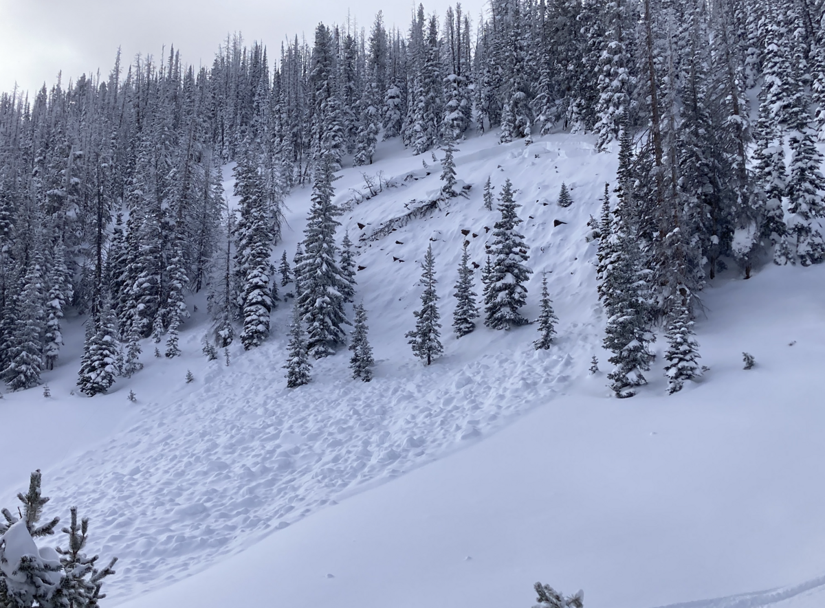
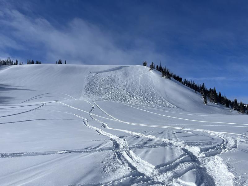
Please don't forget that just two weeks ago, the avalanche danger was extreme and avalanches were crashing down everywhere. The layers responsible for those conditions are still present in the snowpack.
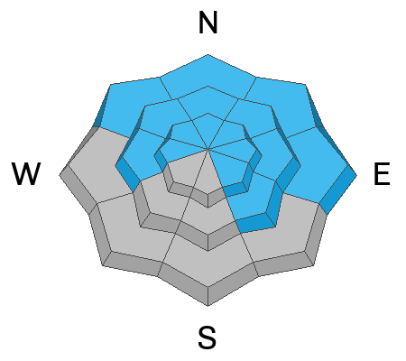
Today, because the likelihood of triggering a slab avalanche on buried persistent weak layers has lessened, the avalanche danger is MODERATE on all slopes facing north through east as well as slopes facing west and southeast near and above treeline. The danger is LOW on slopes facing south and southwest.
This is not a normal moderate danger. I remain very hesitant to mess with avalanche terrain - even though the odds of triggering a slide have dropped, the consequences remain the same - deadly. If you do decide to "step out" a little bit and expand your terrain choices, aim for places with a deeper snowpack and a clean runout zone free of trees and rocks that will cause major trauma. It may be counterintuitive, but places with thinner snow are the most likely places to trigger a slide that can then fracture into deeper areas.
Low
Moderate
Considerable
High
Extreme
Learn how to read the forecast here
Special Announcements
"Miraculously, I came out on top of the snow that day over 30 years ago. I knew I was lucky to be alive, and I never wanted to experience that again...And when the avalanche problem type is a persistent weak layer, I’ll never say the danger is “only” moderate."
Read an excellent blog by Moab Forecaster, Eric Trenbeath about a moderate danger with a persistent weak layer.
Weather and Snow
Temperatures were quite warm yesterday reaching the upper 30s F, and this morning they are mostly hovering around 32 deg F. At upper elevations they are in the mid to upper 20s F. Today temperatures will again rise into the upper 30s F and even into the low 40s in places.
Winds have generally been light, and this morning they are only blowing 7-17 mph from the north on the peaks with gusts in the 20s. Winds today will remain light and blow from the north. Scroll to the bottom of the page for graphical displays with more info about winds this month.
The weather this coming week will be warm and sunny until Thursday night. The jet stream should slam into Baja on Thursday, with energy and moisture being ejected upward into Utah. Southwest Utah will definitely receive snow in the mountains, and the Uintas should also do well. The jet may move over Utah Sunday evening into the start of next week, bringing more snowfall. We'll watch how this all develops, but fingers crossed for more snow.
Snow conditions - South facing slopes received a lot of heat the last two days, and the snow surface became damp. Craig reported an area of clouds in the Weber Canyon yesterday that allowed slopes at lower elevations facing all directions to take on some heat and become damp. Fortunately, storms in the middle of this month brought most SNOTEL sites back to average. Below is a graph from the Trial Lake SNOTEL showing the 30 year median (green line) and this year's precipitation (black line).
Recent Avalanches
There has been no shortage of avalanches. In fact we've only recorded a small portion of the ones that have happened. Below is a slide Dan G. spotted on Friday east of the Mirror Lake Highway. What catches my eye about this slide is that it is on a slope that wouldn't jump out to me as being dangerous. However, the rocks in the bed surface indicate that it's a steep, rocky pocket that appears to have a thinner and weaker snowpack.
The second photo below is a slide on Yamaha Hill near Humpy Peak that according to Ted "This slope avalanched earlier in the season and has likely stayed shallow with facets remaining on the bed surface." This slide highlights that many avalanche paths have released several times this winter and can continue to slide. They may have a thinner and weaker snowpack because they have shed their snow several times.

Read more Uinta observations and avalanches HERE.
Ad
Avalanche Problem #1
Persistent Weak Layer
Type
Location
Likelihood
Size
Description
Layers of weak faceted snow still lurk beneath our skis, boards, and tracks, but it's easy to forget it because the snowpack is so supportable in most places. These persistent weak layers are not done producing slab avalanches, but the likelihood has gone done (it doesn't turn off). The challenges is that many avalanche paths have released one or several times this winter and have a thinner snowpack.
Use your best detective skills to identify slopes where you're more likely to hit rocks. Those slopes are the most likely places to trigger an avalanche on these facets. Most likely areas are northerly, easterly, and upper SE facing slopes, but watch out for a few areas facing west near treeline.
Heads up - you will not get any feedback from the snowpack that it could produce an avalanche until it does.
Joey Manship and Wes Shirey said it best about these faceted layers: "I believe its starting to round [aka strengthen] but has a long way to go for any significant healing."
Additional Information
The pattern of winds during the last two weeks has been interesting. In the last 7 days (first wind rose) winds have been blowing from either the north or south with some slightly stronger winds from the SE. During heavy snowfall in the middle of January, hurricane-force winds blew from the west and southwest (second wind rose).
Winds on Windy Peak from Jan 21 to Jan 28.
Winds on Windy Peak from Jan 12 to Jan 16
The Uinta weather station network was upgraded this summer and all that real-time info is found HERE. Simply click on "western Uinta" tab and then "weather stations" tab.

We are always looking for snow and avalanche observations or just general riding conditions. So... if you see something, say something. You can reach me directly at [email protected] or 801-231-2170.
Also, if you're looking for more avy education opportunities for yourself, your crew, or your club please don't hesitate to reach out to me and we'll find a presentation, class, or clinic for ya!
General Announcements

Issued at 0700 on Sunday, January 28th this forecast will be updated by 0700 Monday, January 29th, 2024.
This forecast is from the U.S.D.A. Forest Service, which is solely responsible for its content. This forecast describes general avalanche conditions and local variations always occur.