Forecast for the Uintas Area Mountains

Craig Gordon
Issued by Craig Gordon for
Saturday, January 27, 2024
Note to self-
The snowpack will get its first taste of strong, late January sun along with warming temps. This combo may irritate the mid December weak layer, making it a little cranky and a bit more reactive to our additional weight.
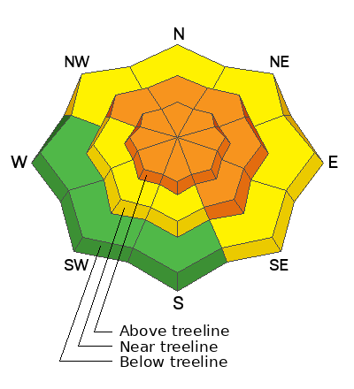
Not widespread and found mostly at and above treeline, pockets of CONSIDERABLE avalanche danger exist on all slopes, but particularly those facing the north half of the compass. Human triggered avalanches are LIKELY in wind drifted terrain, especially steep, rocky slopes in the wind zone with an easterly component to their aspect. Any slide you trigger today has the potential to break deeper and wider than you might expect... instantly ruining your day.

Look for MODERATE avalanche danger on mid elevation slopes near treeline facing west, southwest, and south, but also on lower elevation shady slopes as well. In either case, dense snow rests on weak, sugary snow and human triggered avalanche are POSSIBLE.
There are plenty of low angle options out there to avoid avy danger yet still get some great riding. It's simple, just steer your snow vehicle towards lower elevation terrain facing the south half of the compass where you'll find LOW avalanche danger and human triggered avalanches are UNLIKELY.
Low
Moderate
Considerable
High
Extreme
Learn how to read the forecast here
Weather and Snow
Nowcast- It's o'dark thirty and a waning Wolf Moon plays peek-a-boo behind thin clouds as high pressure builds in the region. It's a crisp morning, with temperatures registering in the low to mid teens. Winds blow from the west and northwest clocking in at 15-25 mph near the high peaks. Thursday night's shallow refresh delivered a nice spongy coat of white paint. While not enough body to cushion the old snow surface on low elevation sunnies, switch to the low angle shady's and you'll be rewarded with soft, creamy snow on a go anywhere base.
Forecast- High pressure settles in to play a multi-day gig, delivering a predictable setlist with sunny skies, northwest winds blowing 15-25 mph, and temperatures climbing into the mid 30's. Overnight low dip into the mid 20's.
Futurecast- A ridge (meaning high and dry... no moisture) builds in earnest through the weekend and into next week. Look for sunny skies, reasonable winds, and temperatures climbing into the upper 30's and low 40's by mid week. But don't let your heart be troubled... a glimmer of hope for storminess shines towards the end of the work week. I'll keep you updated as deets materialize.

Snow summary from NRCS SNOTEL sites:
Chalk Creek #1 (9,171') - 48" snow depth (11.0" total water)
Trial Lake (9,992') - 54" snow depth (11.1" total water)
Wolf Creek Peak (9,796') - 41" snow depth (9.1" total water)
Currant Creek (7,915') - 29" snow depth (6.9" total water)
Daniels-Strawberry (8,008') - 34" snow depth (9.2" total water)
Strawberry Divide (8,123') - 43" snow depth (11.7" total water)
Recent Avalanches
A meaty little pocket that could definitely roll you, Dan G spotted this rather fresh slab near Round Lake in his travels yesterday.
Also, Mark and Weston D discovered a very large avalanche in the Moffit Drainage Wednesday. Weston provides the narrative and a blow by blow description of this impressive slide HERE.
Trevor was out and about yesterday and spotted some older avy activity from about a week ago lower in Weber Canyon.
No shortage of noteworthy avy activity found HERE

Read more Uinta observations and avalanches HERE.
Ad
Avalanche Problem #1
Persistent Weak Layer
Type
Location
Likelihood
Size
Description
Mark rode in the alpine yesterday and found some curious discrepancies in snowpack depth and of course, snowpack strength.
The good news is... our snowpack is slowly healing and it's becoming slightly more comfortable in its own skin. The challenging reality is... the pack will give us a lot of false, green light feedback. The in yer face instabilities are gonna be more subtle. Gone are the days of loud, booming, tree shaking collapses and shooting cracks. In fact, the surface snow will ride like a dream, while the entire snowpack feels bomber and good to go under our skis, board, or sled. But we've gotta remember the mid January storm is a strong, cohesive slab resting on weak snow created during the mid December dryspell. And these are the exact conditions where we can ride plenty of slopes without incident, but find one slice of terrain where all the pieces align, knock the legs out from underneath, and the entire roof will caves in on us. Likely suspects include steep rocky slopes in the alpine with a shallow, weak snowpack.
Snwo-pros Joey Manship and Wes Shirey stomped around low in the Mirror Lake corridor and report a little encouraging news... "The 1F slab in gaining even more strength in this area. 1F is almost leaning towards pencil hardness and over 40cm thick. The PWL has gained some strength and is not reacting in pit tests but it is still dry loose 3-4 mm facets and over 50 cm thick. I believe its starting to round but has a long way to go for any significant healing."
Avalanche Problem #2
Wind Drifted Snow
Type
Location
Likelihood
Size
Description
Soft, fresh wind drifts-
Not widespread, but I bet there's a fresh wind drift or two that'll react to our additional weight. Found mostly on the leeward side of upper elevation ridges, don't be surprised with a drift or two lurking around terrain features like chutes and gullies.
Stiff, older wind drifts-
While more the exception than the rule, older, stiffer drifts formed during the big January storm are still found in mid and upper elevation, leeward terrain. Remember... even a small wind drift can break deeper and wider than you might expect as it crashes down on the slope below. A good rule of thumb is to simply avoid steep, wind drifted, leeward slopes, especially if they appear fat and rounded or sound hollow like a drum.
Additional Information
The Uinta weather station network was upgraded this summer and all that real-time info is found HERE. Simply click on "western Uinta" tab and then "weather stations" tab.

We are always looking for snow and avalanche observations or just general riding conditions. So... if you see something, say something. You can reach me directly at [email protected] or 801-231-2170.
Also, if you're looking for more avy education opportunities for yourself, your crew, or your club please don't hesitate to reach out to me and we'll find a presentation, class, or clinic for ya!
General Announcements

Issued at 0400 on Saturday, January 27th this forecast will be updated by 0700 Sunday, January 28th, 2024.
This forecast is from the U.S.D.A. Forest Service, which is solely responsible for its content. This forecast describes general avalanche conditions and local variations always occur.