UDOT PLANNED AVALANCHE CLOSURES!!

Forecast for the Salt Lake Area Mountains

Greg Gagne
Issued by Greg Gagne for
Friday, April 5, 2019
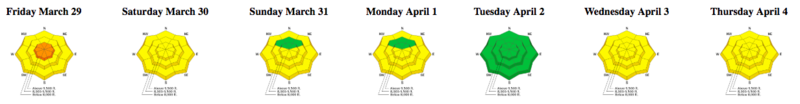
The avalanche hazard starts out generally LOW, possibly rising to MODERATE as the day warms when wet loose and wet slab avalanches are possible. Avalanche activity may be both natural and human-triggered. Although wet avalanches may be shallow, they may run long distances and produce deep debris piles.
Low
Moderate
Considerable
High
Extreme
Learn how to read the forecast here
Special Announcements
When the forecasting ends, the UAC’s work keeps going strong. Summer is a busy time for the UAC when we are working on our fall and winter planning; putting together the Fall Fundraiser and the Utah Snow and Avalanche Workshop (USAW); updating our awareness and education programs. In addition, this summer we will be finishing up the website redesign project. Your donation shows you’re invested in this community all year round! You can still be part of the UAC’s success in 2019.
Grizzly Gulch will be closed on Sunday April 7 and Monday April 8 as Alta conducts rescue training.
Weather and Snow
Currently: Skies are partly cloudy and mountain temperatures are generally a few degrees on either side of freezing, with the coldest temperatures at 11,000’ where they are in the mid 20’s F. South/southwest winds increased overnight, with some stations above 10,000’ averaging in the teens and gusting into the 20’s mph. 11,000’ stations are gusting into the 30’s and low 40’s mph.
Today: Skies will be partly cloudy and it will continue to be warm. Temperatures will rise into the 30’s and 40’s F. through at least the mid elevations. Even the upper elevations will rise above freezing. Winds will be out of the south/southwest, averaging in the teens with gusts in the 20’s at the mid elevations, with gusts in the 30’s at the upper elevations.
Tonight: A more promising setup beginning overnight with 3-6” of snowfall by later Saturday morning.
The Week in Review can be found by clicking here.
Recent Avalanches
The only avalanche activity reported from Thursday included natural and skier-triggered wet loose avalanches during the afternoon. Some of these ran long distances (up to 1000’) with debris piles deep enough to bury a person. However, some reports indicated clouds and just enough wind limited wet activity. Drew was in Cardiff Fork and you can read his observation here.
Ad
Avalanche Problem #1
Wet Snow
Type
Location
Likelihood
Size
Description
The primary avalanche hazard today is wet avalanche activity related to warming. The snowpack has now had over a day to adjust to warming, and clouds and winds may further limit wet activity today. But if the snow surface warms up where you are, natural and human-triggered avalanches are possible involving wet loose snow sluffs or larger wet slab avalanches. This hazard exists in steeper terrain, especially on aspects facing west, south, and east, as well as on all aspects at the mid and lower elevations. These slides will run on crusts underneath Wednesday's storm snow, or possibly gouge down more deeply into the snowpack, potentially entraining large amounts of dense, heavy, wet snow.
Fortunately the snowpack gives us plenty of clues when the avalanche problem involves wet snow. Evidence includes wet rollerballs (as shown below) or larger wet loose avalanches. As soon as the crusts soften and becomes soggy and unsupportable, it’s a sign of unstable wet snow, and time to move off of and out from underneath steeper slopes. Avoid terrain traps such as the gully bottoms.
Avalanche Problem #2
Normal Caution
Type
Location
Likelihood
Size
Description
Risk is inherent when traveling in the mountains. In addition to wet snow concerns, there are a few others you should watch for, especially if you opt to head for shadier, upper elevation aspects:
Wind Blown snow - Although there isn't much dry snow available for transport, winds did increase overnight and you may find a pocket of fresh wind-drifted snow on upper elevation northerly slopes.
Cornices will be more sensitive today with heating. Minimize your travel time below overhanging cornices and stay well back from the edges of the cornices when traveling on ridge lines.
Glide cracks will remain active through the spring, certainly in the standard areas of Broads, Stairs, and Mill B South of BCC, upper Porter Fork (Raymond Slabs), and other areas where the glide cracks are opening (such as the prominent glide crack on Cardiac Ridge). The resulting debris piles are unsurvivable. Avoidance is key - minimize or completely avoid travel below the large cracks.
General Announcements
This information does not apply to developed ski areas or highways where avalanche control is normally done. This forecast is from the U.S.D.A. Forest Service, which is solely responsible for its content. This forecast describes general avalanche conditions and local variations always occur.