Forecast for the Salt Lake Area Mountains

Drew Hardesty
Issued by Drew Hardesty on
Tuesday morning, March 3, 2026

A CONSIDERABLE avalanche danger exists in the upper elevation bands this morning. Here, you're likely to trigger 1-2' thick soft slabs, particularly in steep wind drifted terrain. Natural avalanches aren't out of the question. Any new snow avalanche on the north side of the compass may step down into older weak layers, resulting in a more catastrophic avalanche.

My advice would be to step back and choose low angle terrain while the storm snow stabilizes over the course of the day.

Low
Moderate
Considerable
High
Extreme
Learn how to read the forecast here
Special Announcements

The Caribou Basin final accident report was published last night. Now all four final accident reports (Caribou Basin, Butler Basin, Lake Mary Chutes, and Ant Knolls) have been published. You can find them all HERE>

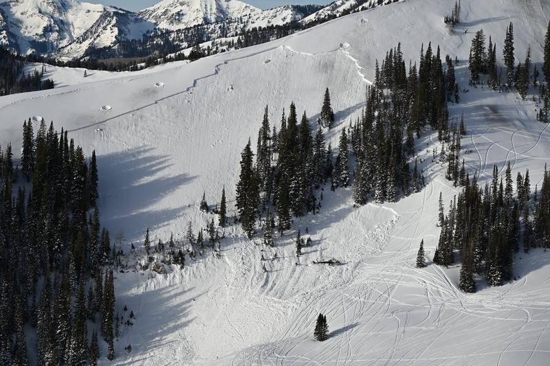
Drone footage of the Caribou avalanche after avalanche control work had been conducted to reduce the risk to the SAR teams.

Thank you to everyone involved for sharing information. As with all avalanche accidents, we hope to learn something to prevent future accidents. Our deepest heartfelt condolences go out to the families, friends, rescuers, and everyone affected by these tragic accidents.

Weather and Snow

We're back in the flow.

Moderate to high rates of snowfall fell overnight with the cold front, with temperatures dropping to a more reasonable low to mid-20s. Winds are from the west northwest, blowing 15-20mph with gusts to 35. Along the highest peaks and ridgelines, winds averaged 30-50mph overnight and are currently blowing 25-40mph with gusts to 45. Storm totals (as of 5AM) are below:

LCC: 12"/1.40" H20

BCC: 7"/0.65"

PC: 6"/0.65"

Ogden 10"/1.20"

Provo 2"/0.30"

It's still snowing...but things should start to wind down this morning. Skies will trend partly cloudy by the afternoon with temps in the low to upper 20s. I expect the winds to lose steam as they veer north and perhaps northeast over the course of the day. Wednesday will be gorgeous with another storm on tap Wednesday night through Friday. This storm will be colder and I can picture a clean 12-18" of powder, perhaps more, by late Friday.

Recent Avalanches

Yesterday a skier in the very unforgiving terrain of Holy Moly (north side of Toledo) triggered and was caught and carried in not one but two wind slabs. The two wind slabs were up to a foot deep and estimated to be 35' and 150' wide, respectively.

His report and footage is HERE; we're thankful for the report and that he's ok.

https://www.youtube.com/watch?v=ts5uAdGF1gc

Avalanche Problem #1
Wind Drifted Snow
Type
Location
Likelihood
Size
Description

You will be able to trigger lingering and fresh slabs of wind drifted snow on all aspects (though more pronounced on north>southeast) in the upper elevation bands today. They will be more pockety in the mid-elevations. These wind drifts (slabs) will be up to 2' thick and most sensitive this morning through the early afternoon hours. Shooting cracks are dead give-aways to localized instability and test slopes should also offer good indication of current problems with the wind.

Avalanche Problem #2
New Snow
Type
Location
Likelihood
Size
Description

New snow instabilities are most sensitive during and just after high snowfall intensity. Look for the new snow to move with provocation on all aspects this morning.

Avalanche Problem #3
Persistent Weak Layer
Type
Location
Likelihood
Size
Description

The weak January facets (Dry January Layer DJL) haven't gone away and are now receiving additional stress with the new snow and wind. With time, the likelihood of triggering one of these avalanches has diminished, but the uncertainty level has increased: when, where, and how might I trigger this monster today? Know that it may be possible for any new snow or wind slab avalanche to step down into these older weak layers, resulting in a more destructive avalanche.

I would approach any steep slope that harbors this layer of facets with extreme caution.

General Announcements

This information does not apply to developed ski areas or highways where avalanche control is normally done. This forecast is from the U.S.D.A. Forest Service, which is solely responsible for its content. This forecast describes general avalanche conditions and local variations always occur.