Forecast for the Salt Lake Area Mountains

Drew Hardesty
Issued by Drew Hardesty on
Wednesday morning, March 4, 2026

A MODERATE avalanche danger exists on many slopes today and - without care - you may be able to trigger soft slabs of wind drifted snow or long running wet loose sluffs; each big enough to catch, carry and bury you. In isolated areas on the north side of the compass, it may be possible to trigger a hard slab that fails 2-4' deep on old weak faceted snow.

Evaluate snow and terrain carefully today. Full stop.

Low
Moderate
Considerable
High
Extreme
Learn how to read the forecast here
Special Announcements

All four final avalanche accident reports (Caribou Basin, Butler Basin, Lake Mary Chutes, and Ant Knolls) have now been published. These are reports of four avalanche fatalities in five days spanning February 18th-February 22nd. You can find them all HERE>

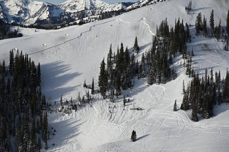
Drone footage of the Caribou avalanche after avalanche control work had been conducted to reduce the risk to the SAR teams.

Thank you to everyone involved for sharing information. As with all avalanche accidents, we hope to learn something to prevent future accidents. Our deepest condolences go out to the families, friends, rescuers, and everyone affected by these tragic accidents.

Weather and Snow

Skies are clear. But not for long: we have a classic Wasatch storm on tap for tonight through late Friday.

Temps are in the 20s; winds - hardly a whisper yesterday - have increased out of the south-southwest and are blowing 10-15mph with gusts to 20.

For today, we'll see increasing clouds, elevating winds, and temps again rising into the upper 30s up high, the 40s down low. A strong cold front arrives overnight, accompanied by heavy snowfall and plummeting temperatures. There is some chance of the lake effect kicking in and my overall storm totals are roughly 12-18"+ with an inch to an inch and a half of water by later Friday. Our partners at the SLC National Weather Service have issued a Winter Storm Watch.

Riding conditions on Monday night's 8-12" of dense snow were fast and surfy, but localized greenhousing and sun yesterday installed a breakable crust on all aspects up to 9500-10,000' and on many solar aspects, respectively. Many crusts should soften with today's sun and warmth.

The Outlook: Some clearing for the weekend, with an somewhat active pattern for next week. The longer range models aren't in much agreement, so we'll see...

Dusk patrol lighting on south Superior, Bo Torrey

Recent Avalanches

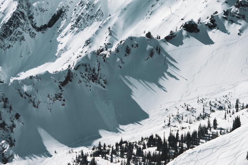
Wind Slabs: Ski areas reported fairly active conditions yesterday, with numerous ski cut and explosive-triggered wind slabs in the upper elevations. This jived with backcountry activity - skiers triggered avalanches in the Toledo Chutes and the Cardiff Chutes (good write-up HERE, Torrey pic below) , with a natural noted off the AF Twins. Most of these wind slabs had an easterly component (faced NE>SE). None (that we are aware) of these stepped down into the old faceted snow from January (the January Dry Layer).

THANKS to all the parties who called Alta Central (801-742-2033...or PC Canyons Dispatch - 435-615-1911 on the PC Ridge) - to report avalanches in the vicinity of the town and/or ski areas. THIS really helps save SAR personnel and resources from needlessly sticking their necks out while responding to empty debris piles.

Sun/Cloud cover > Wet slides: What's the old saying, Fool me once, shame on you; fool me twice, shame on me; fool me 17 times, I'm sure I'll get it right the next time. The clouds parted a touch earlier than I expected and that strong March sun and rapidly warming temperatures allowed for some natural and skier-initiated wet loose slides, involving one catch and carry on west facing Patsy Marley yesterday (Microwave).

Avalanche Problem #1
Wind Drifted Snow
Type
Location
Likelihood
Size
Description

You will be able to trigger lingering and developing soft slabs of wind drifted snow on all aspects (though more pronounced on north>southeast) in the upper elevation bands today. They will be more pockety in the mid-elevations. These wind drifts (slabs) will be up to 2' thick and some may be triggered at a distance in the afternoon.

Wind slab (unknown trigger) on the American Fork Twins yesterday

Avalanche Problem #2
Wet Snow
Type
Location
Likelihood
Size
Description

While I do expect riders to be able to trigger some wet loose sluffs on solar aspects today, my sense is that enough wind and increasing cloud cover will keep the world entire from becoming unglued. STILL - pay attention to how the snow feels under your feet or ride and take note of rollerballs and other wet activity and adjust your travel accordingly.

Avalanche Problem #3
Persistent Weak Layer
Type
Location
Likelihood
Size
Description

The weak January facets (Dry January Layer DJL) haven't gone away. With time, the likelihood of triggering one of these avalanches has diminished, but the uncertainty level has increased: when, where, and how might I trigger this monster today? Know that it may be possible for any new snow or wind slab avalanche to step down into these older weak layers, resulting in a more destructive avalanche. This possibility is perhaps more likely in and along thinner, rocky snowpack areas or along the PC ridge or Mill Creek.

Avalanche occurrence on the PWL chart below -

I would approach any steep slope that harbors this layer of facets with caution.

Additional Information

Forecaster's Corner: if you're out today, it'll be important to take a look at the snow surfaces. This will help to gauge how well the overnight storm snow may bond to these "old" snow surfaces. For example, if you're noting surface hoar or the surface is starting to square-off and facet, consider these "yellow flags" for conditions on Thurs/Friday. My own suspicion is that you may find some surface hoar and surface weaknesses this morning, but wind, sun, and temps may destroy most of it prior to tonight. But - science! - test your hypothesis.

General Announcements

This information does not apply to developed ski areas or highways where avalanche control is normally done. This forecast is from the U.S.D.A. Forest Service, which is solely responsible for its content. This forecast describes general avalanche conditions and local variations always occur.