Forecast for the Salt Lake Area Mountains

Drew Hardesty
Issued by Drew Hardesty on
Friday morning, February 6, 2026

We have the avalanche danger pegged at MODERATE today for wet loose sluffs on nearly all aspects and elevations (but high northerlies). You'll need to pay attention to how the snow is behaving under your feet or in steep terrain. NOTE that many polar aspects may dampen and produce shallow wet sluffs today.

Grey on low elevation solar aspects indicates that there is little to no snow in this terrain.

Low
Moderate
Considerable
High
Extreme
Learn how to read the forecast here
Special Announcements

Greatest Rain on Earth?!?: Forecaster Drew Hardesty penned a new essay about high-elevation rain and the warm-snow drought HERE.

Weak Snow: Today's Surface, Tomorrow's Avalanche Problem: Essay by UAC Director Paige Pagnucco HERE.

Weather and Snow

Skies are clear.

With the ridge axis shifting to the east, winds have backed to the south (blowing from the south), blowing 10-15mph with gusts to 20. Mountain temperatures are currently in the mid to upper 30s. A few stations in the mid-elevation thermal belt sit at an even 40°F.

For today, we'll have temperatures rising to the mid to upper 30s up high, the mid to upper 40s down low. It won't be quite the scorcher as it was yesterday, but we'll see increasing high and then mid-level clouds that might lead to greenhousing in select terrain. Mild weather follows for the weekend ahead of a cold front slated for Monday afternoon. I think it's a bit too early to say that the wicked witch is dead, but all signs point to a pattern change early next week. I mean, it might even snow.

The Week in Review is hot off the press. You can find it HERE.

Recent Avalanches

With direct sun and scalding temperatures, skiers and riders were able to trigger wet loose sluffs, particularly on south and east facing slopes yesterday. Some sluffs ran a few hundred feet and were large enough to bury a person, particularly in a terrain trap.

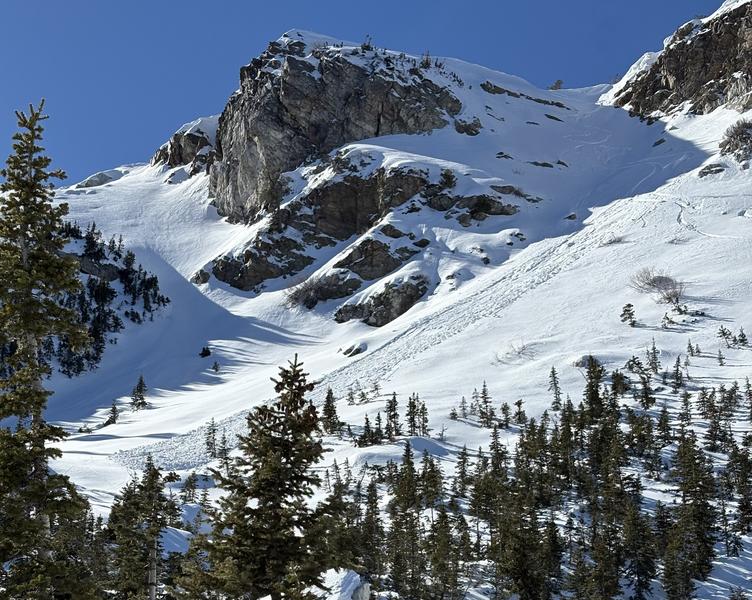
Skier triggered wet loose sluff, Bountiful Peak (East-southeast facing slope @ 9000'), pc: Logan Jamison

Despite the lack of interesting weather, we continue to receive thoughtful and interesting observations.

Avalanche Problem #1
Wet Snow
Type
Location
Likelihood
Size
Description

We already start out the day with overnight "lows" in the mid to upper 30s. Throw in some likely greenhousing with some mid and high level clouds, and now it will be possible to trigger damp or wet loose sluffs on all aspects and elevations, but for high northerlies.

Wet loose sluffs are slow and break at your feet (rather than above you), but they are dense and pack a punch and bury you like concrete. It'll be key that you are your own forecaster and observe how the snow is behaving under your feet and in steep terrain. IF you're finding the snow to be punchy and unsupportable..and/or seeing natural loose wet sluffs, it's time to call it a day.

NOTE: WHAT MAY BE DIFFERENT is that some cold, polar aspects may become damp and...like most of us...snow does not like rapid change. Keep a heads-up today.

General Announcements

This information does not apply to developed ski areas or highways where avalanche control is normally done. This forecast is from the U.S.D.A. Forest Service, which is solely responsible for its content. This forecast describes general avalanche conditions and local variations always occur.