Forecast for the Salt Lake Area Mountains

Bo Torrey
Issued by Bo Torrey on
Saturday morning, February 14, 2026

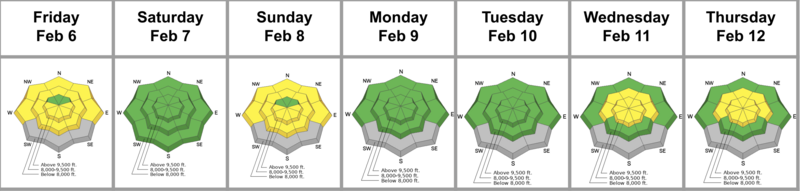
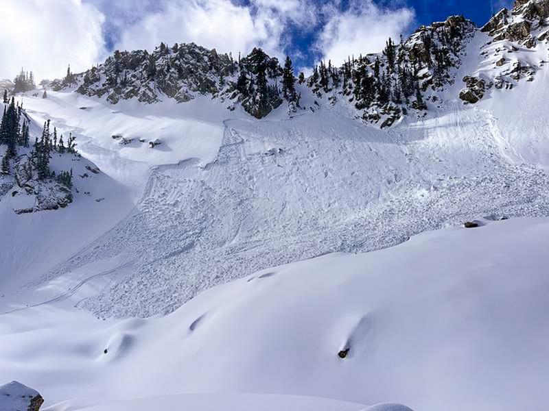
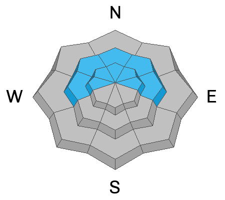
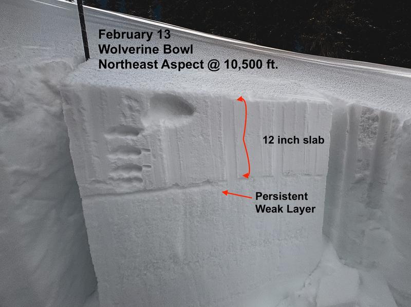
A tricky MODERATE avalanche danger exists in the mid and upper elevations, and primarily on slopes with previous deposits of wind-drifted snow. You can trigger soft slabs up to 2 feet thick and more than 200' wide. These are conditions for avalanche accidents - avalanches on persistent weak layers (PWLs) are notoriously tricky and avalanches can be triggered from a distance.

With daytime temperatures and strong direct sunlight, avalanche danger may rise to MODERATE on the remaining aspects and elevations as the potential for wet snow avalanches increases throughout the day. Avoid travel on sunny slopes where snow has become wet and heavy. Wet snow avalanches can start small but quickly pick up speed and volume as they travel downslope.

Low
Moderate
Considerable
High
Extreme
Learn how to read the forecast here
Special Announcements

Join the UAC for the first "Stay and Play Avalanche Course" at Bear River Lodge in the Uintas, March 19th-22nd. This course is designed for snowmobilers by snowmobilers, where you will learn avalanche rescue, riding skills, and how to survive in the backcountry. Come enjoy all the luxury offerings at Bear River Lodge and improve your skills along the way.

You can find details and sign up HERE.

Weather and Snow

This morning, skies are clear with temperatures between 15 and 20 °F, and winds are blowing from the west, averaging 5–10 mph with gusts in the 20s at 11,000 feet.

Today, high thin clouds build overhead through the afternoon. Temperatures warm into the low 40s °F, and southwest winds will increase to 10–20 mph with gusts in the 30s by early evening.

A series of storms will bring heavy mountain snow Monday night through Thursday, with the first wave dropping snow levels below 5,000 ft and adding 8 to 16 inches, followed by a second wave midweek bringing lighter, drier snow.

The Week in Review for Friday, February 6th - Thursday, February 12th, 2026 is hot off the press.

Recent Avalanches

Yesterday, several human-triggered avalanches were reported in the backcountry, with rumors of two close calls in terrain near Brighton.

Avalanche activity over the last several days has been most common on upper-elevation north through east-facing slopes where wind deposited additional snow. All of these soft slabs failed at the new/old interface, where exceptionally weak faceted snow remains from the January drought. These slopes may not appear obviously wind-loaded, as snowfall on Thursday fell with little wind and covered up the usual indicators of wind-drifting.

  • White Pine-Dog Dish- northeast aspect at 9600 feet, skier-triggered, 15 inches deep by 200 feet wide, failing on facets and propagating wide. See photo below.
  • Brighton- Pioneer Peak- northeast aspect at 10,200 feet, snowboarder-triggered, 12 inches deep by 50 feet wide, failing on facets.
  • Park City Ridgeline-Scotts Hill- north aspect at 9900 feet, skier-triggered, 2 feet deep by 25 feet wide, failing on facets.

While the recent storm snow has begun to settle and sensitivity slowly decreases, the slab is now more cohesive and has shown it can propagate widely.

A skier-triggered avalanche in upper White Pine failed on a layer of faceted snow and propagated widely.

You can view all recent observations here.

Avalanche Problem #1
Persistent Weak Layer
Type
Location
Likelihood
Size
Description

Recent storm snow buried weak facets from the January dry spell, creating a tricky slab problem. Avalanches 8 to 18 inches deep are being reported daily and are propagating wider as the snow settles and the slab stiffens. Some of these avalanches have even been triggered from a distance.

Slopes where the wind drifted additional snow, into a cohesive slab above the layer of sugary facets, are the most dangerous. The usual signs of wind-drifting we normally look for may not be obvious, as the most recent snow fell with very little wind. Avalanches breaking up to 2 feet deep and more than 200 feet wide are possible. These avalanches are large enough to catch, carry, and bury a rider. This structure is easy to identify with the naked eye if you dig down just a couple of feet. See example below.

While the problem is most pronounced on northerly aspects, the underlying weak structure is widespread and exists across the northern half of the compass, from west through east. On some slopes, existing crusts have helped to shoulder this initial load, but with additional snowfall expected next week, the problem is likely to become more significant and widespread.

Yesterday, Jess Shade and I traveled along the Wolverine Cirque and found the weak snowpack structure. View our observation HERE.

Avalanche Problem #2
Wet Snow
Type
Location
Likelihood
Size
Description

Warm daytime temperatures and strong sun may create conditions for wet snow avalanche through the day. Slopes where surface snow has become wet and heavy are where you can trigger a wet snow avalanche. These avalanches may start small and be slow-moving, but can quickly pick up speed and grow in size as they begin to slide downhill and entrain more snow.

Avoid terrain traps like chutes, gullies, and cliffs where small avalanches can increase consequences and pile up significant avalanche debris.

Additional Information

Learn more about Persistent Weak Layers in the video above -

General Announcements

This information does not apply to developed ski areas or highways where avalanche control is normally done. This forecast is from the U.S.D.A. Forest Service, which is solely responsible for its content. This forecast describes general avalanche conditions and local variations always occur.