Forecast for the Salt Lake Area Mountains

Bo Torrey
Issued by Bo Torrey on
Sunday morning, February 15, 2026

A MODERATE avalanche danger exists on mid-and upper-elevation slopes facing W-N-E. You can trigger a large soft slab avalanche that breaks 2 feet deep and up to 200 feet wide. The most concerning slopes are where strong winds blowing from the south have drifted additional snow.

Be aware of potential wet-snow avalanches throughout the day, and avoid traveling on steep slopes where you find wet, heavy snow.

Low
Moderate
Considerable
High
Extreme
Learn how to read the forecast here
Special Announcements

Join the UAC for the first "Stay and Play Avalanche Course" at Bear River Lodge in the Uintas, March 19th-22nd. This course is designed for snowmobilers by snowmobilers, where you will learn avalanche rescue, riding skills, and how to survive in the backcountry. Come enjoy all the luxury offerings at Bear River Lodge and improve your skills along the way.

You can find details and sign up HERE.

Weather and Snow

Overnight, clouds moved in, temperatures warmed, and the wind blowing from the southwest increased.

This morning, the skies are mostly cloudy, with trailhead temperatures hovering near freezing and upper elevation temperatures in the mid-20s °F. Winds are blowing out of the southwest 15-30 mph with gusts into the 50s mph.

Today, we’ll see mostly cloudy skies, with daytime temperatures reaching the upper 30s or low 40s °F, and winds blowing from the southwest remain steady at 15-25 mph with gusts in the 40s at upper elevations.

Outlook: A significant winter storm arrives late Monday, bringing the first in a series of powerful systems. By Thursday, storm totals could reach 30+ inches of snow with 2.0-3.0” SWE. Heavy snowfall and very strong winds, combined with a preexisting weak layer from the January dry spell, will create very dangerous backcountry avalanche conditions.

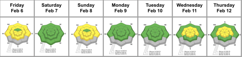
The Week in Review for Friday, February 6th - Thursday, February 12th, 2026, is hot off the press.

Recent Avalanches

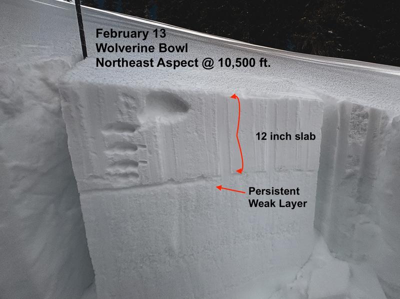
Yesterday, just outside of the Brighton area boundary along Pioneer Ridge, a snowboarder triggered a 1-to 2-foot-deep soft slab avalanche that broke on facets. The avalanche broke on a wind-drifted, northeast-facing slope at 10,000 feet. You can view the observation HERE.

Ski area teams hunting for avalanches in the Upper Cottonwoods triggered one very large, slab avalanche that broke on faceted snow. The avalanche occurred on a north-facing slope at 10,200 feet, under a cliff band.

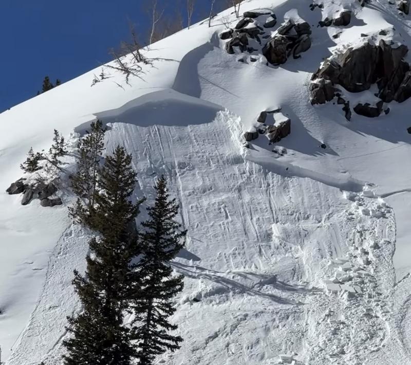
A snowboard-triggered avalanche near Brighton, on a northeast-facing slope at 10,000 feet. HERE.

You can view all recent observations here.

Avalanche Problem #1
Persistent Weak Layer
Type
Location
Likelihood
Size
Description

Recent storm snow buried a layer of weak facets from the January dry spell, creating a slab problem. Avalanches 1 to 2 feet deep continue to be reported. While overall activity has decreased as the snow settles, it's led to a stiffer slab that's demonstrated it can propagate widely.

Although yesterday's warm temperatures likely formed melt-freeze crusts on sunny slopes, strong winds can sometimes scour and drift a surprising amount of snow. Be vigilant for signs of fresh wind loading and avoid slopes where recent wind-drifting has occurred. Textured snow surfaces or changes in surface hardness are obvious signs that wind has affected the area.

The problem is most pronounced on northerly aspects, but the underlying weak structure is widespread and exists across the northern half of the compass, from West through East. On some slopes, existing crusts have helped to shoulder this initial load; however, with additional snowfall expected next week, the problem is likely to become more significant and widespread.

On Friday, Jess Shade and I traveled along the Wolverine Cirque and found a settled soft slab sitting above a widespread layer of facets in a wind-sheltered area. View our observation HERE.

Additional Information

Learn more about Persistent Weak Layers in the video above -

General Announcements

This information does not apply to developed ski areas or highways where avalanche control is normally done. This forecast is from the U.S.D.A. Forest Service, which is solely responsible for its content. This forecast describes general avalanche conditions and local variations always occur.