Avalanche Watch
What: Heavy snowfall and strong winds are expected to rapidly increase avalanche danger across northern and central Utah beginning Tuesday and continuing through the week. Forecasters at the Utah Avalanche Center expect dangerous and complex avalanche conditions to develop on many slopes, with large natural and human-triggered avalanches likely.
When: The Avalanche Watch is issued on Monday, 2/16/26 at 6:00 AM MST through 6:00 AM MST Tuesday, 2/17/26.
Where:
The Avalanche Watch is for the mountains of Northern, Central, and Southwestern Utah as well as Southeastern Idaho, including:
Impacts:
-
Dangerous avalanche conditions are expected to develop on many slopes.
-
Avalanches can be triggered on slopes steeper than 30 degrees. They may also be triggered remotely (from a distance) or from below.
What to do:
-
Avoid traveling on or underneath steep terrain at mid and upper elevations in the backcountry.
-
Carry and know how to use avalanche rescue equipment, including a transceiver, shovel, and probe.
-
Find safer riding conditions on slopes less than 30 degrees with no overhead hazard.
For updated avalanche information, visit www.utahavalanchecenter.org.
Join the UAC for the first "Stay and Play Avalanche Course" at Bear River Lodge in the Uintas, March 19th-22nd. This course is designed for snowmobilers by snowmobilers, where you will learn avalanche rescue, riding skills, and how to survive in the backcountry. Come enjoy all the luxury offerings at Bear River Lodge and improve your skills along the way.
You can find details and sign up HERE.
5 am: Skies are partly cloudy and temperatures are in the mid 20's °F. Winds are blowing from the south/southwest and strong, with gusts of 30-45 mph along exposed slopes and ridges at the mid and upper elevations. 11,000 foot wind speeds are gusting in the 70's mph.
Today: Skies will become mostly cloudy with temperatures in the mid to upper 30's °F. Winds will increase throughout the day.
Tonight and into Tuesday: Strong winds, with gusts over 50 mph along exposed mid and upper-level ridges. 11,000 foot winds will approach 100 mph. Heavy snowfall overnight and into Tuesday, with up to a foot by late Tuesday.
Heavy snowfall is expected again Wednesday and Thursday, with snowfall totals likely exceeding three feet by later Thursday.
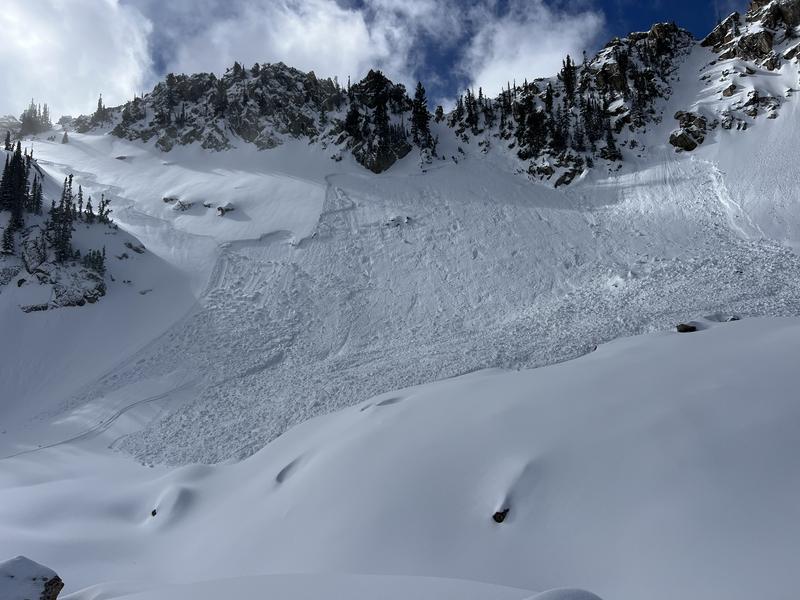
No new avalanches were reported from the backcountry on Sunday, although we continued to receive reports of recent avalanches from Wednesday's snowfall, including Friday's skier-triggered avalanche in White Pine (photo below) that failed on the January persistent weak layer that was two feet deep and over 200 feet wide.
You can view all recent observations here.