Forecast for the Salt Lake Area Mountains

Brooke Maushund
Issued by Brooke Maushund on
Tuesday morning, February 17, 2026

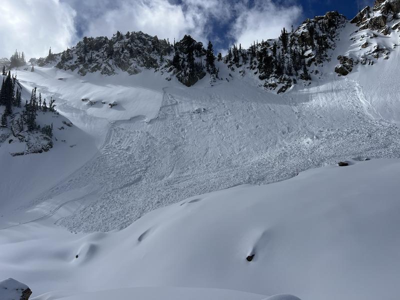
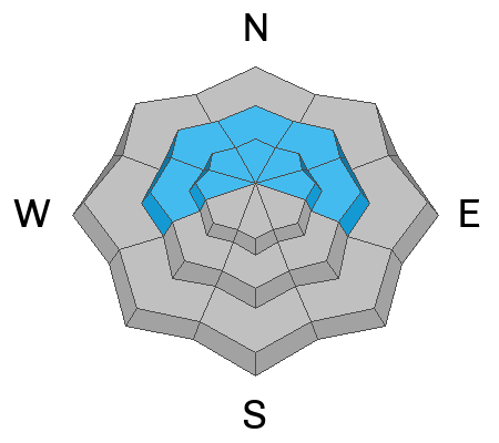
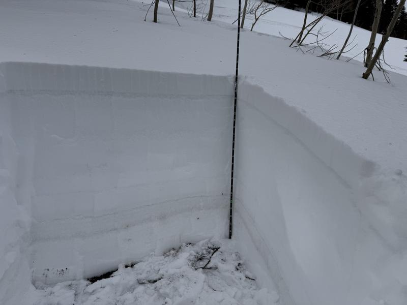
CONSIDERABLE avalanche danger exists on mid and upper-elevation slopes facing W-N-E where it is possible to trigger avalanches more than 1-2 feet deep failing on a buried persistent weak layer (PWL). A winter storm with snow and strong winds from the S will continue to load these slopes throughout the day, making it most likely to trigger a slide on slopes exposed to the wind. MODERATE danger exists on most other slopes.

The Utah Avalanche Center extended our Avalanche Watch as the storm continues to raise avalanche danger through the day and this evening.

Low
Moderate
Considerable
High
Extreme
Learn how to read the forecast here
Avalanche Watch

What: Heavy snowfall and strong winds are increasing avalanche danger across the mountains of Northern and Central Utah, as well as Southwestern Utah and Southeast Idaho. Forecasters at the Utah Avalanche Center expect dangerous, complex avalanche conditions to develop on many slopes this week, with large natural and human-triggered avalanches likely.

When: This Avalanche Watch is issued on Tuesday, 2/17/26 at 6:00 AM MST through 6:00 AM MST Wednesday, 2/18/26.

Where: The Avalanche Watch is for the mountains of Northern, Central, and Southwestern Utah, as well as Southeastern Idaho.

Impacts:

  • Dangerous avalanche conditions are expected to develop on many slopes.

  • Avalanches can be triggered on slopes steeper than 30 degrees. They may also be triggered remotely (from a distance) or from below.

What to do:

  • Avoid traveling on or underneath steep terrain at mid and upper elevations in the backcountry.

  • Carry and know how to use avalanche rescue equipment, including a transceiver, shovel, and probe.

  • Find safer riding conditions on slopes less than 30 degrees with no overhead hazard.

For updated avalanche information, visit www.utahavalanchecenter.org

Special Announcements

Avalanche Watch vs. Warning: The UAC issued our first Avalanche WATCH of the season yesterday and extended it through tomorrow morning. We issue WATCHs when we believe the criteria for an Avalanche WARNING—the most severe avalanche alert product we have—may be met in the next 24-48 hours. More info on each of these from Bruce Tremper and Drew Hardesty HERE.

Bear River Lodge "Stay and Play Avalanche Course": March 19th-22nd in the Uintas. This course is designed for snowmobilers by snowmobilers, where you will learn avalanche rescue, riding skills, and how to survive in the backcountry. Come enjoy all the luxury offerings at Bear River Lodge and improve your skills along the way. Details and sign up HERE.

Weather and Snow

Last night, the first in a series of storms arrived on SW flow. Temps dropped from the high 20s F to mid teens F overnight. Winds ripped out of the SW across the highest ridgelines in the 30-40s mph, reaching 96mph on Hidden Peak. The front of this first storm moved through quicker than expected, dropping less precipitation than forecast—but don't fret.

This morning, mountain temps are in the low to mid teens F, and strong SW winds continue. Storm boards in the upper Cottonwoods are showing: 2-4 inches of dense snow/graupel and 0.4-0.6 inches H2O as of 0400. The Park City Ridgeline looks to have about half of these totals.

Today into tonight, a series of small storms will bring on and off snow showers. SW winds will decrease throughout the day to 20-30s mph, and temps will be in the mid to high teens F. We can expect:

  • Upper LCC: 6-9" snow and 0.4-0.6" H2O by 5 pm tonight // An additional 9-12" snow and 0.7-0.9" H2O by 5 am tomorrow
  • Upper BCC: 4-7" snow and 0.3-0.7" H2O by 5 pm // 8-11" snow and 0.6-0.8" H2O by 5 am
  • PC Ridgeline: 3-6" snow and 0.3-0.5" H2O by 5 pm // 6-9" snow and 0.4-0.06" H2O by 5 am

Looking ahead, the cold front moves in tonight into early tomorrow morning. We can expect a shift to NW flow that favors the Cottonwoods for tomorrow into Thursday. This next pulse promises to be colder and bring lighter, lower-density snow. We are back in business.

Recent Avalanches

No new avalanches were reported from the backcountry on Monday although we continued to receive reports of recent avalanches from Wednesday's snowfall, including Friday's skier-triggered avalanche in White Pine (photo below) that failed on the January persistent weak layer that was two feet deep and over 200 feet wide.

You can view all recent observations here.

Avalanche Problem #1
Wind Drifted Snow
Type
Location
Likelihood
Size
Description

Wind-drifted snow: 3-4 inches of new snow fell overnight, and we can expect another 6-9 inches in favored areas by sunset. This came in on winds out of the SE shifting to the SW blowing 30-40mph consistently. Winds will stay at consistent loading speeds today, continuing to build deeper and more sensitive slabs throughout the day.

You will be able to find wind slabs more than 1-2 feet deep near ridgelines and on exposed mid-elevation slopes facing W-N-E. Be on the lookout for drifts, dunes, pillows, and wind-textured surfaces as these are signs the wind has been at work. These will have the potential to break/propagated wider than expected, and possibly be triggered from a distance (remote triggering) as they may be built atop the weak snow that developed during our dry period in January...more on that below.

New snow: On protected mid- and low-elevation slopes, expect the possibility of avalanches of new snow breaking at the old interface. These will grow throughout the day. On higher, steeper slopes, it will become increasingly possible to trigger loose-dry sluffs of new snow.

Avalanche Problem #2
Persistent Weak Layer
Type
Location
Likelihood
Size
Description

Our last significant snowfall was on January 9—more than a month ago. The snowpack weakened, or faceted, significantly since, with close to 2-3 feet of weak snow in some locations. The Dry January Layer (DJL), as you named it through our poll, can be found on upper and mid-elevation W-N-E facing slope. The DJL had 2-5 inches of low-density snow atop it from last week's storms, but it wasn't causing too many slides (yet) due to the lack of a slab.

Now, the series of storms that started last night are certain to build hefty slabs on top of the very weak DJL, with forecast snow totals reaching into 3 feet by late this week. This strong over weak structure will be likely to produce large, destructive avalanches big enough to bury and kill a person. As the storm carries on into the day, expect these to increase in size and likelihood.

These will become more sensitive the larger the slab builds atop them, meaning wind-loaded slopes mentioned above are most suspect. Expect these to be able to propagate widely, and potentially be triggered from a distance away (remote-triggering).

The DJL is evident in the gray stripe shown in the photo below from Days Fork on Sunday.

Additional Information

Learn more about Persistent Weak Layers in the video above -

General Announcements

This information does not apply to developed ski areas or highways where avalanche control is normally done. This forecast is from the U.S.D.A. Forest Service, which is solely responsible for its content. This forecast describes general avalanche conditions and local variations always occur.