UDOT PLANNED AVALANCHE CLOSURES!!

Forecast for the Provo Area Mountains

Trent Meisenheimer
Issued by Trent Meisenheimer for
Saturday, March 9, 2019
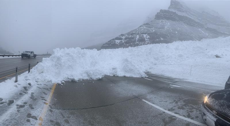
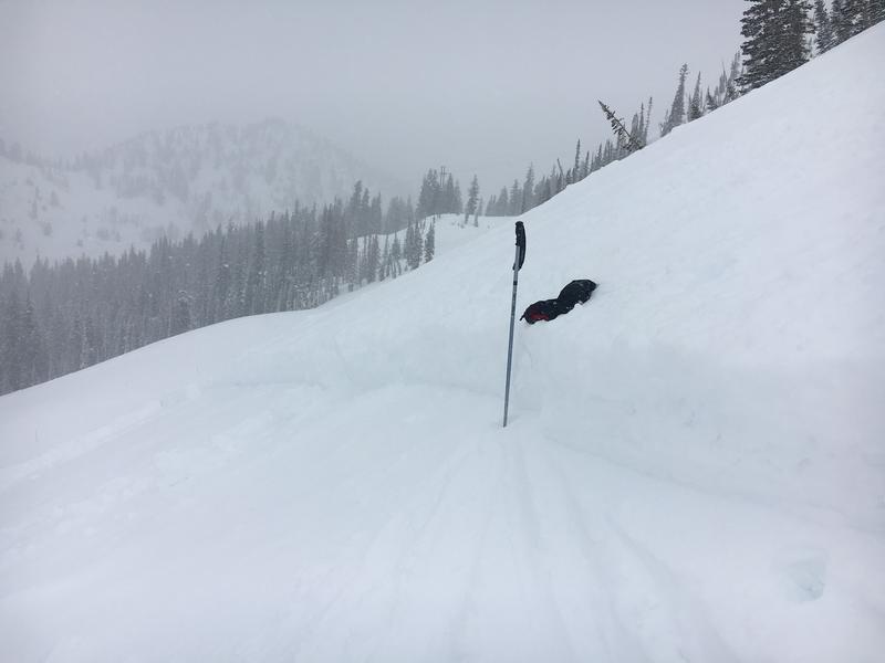
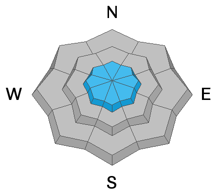
The avalanche danger is CONSIDERABLE at all mid and upper elevation slopes. New snow avalanches 1 to 3 feet deep can be triggered, along the ridge lines and mid slope. It's also possible to trigger a much larger and deeper slide that breaks into deeper weak layers on aspects facing northwest through southest at the mid and upper elevations. Use cautious route finding and conservative decision making today.
The warm, new snow instabilities strengthen quickly, have patience for just a day or two before stepping into bigger, sustained steep terrain. For now, the vast untracked acres of surfy snow on lower angled slopes offer a much lower danger.
Low
Moderate
Considerable
High
Extreme
Learn how to read the forecast here
Special Announcements
Greg’s Week in Review has arrived! Check it out here.
Weather and Snow
Yesterday's cold front rolled through the mountains around 3:00 pm dropping the temperatures, and stacking up some amazing champagne powder with a dense and bouncy base underneath. On our third run of the day my dad was covered head to toe in powder, smiled, and said " that's why I live in Utah! "
24 hr Snow totals are as follows:
Provo Area: 14.5" snow (1.03" h20)
Upper LCC: 13"-17" snow (0.76"-1.22" h20)
Upper BCC: 9"-17" snow (0.58"-1.07" h20)
Park City Ridge: 6"-10" snow (0.5"- 0.75" h20)

Total storm snow since March 5th:
Provo Area: 26.5" snow (4.04" h20)
Upper LCC: 29"-35" snow (2.53"-2.95" h20)
Upper BCC: 31"-38" snow (2.48"-3.46" h20)
Park City Ridge: 17.5"-20" snow (0.65"- 2.0" h20)

Under partly to mostly cloudy skies this morning the snow is starting to slow down. Winds are from the westerly direction and are currently blowing 15-20 mph gusting into the low 20's at 11,000'. Lose some elevation and the winds are blowing 5-10 mph at the mid elevations. Current mountain temperatures are in the mid teens °F while the lower trail heads sit in the upper teens. We have a slight chance of clearing this morning before thicker clouds stream in overhead from the west. Snow showers will be off and on throughout the day with 1-3" of new snow possible. Winds are not expected to increase.
Recent Avalanches
Yesterday afternoon we went through a widespread new snow avalanche cycle around 3:00 pm as the snowfall intensity increased. Numerous slide paths in upper LCC released naturally and some ran 2,000' vertical feet. In Provo canyon a natural avalanche out of slide canyon hit and closed the road (pic below).
At least three skiers reported taking rides in avalanches yesterday (partially buried with no injuries). The first one happened at Cardiff Pass the other in the Ogden backcountry, and another off Patsey Marley in upper LCC. Both the Cardiff and Ogden avalanches were 2' deep and 100' wide, failing within the storm snow. The Patsey Marley slide had no details other than they lost gear and were uninjured. Numerous observers took note of sensitive soft slab avalanches that were 6-12" deep and up to 100' feet wide. The new snow was easily moving once disturbed by a rider and loose snow avalanches were moving fast and far and leaving debris piles deep enough to bury a human.
A list of all recent avalanche activity can be found HERE.
Photo: Natural Avalanche in Provo Canyon. (PC: Leonard)
Ad
Avalanche Problem #1
New Snow
Type
Location
Likelihood
Size
Description
Expect new snow soft slabs and loose snow avalanches to be easily triggered by the weight of a human today. These new snow avalanches are failing within either the storm snow (on stellars), graupel pools or at the old/new snow interface. You can expect any of these avalanches to be 1-3' deep and 100-300' feet wide, large enough to bury you. The loose new snow is running fast and far and is easily triggered in any terrain steeper than 35° degrees in steepness.
The good news: the new snow should stabilize quickly. However, I am not expecting it will be stable today. We need to be patient and let the new snow settle and gain some strength before we step out into bigger terrain. Use low angle terrain features, ridges or high points if you're going to travel in the backcountry today and know that conservative decision-making is essential. Travel one at a time and keep an eye on your partner and be ready to help if anything goes wrong.
Photo: Craig Gordon looking at the soft slab that was triggered in the Brighton Backcountry.
Avalanche Problem #2
Wind Drifted Snow
Type
Location
Likelihood
Size
Description
Overnight the northwest winds picked up for a brief 6-8 hr period and blew 15-20 mph gusting into the 30's at upper elevations. This morning the winds have died down and are not expected to increase throughout the day. However, with so much new snow available to transport you can't rule out wind drifts and slabs of snow on the steep, upper elevation, lee aspects. Look for and avoid pillowy, rounded snow. If you find yourself in wind drifted terrain it will only increase the size of the avalanche and it will likely be 2-4' deep and could be several hundred feet wide.
Avalanche Problem #3
Persistent Weak Layer
Type
Location
Likelihood
Size
Description
The Provo mountains have had a number of large avalanche cycles in January and February with many avalanches stepping down into early season or mid-December snow layering 3-8' deep. These avalanches were predominantly in the upper elevation (or wind loaded ridgelines in the mid-elevation) north through southeast facing slopes both along the Cascade ridgeline, Timpanogos, and in the upper American Fork drainages (Mill Canyon Peak environs).
These areas that avalanched remain susceptible to continued avalanching in the upper elevations that have seen significant snow and wind. The large avalanches in the UFO Bowls north of Aspen Grove (from the 3rd week of February) did not seem to have enough of a new load yesterday but will be something to watch with additional storms this week.
Note: assessing these slopes individually requires a high degree of skill and experience and risk....and may still produce some uncertainty. A very conservative approach is required if traveling in the avalanche terrain of Provo.
Mt Nebo area: Although outside of our forecast zones, Mark and I rode along the Mt Nebo Scenic Loop on Tuesday and found similar conditions to areas further north. Read our full observation HERE.
Additional Information
It's March - if the clouds thin or the sun comes out for any time today keep an eye on the snow surface as it could become damp and loose wet avalanches could become an issue. If you're seeing roller balls cascading down the hill it's time to get out of there.
General Announcements
This information does not apply to developed ski areas or highways where avalanche control is normally done. This forecast is from the U.S.D.A. Forest Service, which is solely responsible for its content. This forecast describes general avalanche conditions and local variations always occur.