Observation Date
3/5/2019
Observer Name
Meisenheimer / Staples
Region
Provo » Mt Nebo
Location Name or Route
Santaquin Canyon to Nebo Loop Rd.
Comments
Seeing the recent natural avalanche off the east side of North Peak (north of Nebo) is enough information for us. The recent slide (picture 1) looks to be 300' wide 6-8' deep to the ground and ran 2,300' vertical feet down hill. The arrow on the right hand side of the photo shows this avalanche. The red outline was another avalanche that likely occurred in mid February sometime and is now filling back in. We measured this avalanche on Google Earth and the red outline is 1,900' with a maximum width of 900' feet. Areas that have previously avalanched like in this photo should be treated as no go terrain. See Wilson/Hardesty observation from the Provo area on repeater slide paths HERE.
Anytime, there is a full depth avalanche the snowpack resets to ground zero. If it stays shallow and cold you can expect weak snow to be there. With the storm approaching tonight and into tomorrow you could assume there is weak snow in any path that has previously avalanched. To complicate the issue - you will no longer be able to see the old crowns and it will become virtually impossible to know which slopes have avalanched and which ones have not.
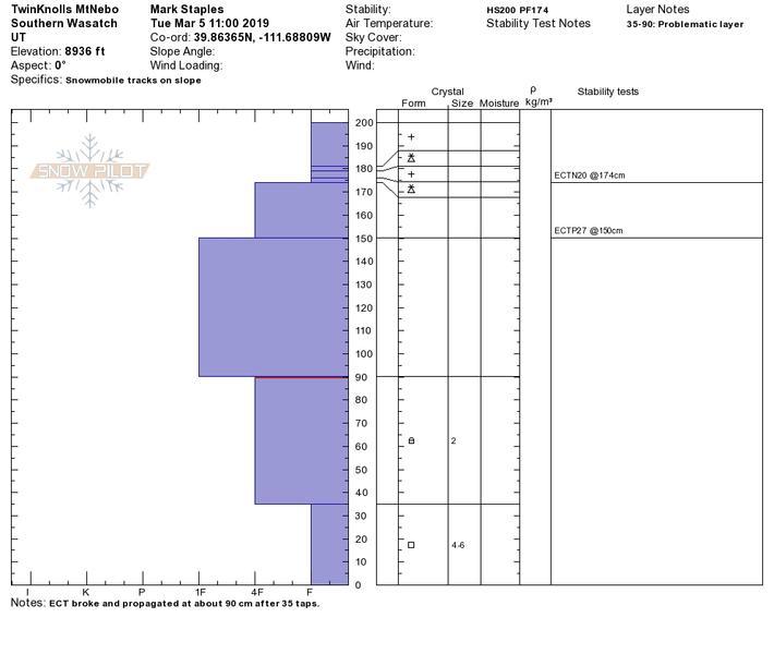
Picture 3 - Trent pointing at the two weak layers that propagated in our tests.


Another large recent avalanche was spotted one bowl south of Middle Basin. This looked to be confined to the new snow (mid pack) and was likely 2-4' deep and roughly 1,300' feet wide running 3,400' vertical feet.

Mark looking at the snowpack on a NE facing slope at 8,200' in elevation on the shoulder of Dry Mountain. Here we found a pretty solid snowpack with a good structure.

Today's Observed Danger Rating
Moderate
Tomorrows Estimated Danger Rating
Considerable
Coordinates


