Forecast for the Provo Area Mountains

Drew Hardesty
Issued by Drew Hardesty for
Sunday, March 10, 2019
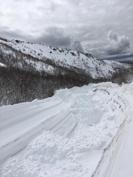
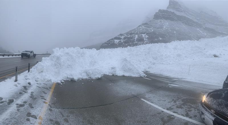
The avalanche danger is CONSIDERABLE at many mid and upper elevation slopes. New snow avalanches 1 to 3 feet deep can be triggered, along the ridge lines and mid slope. It's also possible to trigger a much larger and deeper slide that breaks into deeper weak layers on aspects facing northwest through north through southeast at the mid and upper elevations. Use cautious route finding and conservative decision making today. Low elevations are included as they may be beneath larger runout zones.
If the sun or greenhousing manifests, wet avalanches are to be expected.
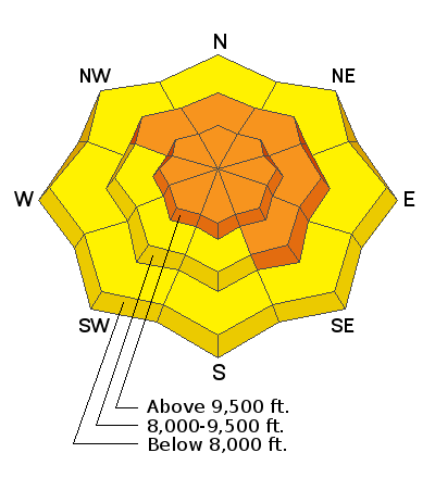
Low
Moderate
Considerable
High
Extreme
Learn how to read the forecast here
Special Announcements
Greg’s Week in Review has arrived! Check it out here.
Weather and Snow
Happy Daylight Savings.
Skies are overcast with light snow falling in the mountains. Under the spell of a weak warm front, most areas have picked up a trace to 2" overnight with slowly warming temperatures (mid-20s) and mercifully light winds from the south. The cool, shady terrain will still have 5 star riding but some southerlies will have a breakable sun crust beneath the new.
Recent storm snow since March 5th: 26.5" snow (4.04" h20)
It's been a good run this winter with much of the state well above average- see below (courtesy of our partners here at the Colorado Basin River Forecast Center - we share an office with them at the NWS)
For the next couple days, we can expect overcast to mostly cloudy skies, light southerly winds and a warming trend toward the upper 20s along the ridgelines. A weak storm system arrives Tuesday night into Wednesday which should be good for another 4-8" of snow. Get it while you can. Models suggest high and dry late week into the weekend...and beyond -
Recent Avalanches
Friday afternoon we went through a widespread new snow avalanche cycle around 3:00 pm as the snowfall intensity increased. Numerous slide paths ran naturally with impressive debris piles noted off Timpanogos and in runout zones in Dry Creek above the town of Alpine near Box Elder Peak (pic below). I would suspect many repeater avalanche paths ran with the storm leaving large avalanches and debris piles in their wake.
Thanks to Joe Martel with his excellent report here -
Photo: Natural Avalanche in Provo Canyon from Friday. (PC: Leonard)
Ad
Avalanche Problem #1
New Snow
Type
Location
Likelihood
Size
Description
You can still trigger an avalanche within the recent storm snow on a variety of structural interfaces up to and over two feet deep today. Failure planes may include graupel, early storm low density snow, and on sun and rain crusts. Absent the tell-tale signs of instability (cracking, collapsing), it's worth pulling out the shovel and performing a few snow tests to gather info on the snow that you're keen to ski or ride. Use test slopes (steep but low consequence terrain) to help gather info for representative terrain.
A couple of fine points for today:
Graupel (pellet snow) can be a significant weak layer as it often runs downhill and pools at the base of cliff bands or on clear transitions from steep to less steep terrain. It's not uncommon to successfully descend a couloir only to trigger the pocket in the aprons or more benign terrain below.
Sluffing today is possible in the steepest terrain and may be more likely and problematic on the steep southerly aspects today. Weak snow may have developed above yesterday's sun crusts and this may aid and abet any of the sluffing on these slopes.
Cornices are generally too large to tangle with and remain highly suspect. Remember 5% of our avalanche fatalities involve cornice fall.
Avalanche Problem #2
Persistent Weak Layer
Type
Location
Likelihood
Size
Description
I suspect many avalanches stepped down into older weaker layers leftover from previous avalanche events from January and March. These may have been many feet deep and hundreds of feet wide and most likely on northwest to northeast to southeast facing slopes at the mid and upper elevations. As one can see from the photos, these avalanches have - and can still - run quite far even into assumed safe terrain. The Provo snowpack remains dangerous on many aspects and elevations. Even very experienced people are giving a wide buffer of margin in this terrain. These are difficult and dangerous conditions to assess - from Cascade to Box Elder to Timp to the southern Wasatch Back (Snake Creek to Mill Canyon Peak).
General Announcements
This information does not apply to developed ski areas or highways where avalanche control is normally done. This forecast is from the U.S.D.A. Forest Service, which is solely responsible for its content. This forecast describes general avalanche conditions and local variations always occur.