Forecast for the Provo Area Mountains

Evelyn Lees
Issued by Evelyn Lees for
Friday, March 8, 2019
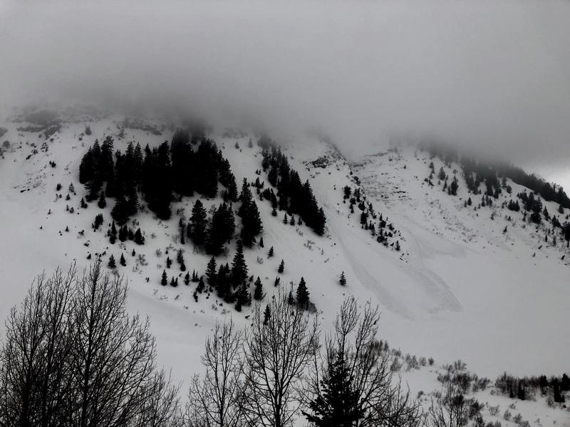
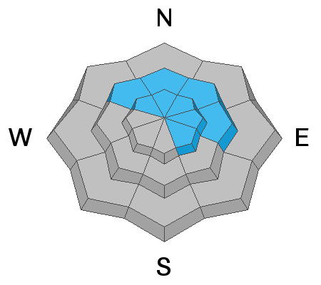
The avalanche danger is HIGH at the upper elevation slopes and mid elevation slopes. Natural avalanches are occurring as the storm is producing more snow than expected. Triggering a wind drift or new snow slide is certain in steep terrain. The avalanche danger will remain HIGH this afternoon during frontal passage and as long as it snows heavily or the winds pick up. Slides can run long distances in the continuously steep terrain in the Provo area mountains. Backcountry travel in avalanche terrain is not recommended. Avoid avalanche run out zones even at the mid and low elevations.
Low
Moderate
Considerable
High
Extreme
Learn how to read the forecast here
Special Announcements
Greg’s Week in Review has arrived! Check it out here.
Weather and Snow
Under a light southwest flow, the Provo area mountains picked up 1 to 2" of snow overnight at the mid elevations. Storm totals are now about a foot of snow, with over 3" of water, a combination of snow and rain. The southwesterly winds are light this morning - averaging 5 to 15 mph, gusting 20 to 25 mph at the mid elevations. The high 11,000' peaks to the north have gusted the 30s and 40s over the past few hours. Temperatures are in the mid to upper 20s and .have finally cooled below freezing even at the lower elevations.
Today: continued light to moderate snow, with the cold front arriving this afternoon. Snow through early this afternoon will be heaviest in areas favoring southwest flow, with 4 to 9” possible. The cold front arriving this afternoon will bring a period of heavier snow, continuing into the overnight hours, with an additional 1 to 4” overnight possible.
Winds will remain from the southwest, averaging 10 to 20 mph at times, with gusts to 30. Highest peaks will only average 25 mph, with gusts to 35.
Temperatures will continue their cooling trend, and remain in the low twenties today at 10,000’, before dropping into the teens tonight.
Recent Avalanches
No new observations from the Provo area mountains. Here's what happened to the north:
There were numerous triggered slides in the backcountry and at the resorts yesterday, with people taking a couple of short rides. The largest was a very connected slide on Lake Peak, in White Pine about a foot deep by 1/3 to a 1/2 mile wide, running 1000' vert.
Slides involving graupel as the weak layer broke in pools below cliff bands and propagated on to lower angle slopes. Pioneer Ridge, 2' deep x 300' wide.
Shallow, new snow slides averaging 6-10" deep and 80 to 100’ wide were triggered in Days, Silver Fork, Figure 8 Hill and Rocky Point, including Jaws and Doug’s Drop. A wind slab triggered on Benson Hedges turned wet as it moved downhill.
A couple larger natural slides broke into the weak snow from the weekend in White Pine and S Monitor, 10 to 20” deep and 300 feet wide. Greg Gagne checked out the White Pine slide.
Wet loose sluffs ran at the low to mid elevations in the Provo area mountains Wednesday.
Provo: natural wet loose sluffs in the Fingers on Timpanogos, 7,400’, NE, Shannon Finch photo
Numerous roofs avalanched yesterday, dumping large loads of snow into deep dangerous piles. (Matt Rollins video) Warm temperatures mean roofs will continue to shed their snow - please alert your friends and family who may not normally check avalanche forecasts. Roof avalanches can be deadly especially for children.
Ad
Avalanche Problem #1
Wind Drifted Snow
Type
Location
Likelihood
Size
Description
A few periods of stronger south to southwesterly winds overnight and the past 48 hours created localized drifts, most widespread along the higher ridge lines, but also found mid slope. Identify and avoid the smooth, denser, rounded slabs of wind drifted snow. Large cornices continue to be sensitive with the added weight of the new snow on top. Stay way back from the edges as you travel along ridge lines, and don’t travel beneath them.
Even out of the wind affected terrain, weak layers within the new snow and poor bonding to the old snow surfaces means you can trigger new snow slides up to a foot deep. On the shady slopes, the new dense snow fell on weaker low density snow and on the sunny slopes it landed on a hard crust. The new snow will be most sensitive during any periods of intense snowfall. Jumping on small test slopes can help give you a feel for the bonding of the new snow.

The large cornices will be more sensitive today with the added weight of the new snow on top. Stay way back from the edges, and don’t travel beneath them.
Avalanche Problem #2
Persistent Weak Layer
Type
Location
Likelihood
Size
Description
The Provo mountains have had a number of large avalanche cycles in January and February with many avalanches stepping down into early season or mid-December snow layering 3-8' deep. These avalanches were predominantly in the upper elevation (or wind loaded ridgelines in the mid-elevation) north through southeast facing slopes both along the Cascade ridgeline, Timpanogos, and in the upper American Fork drainages (Mill Canyon Peak environs).
These areas that avalanched remain susceptible to continued avalanching in the upper elevations that have seen significant snow and wind. The large avalanches in the UFO Bowls north of Aspen Grove (from the 3rd week of February) did not seem to have enough of a new load yesterday but will be something to watch with additional storms this week.
Note: assessing these slopes individually requires a high degree of skill and experience and risk....and may still produce some uncertainty. A very conservative approach is required if traveling in the avalanche terrain of Provo.
Mt Nebo area: Although outside of our forecast zones, Trent and I rode along the Mt Nebo Scenic Loop yesterday and found similar conditions to areas further north. Read our full observation HERE.
Avalanche Problem #3
Wet Snow
Type
Location
Likelihood
Size
Description
Though temperatures have cooled, it will take time for the soggy snow at the low elevations to cool and strengthen. It will still be easy to get a wet loose sluff moving on steep slopes, especially during any periods of wet snow or rain. Avoid steep slopes with wet soggy snow, especially gullies, creek banks or road banks where even a small slide can pile up deep debris.
Additional Information
General Announcements
This information does not apply to developed ski areas or highways where avalanche control is normally done. This forecast is from the U.S.D.A. Forest Service, which is solely responsible for its content. This forecast describes general avalanche conditions and local variations always occur.