Donate to the 2024 Spring Campaign to help rebuild the UAC website.

Forecast for the Provo Area Mountains

Trent Meisenheimer
Issued by Trent Meisenheimer for
Sunday, December 2, 2018
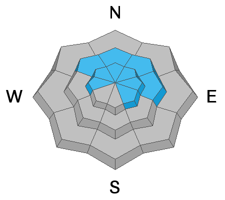
The avalanche danger is CONSIDERABLE on mid & upper elevation northwest through east facing terrain. Human triggered avalanches are LIKELY and you can expect avalanches to break 1-3' feet deep and several hundred feet wide. Avalanches can be triggered from a distance, from below and on slopes that have already slid this year.
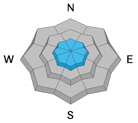
  • Safer options do exist on the south facing terrain or lower elevations where there is no weak faceted snow.
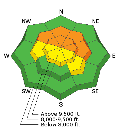
Low
Moderate
Considerable
High
Extreme
Learn how to read the forecast here
Special Announcements
We have a couple of fun events coming up on December 5th and 6th in Salt Lake and Park City. Topics include Recreating in New Zones, Women's Specific Avalanche Awareness, and a slide show from Ascent Magazine. More info about these events HERE.
Weather and Snow
It continues to snow in the mountains as a weak cyclonic (counter clockwise) circulation sets up over the west dessert. Overnight totals are 3-6" of low density new snow. Winds will remain light and from the northeast this morning, before switching to the northwest by this evening as this weak circulation moves downstream (east). The good news: this will likely bring 3-6" of champagne blower powder today and keep the riding and turning conditions all time. Current mountain top temperatures are in the mid teens °F while the mid elevation trail heads sit just below 20°F. Winds remain light and upper elevation anemometers are spinning 5-10 mph with the occasional gust into the teens.
  • Our first Week in Review where we summarize significant weather and avalanche activity from the previous week has been published.
Recent Avalanches
We went through another natural avalanche cycle in the overnight hours of November 30th and into the morning on December 1st. To the north in the SLC mountains - many large naturals were reported on Saturday by backcountry observers. Cracking and collapsing is widespread and many observers heard the thunderous, heart sinking, noise on their outings. Snow safety teams are still triggering avalanches into the old, weak, faceted snow. These avalanches are large enough to bury and kill a person. The avalanche list is HERE, with great info and excellent photos.
  • There was an observation from Joey Dempster from the Provo area found HERE.
Ad
Avalanche Problem #1
Persistent Weak Layer
Type
Location
Likelihood
Size
Description
The old faceted snow near the ground is really a bad deal. With a new load of snow and stiffer wind drifts, all the steep slopes with old, faceted snow are dangerous – human triggered avalanches are likely, and can be triggered from a distance, including from below. The higher you go in the Provo area mountains, the worse this problem is. With stiffer wind slabs added into the mix, avalanches may pull on to ridges or lower angle adjacent slopes.
Simply do not travel on or adjacent to slopes steeper than 30 degrees facing west though north through southeast at the upper elevations, and northwest through easterly at the mid elevations. Existing tracks are not an indication of stability, but rather of a rider who just got away with it.
Avalanche Problem #2
New Snow
Type
Location
Likelihood
Size
Description
With close to two feet of new snow and strong winds in the past 36 hrs you can't rule out - new snow sluffs and new snow soft slabs. This problem tends to stabilize rapidly and is easy to manage. However, this morning we need to continue using safe travel protocol. Waves or pillows of snow, denser thick snow, or cracking are all signs of new snow instability.
General Announcements
This information does not apply to developed ski areas or highways where avalanche control is normally done. This advisory is from the U.S.D.A. Forest Service, which is solely responsible for its content. This advisory describes general avalanche conditions and local variations always occur.