UDOT PLANNED AVALANCHE CLOSURES!!

Forecast for the Ogden Area Mountains

Mark Staples
Issued by Mark Staples for
Saturday, March 30, 2019
Today the avalanche danger is MODERATE. The main avalanche problem to watch for and avoid are fresh slabs of wind drifted snow.

As the day warms and if the sun appears for any notable length of time, watch for the snow becoming wet and producing loose wet avalanches.
Low
Moderate
Considerable
High
Extreme
Learn how to read the forecast here
Special Announcements
We need your help. In an effort to increase awareness and prevent future fatalities we need to reach more people with our daily avalanche forecasts, expand the Know Before You Go program, and increase the number of on-snow avalanche courses. Please consider a donation to the UAC to help us raise $25,000 by April 8. Help your support of the UAC by making a donation HERE. Thank you for your support!
Couple of new interesting things to read and listen to: (1) The latest blog by Drew "Roping the Wind (Slab)", and (2) UAC podcast featuring Lynne Wolfe - guide, avalanche educator, editor of The Avalanche Review, mentor, role model. This is a can't-miss episode!
Weather and Snow
Snow: A few more inches of snow fell yesterday afternoon. Total snow since Thursday night is 19 inches near Snowbasin (2 inches of water) and about 13 inches in other areas (1.2-1.4 inches of water).
Temperatures: This morning temperatures are mostly in the mid 20s F.
Winds: Yesterday ridgetop winds averaged 15 mph with gusts of 30 mph from the west. They were a bit calmer on the eastern side of the Ogden valley. This morning winds shifted to the east and were blowing 5-10 mph.
Today: Scattered snow showers will produce a trace to an inch of snow. Winds will remain mostly calm. Temperatures will climb into the mid to upper 30's F. There will be a mix of sun and clouds but it's hard to say exactly how much sunshine we'll see.

The new snow should have settled some overnight and I'd expect great "surfy" riding conditions this morning before the snow warms up too much.
Recent Avalanches
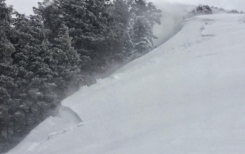
Two avalanches occurred in Hells Canyon just north of Snowbasin yesterday when two riders triggered one and then observed another avalanche descend next to them (maybe natural or maybe triggered by another party). Photo below shows the powder cloud of the slide that descended while they were in the runout zone.
At North Ogden Divide, I was able to easily trigger several slabs of wind drifted snow (photo below). Brian Smith triggered a few wet loose avalanches at low elevations.
Ad
Avalanche Problem #1
Wind Drifted Snow
Type
Location
Likelihood
Size
Description
Soft slabs of wind drifted snow from yesterday's westerly winds are the main avalanche problem today. These wind slabs are 1-2 feet thick. The trouble is that they will be stabilizing at different rates. Some may be stubborn and well bonded while others may remain sensitive and can still avalanche.
Video below of yesterday's winds at North Ogden Divide transporting snow.
Avalanche Problem #2
Wet Snow
Type
Location
Likelihood
Size
Description
Be heads up if the sun appears for any length of time and the snow starts getting wet. Sunshine is very strong this time of year. By afternoon the snow could get damp and snow quality should deteriorate. If the snow gets wet and you see pinwheels of snow rolling downhill, that is a sign that wet loose avalanches could start happening.
Avalanche Problem #3
Persistent Weak Layer
Type
Location
Likelihood
Size
Description
A buried weak layer may still exist on mid and upper elevation northerly facing slopes. Read more about people finding it observation1 and observation2.
Warmer temperatures this week may have helped heal this layer, and yesterday I couldn't find it near the North Ogden Divide at 7500 feet. However, it would be worth digging 2-3 feet down to look for this layer since it was just loaded.
General Announcements
This information does not apply to developed ski areas or highways where avalanche control is normally done. This forecast is from the U.S.D.A. Forest Service, which is solely responsible for its content. This forecast describes general avalanche conditions and local variations always occur.