| During the month of April, Mark Miller will donate $75 to the charity of your choice (5 to chose from, including the Utah Avalanche Center!) Mark Miller Subaru has raised over $300k in the previous 6 Do Good Feel Good events. More Info here |  |
| During the month of April, Mark Miller will donate $75 to the charity of your choice (5 to chose from, including the Utah Avalanche Center!) Mark Miller Subaru has raised over $300k in the previous 6 Do Good Feel Good events. More Info here | |
| Advisory: Uintas Area Mountains | Issued by Craig Gordon for Tuesday - March 3, 2015 - 5:37am |
|---|

|
bottom line At and above treeline on steep wind drifted slopes facing the north half of the compass, you'll find a CONSIDERABLE avalanche danger. Human triggered avalanches are likely and natural avalanches possible. Any slide triggered today has the potential to break deeper and wider than you might expect, resulting in a deep, dangerous slide. Mid elevation terrain offers MODERATE avalanche danger and human triggered avalanches are possible on steep wind drifted slopes. Most other terrain offers a LOW avalanche danger.
|
 |
current conditions Wow... March madness is in full swing and the region got slammed overnight with a nice shot of snow. Looks like an evenly distributed foot of snow fell at the upper elevations across the range. West and southwest winds ramped up Monday with hourly averages in the 30's and gusts in the 50's. With cold air filtering into the region, temperatures are in the mid teens this morning. Visibility will be an issue today for sure, especially with all the new snow flying over-the-hood and in your face! Click here for real-time temperatures, snowfall, and winds.
|
 |
recent activity While still manageable in size and depth, by late Monday fresh wind drifts were becoming more widespread and sensitive to the additional weight of a person. Dave Kikkert was stomping around Upper Weber Canyon and his take on conditions can be found here.
|
| type | aspect/elevation | characteristics |
|---|

|
|
LIKELIHOOD
 LIKELY
UNLIKELY
SIZE
 LARGE
SMALL
TREND
 INCREASING DANGER
SAME
DECREASING DANGER
|
|
description
The avalanche danger changed drastically overnight and for the moment, our days of Low danger and big terrain choices have gotta be put on hold. Fresh wind slabs are gonna be today's most obvious avalanche problem and it's because a cohesive layer of snow formed on top of the light, fluffy powder from this weekends storm. With more snow and wind on the way in the next couple hours, I bet today's slabs will break deeper and wider than you might expect and they'll be packing a punch. Today you'll want to avoid steep, wind drifted slopes, especially those facing the north half of the compass. Remember- shooting cracks are a big clue to unstable snow and you'll definitely want to avoid any fat, rounded pillows of snow. Lose a little elevation, head to mid elevation sheltered terrain and you'll be rewarded with deep snow and manageable avalanche danger.
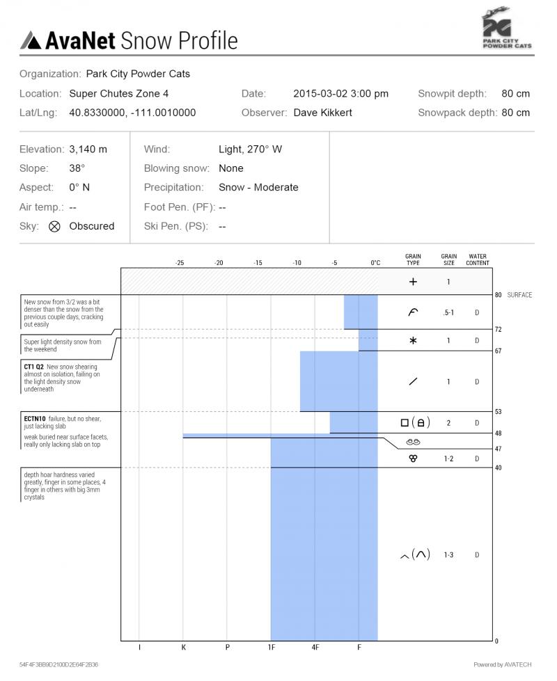
This might look like an ancient Egyptian scroll to some, but in the snow geek world it illustrates snowpack structure. Clif Notes version is... between 67 cm and 80 cm there's strong snow on weak snow and as you know... that's no es bueno.
|
| type | aspect/elevation | characteristics |
|---|

|

|
LIKELIHOOD
LIKELY
UNLIKELY
SIZE
LARGE
SMALL
TREND
INCREASING DANGER
SAME
DECREASING DANGER
|
|
description
While not widespread and hard to detect, there are pockets of sugary snow near the ground, especially in upper elevation terrain facing East, North, and Northeast. This storm has all the ingredients to bring those dormant weak layers back to life. Once triggered, today's avalanches have the potential to break to weak snow near the ground, particularly in steep, rocky terrain. A slide of this nature is gonna be deep, wide, and certainly unmanageable. With all the good options for riding today, there's no reason to pull on the dogs tail. A little patience goes a long way in the mountains... it's spring after-all and in a few days the avalanche danger will become more predictable. |
 |
weather Another wave of weather is setting its sights on the range and snowfall should start to increase in intensity during the morning hours. An additional foot of snow is possible before the storm winds down late this afternoon. West and southwest winds veer to the northwest with frontal passage and it'll be breezy along the ridges, with hourly averages in the 20's and 30's and a few gusts in the 40's. High temperatures don't vary much from where we're at this morning and under clear skies tonight, they dive to near zero. High pressure builds for the rest of the week.
|
| general announcements Remember your information can save lives. If you see anything we should know about, please participate in the creation of our own community avalanche advisory by submitting snow and avalanche conditions. You can call me directly at 801-231-2170, email [email protected], or email by clicking HERE This is a great time of year to schedule a free avalanche awareness presentation for your group or club. You can contact me at 801-231-2170 or email [email protected] Donate to your favorite non-profit –The Utah Avalanche Center. The UAC depends on contributions from users like you to support our work. Benefit the Utah Avalanche Center when you buy or sell on ebay - set the Utah Avalanche Center as a favorite non-profit in your ebay account here and click on ebay gives when you buy or sell. You can choose to have your seller fees donated to the UAC, which doesn't cost you a penny. Utah Avalanche Center mobile app - Get your advisory on your iPhone along with great navigation and rescue tools. The information in this advisory is from the US Forest Service which is solely responsible for its content. This advisory describes general avalanche conditions and local variations always occur. I will update this advisory by 7:00 AM Wednesday Mar. 4, 2015. |


_0.jpg)