| During the month of April, Mark Miller will donate $75 to the charity of your choice (5 to chose from, including the Utah Avalanche Center!) Mark Miller Subaru has raised over $300k in the previous 6 Do Good Feel Good events. More Info here |  |
| During the month of April, Mark Miller will donate $75 to the charity of your choice (5 to chose from, including the Utah Avalanche Center!) Mark Miller Subaru has raised over $300k in the previous 6 Do Good Feel Good events. More Info here | |
| Advisory: Uintas Area Mountains | Issued by Craig Gordon for Saturday - December 20, 2014 - 6:11am |
|---|

|
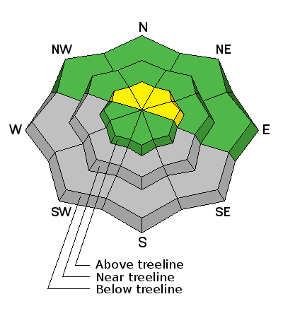
bottom line In the wind zone at and above treeline a MODERATE avalanche danger exists and human triggered avalanches are possible on steep, wind drifted slopes facing the north half of the compass. Remember- triggering even a small slide will expose stumps and rocks, instantly ruing your day and quite possibly your season. All other terrain offers a LOW avalanche danger.
|
 |
avalanche watch THIS AVALANCHE WATCH IS FOR THE WASATCH...BEAR RIVER AND WESTERN UINTA MOUNTAIN RANGES AND FOR THE NORTHWESTERN PORTIONS OF THE WASATCH PLATEAU. A WARM WINTER STORM WITH HEAVY SNOW AND STRONG WINDS WILL RAPIDLY INCREASE THE AVALANCHE DANGER BEGINNING TONIGHT AND CONTINUING THROUGH MONDAY. |
 |
special announcement We just released an exciting, new avy safety video designed specifically for snowmobilers - Knowledge is Powder. https://vimeo.com/113677686 NEW THIS YEAR: You can now receive advisories by email for each region in the state. Go here for details.
|
 |
current conditions Clouds streamed into the region overnight, ahead of an active weather pattern slated for the next couple of days. Currently, temperatures are in the low to mid 20's. Southwest winds bumped into the 20's and 30's overnight, but have calmed down and are currently blowing 10-20 mph. While average snow depths throughout the range remain relatively shallow, surprisingly good riding and turning conditions are found on a mostly supportable base, especially on low angle meadows and rock free slopes.
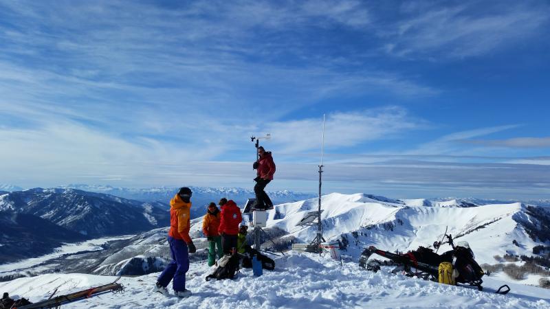
Pole dancing in the western Uinta's. Huge thanks to the Park City Powder Cats for their help yesterday installing the Windy Peak weather station. We are working through some communications issues, but hope to have everything on line shortly.
|
 |
recent activity
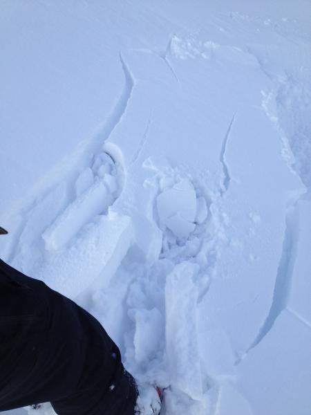
The surface snow is very weak. While manageable in depth and size, it doesn't take much to initiate new snow sluffs on steep slopes across the range. |
| type | aspect/elevation | characteristics |
|---|

|
|
LIKELIHOOD
 LIKELY
UNLIKELY
SIZE
 LARGE
SMALL
TREND
 INCREASING DANGER
SAME
DECREASING DANGER
|
|
description
There's plenty of light density snow to blow around and winds are expected to increase later today... it'll be a day of rising avalanche danger. As the storm develops and winds begin to ramp up, I suspect fresh drifts will break wider and deeper than you might expect. While mostly manageable this morning, by days end these fresh slabs will be packing a punch and you'll want to avoid any steep slope with recent deposits of wind drifted snow.
Whoomphing sounds or shooting cracks in front of your skis, board, or sled are huge clues to unstable snow.
|
 |
weather Today we can expect mostly cloudy skies with scattered snow showers. Temperatures climb into the upper 20's and low 30's. Tonight the main event rolls into the region and southwest winds begin cranking into the 50's and 60's along the high ridges. Snow develops and temperatures will be relatively warm and in the upper 20's. Sunday will be warm and windy with dense, heavy snow stacking up. Snow, with rain below about 8000 feet and strong winds continue Sunday night. A cold front lowers snow levels early Monday, but the snow turns showery and starts to taper off. Storm totals in the 12"-18" are a good bet by the time this system winds down. |
| general announcements Remember your information can save lives. If you see anything we should know about, please participate in the creation of our own community avalanche advisory by submitting snow and avalanche conditions. You can call me directly at 801-231-2170, email [email protected], or email by clicking HERE This is a great time of year to schedule a free avalanche awareness presentation for your group or club. You can contact me at 801-231-2170 or email [email protected] Donate to your favorite non-profit –The Utah Avalanche Center. The UAC depends on contributions from users like you to support our work. Benefit the Utah Avalanche Center when you buy or sell on ebay - set the Utah Avalanche Center as a favorite non-profit in your ebay account here and click on ebay gives when you buy or sell. You can choose to have your seller fees donated to the UAC, which doesn't cost you a penny. Utah Avalanche Center mobile app - Get your advisory on your iPhone along with great navigation and rescue tools. The information in this advisory is from the US Forest Service which is solely responsible for its content. This advisory describes general avalanche conditions and local variations always occur. I will update this advisory by 7:00 AM Sunday Dec. 21, 2014. |


_0.jpg)