| During the month of April, Mark Miller will donate $75 to the charity of your choice (5 to chose from, including the Utah Avalanche Center!) Mark Miller Subaru has raised over $300k in the previous 6 Do Good Feel Good events. More Info here |  |
| During the month of April, Mark Miller will donate $75 to the charity of your choice (5 to chose from, including the Utah Avalanche Center!) Mark Miller Subaru has raised over $300k in the previous 6 Do Good Feel Good events. More Info here | |
| Advisory: Uintas Area Mountains | Issued by Craig Gordon for Wednesday - January 1, 2014 - 6:15am |
|---|

|
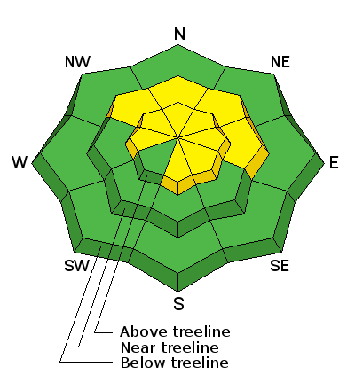
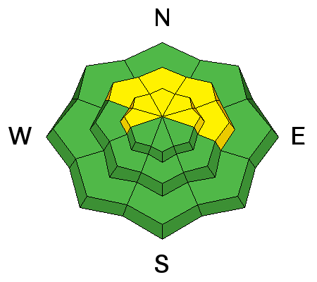
bottom line Terrain to avoid- steep, upper elevation slopes facing the north half of the compass, where a MODERATE avalanche danger is found and human triggered avalanches are possible. Once initiated, today's avalanches may break deeper and wider than you'd expect, creating an unmanageable and dangerous slide. A few fresh wind drifts developed overnight on upper elevation, leeward slopes and a MODERATE avalanche danger exists. While not widespread, human triggered avalanches are possible on steep, wind drifted slopes. If you're looking for LOW avalanche danger, head to wind sheltered terrain where there are no steep slopes above or adjacent to where you're riding.
|
 |
special announcement
Please join us at 7:00 on Monday Jan. 6th at Morgan Valley Polaris for a free avalanche awareness class for sledders... by sledders. Give the gift of STOKE! There are still a few slots open for our Avalanche and Riding Skills Workshop with Boondockers. Click here for more info. |
 |
current conditions Happy New Year! West winds blew the doors off of 2013 late last night, cranking in the 40's and 50's along the ridges with gusts to 60 mph near the highest peaks. They calmed down and switched to the northwest around 3:00 this morning and are currently blowing 25-35 mph. A weak storm slid through the region overnight, delivering an inch of snow. Temperatures currently sit in the mid 20's with teens at the highest elevations. Riding and turning conditions are a mixed bag, though recent reports indicate soft snow can still be found in wind sheltered mid elevation terrain. Click here for current winds, temperatures, and snowfall throughout the range. Click here for trip reports and avalanche observations.
|
 |
recent activity No new avalanche activity to report. |
| type | aspect/elevation | characteristics |
|---|

|
|
LIKELIHOOD
 LIKELY
UNLIKELY
SIZE
 LARGE
SMALL
TREND
 INCREASING DANGER
SAME
DECREASING DANGER
|
|
description
Man, the snowpack has gone from worse to... well, it's worser. The deterioration of our shallow snowpack really accelerated the past few days and in many places we're trenching to the dirt and riding on the ground. Not a good setup for whenever winter decides to return from its hiatus. In the meantime, the biggest avalanche concern is triggering a slide that breaks to old snow near the ground. Steep, rocky, upper elevation slopes facing the north half of the compass remain suspect and should be treated as guilty until proven otherwise. Given the shallow snowpack conditions right now, an avalanche that breaks to the ground will take you for a body beating ride through rocks and stumps barely hidden under this thin veil of snow.
|
| type | aspect/elevation | characteristics |
|---|

|
|
LIKELIHOOD
LIKELY
UNLIKELY
SIZE
 LARGE
SMALL
TREND
 INCREASING DANGER
SAME
DECREASING DANGER
|
|
description
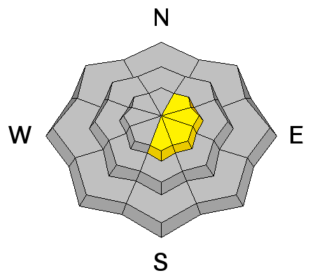
A few fresh drifts are found on steep leeward slopes, but these should be manageable in both size and depth. As always, think about the consequences of triggering even a small slide that could take you for an unexpected ride through trees or over a cliff band in steep, sustained terrain, quickly ruining your New Year. |
 |
weather Skies clear out this morning and it will be a beautiful day in the mountains. Winds are gonna be a nuisance this morning, but decrease throughout the day. Temperatures don't vary much from where we're at and then dip into the low teens and single digits overnight. Sunny and slightly warmer for Thursday. Clouds increase Friday with another weak storm slated for late in the week. There are no big, game changing storms in sight.
|
| general announcements Remember your information can save lives. If you see anything we should know about, please participate in the creation of our own community avalanche advisory by submitting snow and avalanche conditions. You can call me directly at 801-231-2170, email [email protected], or email by clicking HERE This is a great time of year to schedule a free avalanche awareness presentation for your group or club. You can contact me at 801-231-2170 or email [email protected] Donate to your favorite non-profit –The Utah Avalanche Center. The UAC depends on contributions from users like you to support our work. Benefit the Utah Avalanche Center when you buy or sell on ebay - set the Utah Avalanche Center as a favorite non-profit in your ebay account here and click on ebay gives when you buy or sell. You can choose to have your seller fees donated to the UAC, which doesn't cost you a penny. Utah Avalanche Center mobile app - Get your advisory on your iPhone along with great navigation and rescue tools. The information in this advisory is from the US Forest Service which is solely responsible for its content. This advisory describes general avalanche conditions and local variations always occur. I will update this advisory by 7:00 AM on Saturday Jan. 4, 2014 |


_0.jpg)