
| During the month of April, Mark Miller will donate $75 to the charity of your choice (5 to chose from, including the Utah Avalanche Center!) Mark Miller Subaru has raised over $300k in the previous 6 Do Good Feel Good events. More Info here |  |
| During the month of April, Mark Miller will donate $75 to the charity of your choice (5 to chose from, including the Utah Avalanche Center!) Mark Miller Subaru has raised over $300k in the previous 6 Do Good Feel Good events. More Info here | |
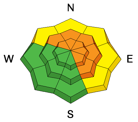
| Advisory: Skyline Area Mountains | Issued by Craig Gordon for Sunday - March 2, 2014 - 5:56am |
|---|


|
bottom line A CONSIDERABLE avalanche danger exists today on mid and upper elevation slopes in the wind zone along the summit. Human triggered avalanches are likely on steep, leeward slopes, especially those facing the north half of the compass. Fresh drifts have formed in low elevation terrain as well and a MODERATE danger exists. Human triggered avalanches are possible on steep slopes with recent deposits of wind drifted snow. Looking for LOW avalanche danger? Head to low angle wind sheltered terrain with no steep slopes above or adjacent to where you're riding.
|
 |
special announcement Join us March 8th and 9th at Brighton Resort for the first annual VertFest and 11th annual PowderKeg. There will be gear demos, a series of backcountry skills clinics, free beacon clinics, a party featuring the band Salem from Boulder, CO and a great gear raffle. The VertFest is a benefit for the Utah Avalanche Center. Click Here to find out more and to sign up for the backcountry clinics. Show Us You Know the Snow: US & Canadian avy groups have a challenge to sidecountry riders: Use your camera to tell a short video story about how your crew gets ready to safely ride beyond the resort boundary. Videos will be posted & promoted by GoPro & other partners. The contest will run till Mar 21. The winner will be determined by a combination of most views & an expert panel. Prizes include: 2 days at Monashee Powder Snowcats, 2 4-day Gold Passes to any US resort, a Backcountry Access Float 22 airbag, gear from Backcountry.com, editing help and support from Sherpas Cinema, & more. Winners will be announced in late March. . Details at knowthesnow.com Please share this with your friends |
 |
current conditions Yesterday's storm was a bit of a bust, remaining a little too far north to effect the Skyline. Just a few inches of snow fell yesterday and storm totals since Thursday night are close to a foot. West and southwest winds gusted into the 40's and 50's Saturday, but calmed down midday and are currently blowing northwest at 10-15 mph. Temperatures cooled into the mid 20's overnight. Riding and turning conditions are quite good on wind sheltered, shady slopes.
Even though we're about a month behind, the Skyline is filling in nicely. There's 130 cm total snow at Miller Flat Trailhead. |
 |
recent activity Here is the avalanche list that hardly covers a sliver of the terrain that avalanched over the last few weeks:
|
| type | aspect/elevation | characteristics |
|---|

|

|
LIKELIHOOD
 LIKELY
UNLIKELY
SIZE
 LARGE
SMALL
TREND
 INCREASING DANGER
SAME
DECREASING DANGER
|
|
description
Seems like nearly every slope on the Skyline avalanched in the big February cycle, but those that didn't still have the potential to break to weak snow near the ground. While many slopes are thick and strong, the snow structure remains questionable, especially in steep, rocky terrain facing the north half of the compass. Problem is... the surface snow feels strong and solid underneath us, but it's the bad mojo near the ground that's the big red flag. Strong snow over weak snow often suggests false green light conditions, allowing us to get well out onto the slope or put several sets of tracks on the hill before we find a weakness, collapse the slope, and now all bets are off. Once triggered, avalanches can break deep and wide, taking out the entire seasons snowpack. Best way to manage this situation is with terrain choices. Simply tone down your objectives the next few days and avoid being on or under steep leeward slopes. Slopes facing the south half of the compass and terrain that already avalanched big in February offer more predictable avalanche conditions.
|
| type | aspect/elevation | characteristics |
|---|

|
|
LIKELIHOOD
 LIKELY
UNLIKELY
SIZE
 LARGE
SMALL
TREND
 INCREASING DANGER
SAME
DECREASING DANGER
|
|
description
Yesterday's strong winds made up for lack of storm snow, forming fresh drifts in unusual locations and lower downslope than we usually see. Today's stout slabs may be a bit more stubborn, but will break deeper and wider than you might expect. They're packing a hefty punch and will quickly ruin your day, especially if you get slammed into trees or knocked over a cliff. In addition, once triggered, today's drifts have the possibility to break into weaker layers of snow, buried deeper in the snowpack. In either case, a seemingly benign situation can get quickly out of hand. As always, look for and avoid any fat, rounded pillow of snow, especially if it sounds hollow like a drum. |
| type | aspect/elevation | characteristics |
|---|

|

|
LIKELIHOOD
LIKELY
UNLIKELY
SIZE
 LARGE
SMALL
TREND
INCREASING DANGER
SAME
DECREASING DANGER
|
|
description
Cornices are huge and have the possibility to break back further than you might expect. |
 |
weather Hit or miss snow showers along with some breaks in cloud cover are on tap through midweek. During this period, west and southwest winds remain in the 10-20 mph range with a few gusts in the mid 20's and 30's along the high peaks. Temperatures climb into the 30's with overnight lows in the mid 20's. High pressure builds for Wednesday and then a better shot of snow Thursday night into early Friday. A warm, dry airmass is slated to move into the region for next weekend. |
| general announcements Donate to your favorite non-profit –The Utah Avalanche Center. The UAC depends on contributions from users like you to support our work. Benefit the Utah Avalanche Center when you buy or sell on ebay - set the Utah Avalanche Center as a favorite non-profit in your ebay account here and click on ebay gives when you buy or sell. You can choose to have your seller fees donated to the UAC, which doesn't cost you a penny. Utah Avalanche Center mobile app - Get your advisory on your iPhone along with great navigation and rescue tools. The information in this advisory is from the US Forest Service which is solely responsible for its content. This advisory describes general avalanche conditions and local variations always occur. This advisory will be updated by 7:00 AM Saturday, March 8th, 2014 or sooner if conditions warrant. |


.jpg)

