25th Annual Black Diamond Fall Fundraising Party
Thursday, September 13; 6:00-10:00 PM; Black Diamond Parking Lot
25th Annual Black Diamond Fall Fundraising Party
Thursday, September 13; 6:00-10:00 PM; Black Diamond Parking Lot
| Advisory: Salt Lake Area Mountains | Issued by Evelyn Lees for Saturday - March 10, 2018 - 6:04am |
|---|

|
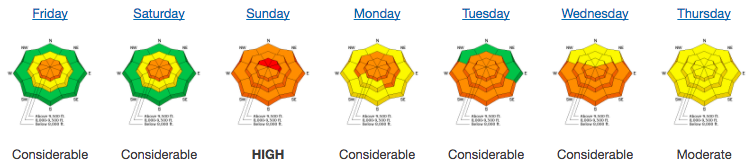
bottom line The avalanche danger is MODERATE for triggering a slab avalanche breaking into old faceted snow on slopes facing northwest through southeast at the mid and upper elevations. Large slab avalanches can be triggered in isolated areas. Warm temperatures and periods of sun may heat the snow enough that wet loose avalanches could be triggered at the low elevations and on steep, sunny slopes. Safer riding conditions can be on lower-angle northerly terrain with no steep slopes above. Roof-avalanches are occurring as snow slides off building roofs, with debris piles deep enough to bury and kill a person.
|
 |
special announcement We have discount lift tickets for Alta, Snowbird, Solitude, Snowbasin,and Powdermountain. Details and order information here. All proceeds from these go towards paying for avalanche forecasting and education!
|
 |
current conditions Under partly cloudy skies, temperatures are in the 20s at the mid elevations this morning and the northwesterly winds are light – 5 to 10 mph averages. If you’re heading to the highest alpine peaks – temperatures are currently in the mid teens, and winds averaging 20 to 30 mph, though expected to decrease later today. Soft dense powder is rarity…remaining only on northerly facing slopes at the mid and upper elevations. All other aspects are crusted, and may be slow to soften today. This past week snow and wind events that led to avalanching with skiers and snow-machiners getting caught. Fortunately, no significant injuries. Get caught up by reading our Week in Review from Friday March 2 through Thursday March 8.
|
 |
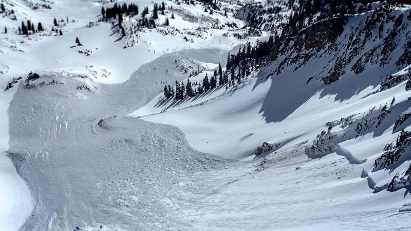
recent activity No new avalanches were reported yesterday, but spectacularly large and dangerous slides were triggered this week. Significant persistent slab activity from this week: - Mary Ellen Gulch - UPDATED REPORT - Control work on a wind-loaded east aspect at 11,000' in resulted in a large, complex avalanche with a crown up to 10'. Check out the video at the end. - Kessler Peak - UPDATES - in Big Cottonwood Canyon A large skier-triggered slide on an east aspect at 9700' on . The rider was carried 300' and fortunately emerged with no serious injuries. - Dresden Face - natural avalanche on southeast-facing in Hogum Fork failing in old snow. Looking down the Mary Ellen gulch slide - photo: Nat G.
Mark Staples and Trent Meisenheimer went to the Kessler avalanche on Thursday afternoon, and have an excellent accident write-up as well as video summary (pay particular attention to Mark's sage advice towards the end of the video): |
| type | aspect/elevation | characteristics |
|---|

|
|
LIKELIHOOD
 LIKELY
UNLIKELY
SIZE
 LARGE
SMALL
TREND
 INCREASING DANGER
SAME
DECREASING DANGER
|
|
description
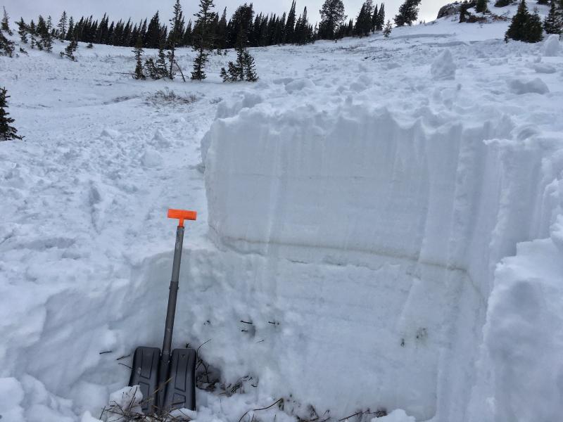
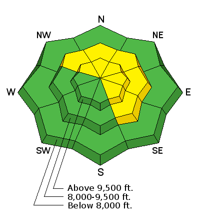
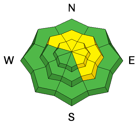
This year’s snowpack is like an old wooden cabin infested with termites. From the outside, it looks solid and it’s hard to tell that some beams are so riddled with termite tunnels they are weakened to the breaking point. Our snowpack is similar - many parts are strong and steep lines have been skied and ridden in the Salt Lake and Park City area mountains, even though there are buried weak layers. But in isolated places, the faceted layers are particularly weak and all it take is a small push by a person's weight or a smaller slide to trigger a large avalanche. Which slopes will slide is variable and unpredictable - complex terrain with break overs, shallow rocky spots, cliffs, changes in aspect and steepness are certainly suspect. Old tracks are not a definitive indication of stability. (For example, notice the tracks on the slope adjacent to Thursday's Kessler slide.) See the heat map for distribution by aspect and elevation of recent human triggered avalanches. How can this persistent slab hazard be handled? Terrain is your friend: enjoy the powder on low angle slopes with no overhead hazard. A common ingredient? A layer of faceted snow that formed in early February and is 4 to 8" below the prominent Feb 18 dust layer, now buried 2-3' down from the surface. Photo of the crown face from Thursday's Kessler avalanche. Note the prominent dust layer, and how the avalanche broke several inches below it.
|
| type | aspect/elevation | characteristics |
|---|

|
|
LIKELIHOOD
 LIKELY
UNLIKELY
SIZE
 LARGE
SMALL
TREND
 INCREASING DANGER
SAME
DECREASING DANGER
|
|
description
Wet Loose: Another day of warm temperatures and potential sun could heat the snow surface on low elevation slopes and on sunny slopes facing east through south through northwesterly. So if the sun comes out for a prolonged period where you are and the snow gets wet and sloppy, it’s time to get off of and out from under steep slopes. Roof-avalanches: Buildings are starting to shed their winter snow, so look up and avoid travel below steep roofs. Dave Richards photo:
Cornices have softened and are sensitive, often breaking back further than expected, on to what looks like flat terrain. So give them a wide berth and avoid travel below them. |
 |
weather A mild northwest flow will bring partly cloudy skies and warm temperatures to the mountains today. 9 and 10,000’ highs will be in the mid 30s to low 40s, and the northwesterly winds will be light at the mid elevations. The moderate winds at the upper elevations should diminish later today. This disappointing dry, warm weather will last through at least midweek. |
| general announcements CLICK HERE FOR MORE GENERAL INFO AND FAQ The UAC has new support programs with Outdoor Research and Darn Tough. Support the UAC through your daily shopping. When you shop at Smith's, or online at Outdoor Research, REI, Backcountry.com, Darn Tough, Patagonia, NRS, Amazon, eBay a portion of your purchase will be donated to the FUAC. See our Donate Page for more details on how you can support the UAC when you shop. Benefit the Utah Avalanche Center when you buy or sell on eBay - set the Utah Avalanche Center as a favorite non-profit in your eBay account here and click on eBay gives when you buy or sell. You can choose to have your seller fees donated to the UAC, which doesn't cost you a penny This information does not apply to developed ski areas or highways where avalanche control is normally done. This advisory is from the U.S.D.A. Forest Service, which is solely responsible for its content. This advisory describes general avalanche conditions and local variations always occur. |


 We Need Your Help With Social Media