| Please join us at the 23rd annual Black Diamond Fall Fundraiser Party Thursday Sept 15. Tickets are on sale now here, at the Black Diamond store & at REI. Special bonus raffle for online ticket purchasers! |
| Please join us at the 23rd annual Black Diamond Fall Fundraiser Party Thursday Sept 15. Tickets are on sale now here, at the Black Diamond store & at REI. Special bonus raffle for online ticket purchasers! |
| Advisory: Salt Lake Area Mountains | Issued by Drew Hardesty for Wednesday - March 23, 2016 - 6:21am |
|---|

|
bottom line It's time to back off. The danger is CONSIDERABLE on all wind drifted slopes where human triggered avalanches may be 2-3' deep in exposed terrain. The danger extends to the mid-elevation ridgelines and even mid-slope. Cracking and collapsing are immediate indicators to seek lower angle terrain. Drifts and cornices may run on approach. Remember, if you're heading out of bounds from the ski resorts, you are stepping into CONSIDERABLE DANGER. Your best bet will be to seek out mid-elevation, mid-canyon 30° slopes well below treeline. Ensure there's no steeper terrain above.
|
 |
special announcement Spring powder special! We have reduced the price of donated Snowbasin lift tickets to $50, half of window price. Take advantage of blower powder on a fat snowpack and benefit the Utah Avalanche Center at the same time. http://goo.gl/ZBG44W. Other donated tickets to Snowbird, Sundance, and Nordic Valley can be found HERE at reduced prices. Every penny on these donated tickets benefits the Utah Avalanche Center. |
 |
current conditions It appears that Old Man Winter was down but not out. Most areas picked up an additional 2-4" overnight. By the numbers:
Temperatures continue to bottom out and are in the low to mid teens. 11,000' temps are in the upper single digits. The northwest winds are a problem. They're all over the map. Many are blowing 15-20mph with gusts to 30/35. One 11,000' anemometer is showing hourly averages, however, in the 50s and 60s....which I might've been tempted to throw out but for a couple anemometers at 8300' and 9450' on the PC ridgeline showing hourly averages in the 25-30mph with gusts to 45 and 35mph with gusts to 48. Models suggest they'll diminish through the day and veer more northwest to northerly. While you're waiting for the winds to subside, take a look at our latest blog post - The Normalization of Deviants. If you wait a bit longer, you'd be following after The Wisdom of Elbert Despain.
|
 |
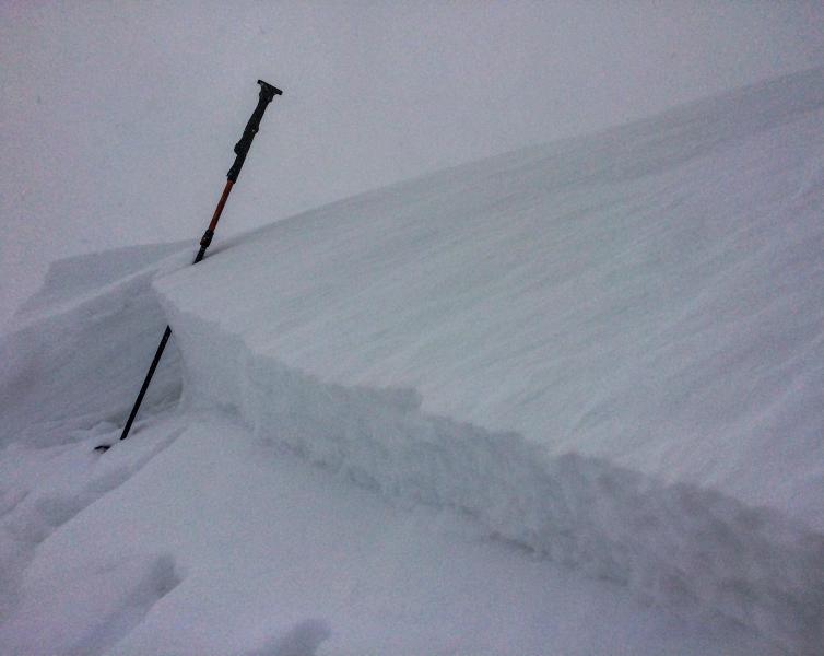
recent activity Yesterday's avalanche activity was confined to the new snow with longer running sluffs and wind drifts generally 8-12" deep that moved with provocation in steep wind loaded terrain. Mark White's photo of representative activity, below. For today, imagine wind slabs twice that size, if not more.
|
| type | aspect/elevation | characteristics |
|---|

|
|
LIKELIHOOD
 LIKELY
UNLIKELY
SIZE
 LARGE
SMALL
TREND
 INCREASING DANGER
SAME
DECREASING DANGER
|
|
description
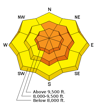
Don't be surprised to see a few wind drifts that have run naturally over the past couple of hours. Wind slabs will be sensitive to human provocation on steep drifted terrain and prominent on north to east to south facing slopes at the mid and upper elevations. They'll be cross-loaded into side gullies and even mid-slope. NOTE: Even mid-elevation ridgelines are showing moderate to strong northwest winds. Whereas the the drifts were generally small and manageable yesterday, they'll be significantly larger and less manageable today. |
| type | aspect/elevation | characteristics |
|---|

|
|
LIKELIHOOD
 LIKELY
UNLIKELY
SIZE
LARGE
SMALL
TREND
INCREASING DANGER
SAME
DECREASING DANGER
|
|
description
Cold, low density snow will continue to run fast and far, packing a punch today. Remember these start at a point and fan outwards and can entrain a fair bit of storm snow on the way down. These are likely to run farther than you might think. |
| type | aspect/elevation | characteristics |
|---|

|

|
LIKELIHOOD
LIKELY
UNLIKELY
SIZE
LARGE
SMALL
TREND
 INCREASING DANGER
SAME
DECREASING DANGER
|
|
description
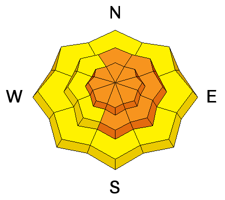
Cornices will have grown large overnight and may calve off upon approach. Give these cornices a wide berth and any ridge where the view is unobstructed. They may pull well back off from the ridgeline. |
 |
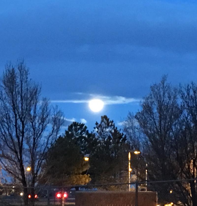
weather The storm is pulling away to the east but we might still be able to squeeze another couple inches out of a cold northwest flow this morning. This potential - as well as the moderate to strong northwest-becoming northerly winds should diminish (albeit slowly) - as the day wears on. Temps will be in the low teens. We'll see a bit of warming over the next couple days along with mostly cloudy skies. Another storm from the PacNW arrives Friday into early Saturday that may provide another 3-6" or so. Potential warming and clearing for later Sat/Sun with another large-scale system on tap for later Monday. If you hurry and there's just enough clearing, you might catch this morning's partial eclipse of the full moon...
|
| general announcements Remember your information can save lives. If you see anything we should know about, please help us out by submitting snow and avalanche conditions. You can also call us at 801-524-5304, email by clicking HERE, or include #utavy in your tweet or Instagram. To get help in an emergency (to request a rescue) in the Wasatch, call 911. Be prepared to give your GPS coordinates or the run name. Dispatchers have a copy of the Wasatch Backcountry Ski map. Backcountry Emergencies. It outlines your step-by-step method in the event of a winter backcountry incident. If you trigger an avalanche in the backcountry, but no one is hurt and you do not need assistance, please notify the nearest ski area dispatch to avoid a needless response by rescue teams. Thanks.
EMAIL ADVISORY If you would like to get the daily advisory by email you will need to subscribe here. DAWN PATROL Hotline updated daily by 5-530am - 888-999-4019 option 8. TWITTER Updates for your mobile phone - DETAILS UDOT canyon closures: LINK TO UDOT, or on Twitter, follow @UDOTavy, @CanyonAlerts or @AltaCentral Utah Avalanche Center mobile app - Get your advisory on your iPhone along with great navigation and rescue tools. Powderbird Helicopter Skiing - Blog/itinerary for the day Lost or Found something in the backcountry? - http://nolofo.com/ To those skinning uphill at resorts: it is critical to know the resort policy on uphill travel. You can see the uphill travel policy for each resort here. Benefit the Utah Avalanche Center when you shop from Backcountry.com or REI: Click this link for Backcountry.com or this link to REI, shop, and they will donate a percent of your purchase price to the UAC. Both offer free shipping (with some conditions) so this costs you nothing! Benefit the Utah Avalanche Center when you buy or sell on ebay - set the Utah Avalanche Center as a favorite non-profit in your ebay account here and click on ebay gives when you buy or sell. You can choose to have your seller fees donated to the UAC, which doesn't cost you a penny. This information does not apply to developed ski areas or highways where avalanche control is normally done. This advisory is from the U.S.D.A. Forest Service, which is solely responsible for its content. This advisory describes general avalanche conditions and local variations always exist. |