| Please join us at the 23rd annual Black Diamond Fall Fundraiser Party Thursday Sept 15. Tickets are on sale now here, at the Black Diamond store & at REI. Special bonus raffle for online ticket purchasers! |
| Please join us at the 23rd annual Black Diamond Fall Fundraiser Party Thursday Sept 15. Tickets are on sale now here, at the Black Diamond store & at REI. Special bonus raffle for online ticket purchasers! |
| Advisory: Salt Lake Area Mountains | Issued by Mark Staples for Friday - February 5, 2016 - 6:02am |
|---|

|
bottom line Today the overall avalanche danger is MODERATE, and there are heightened avalanche conditions on any slope with wind slabs or drifts from early this week or on any slope with a thin snowpack and/or buried layers of faceted snow. Unfortunately it takes work to know which slopes have these heightened avalanche conditions. There are several options if you want to get into avalanche terrain - do some investigating and careful assessments, go to low elevation slopes which have a LOW avalanche danger, or simply roll the dice. Another great option is to choose low angle slopes and not worry about avalanches at all.
|
 |
special announcement Tuesday February 9th - Fireside Chat at 7 p.m. at Black Diamond with UAC Forecaster Brett Kobernik who will discuss current conditions and discuss a near miss he had on Sunday when he was caught in an avalanche. For more info click HERE. Wednesday February 10th - Avalanche Clinic for Ice Climbers at 6 p.m. at Liberty Mountain. For more info click HERE.
|
 |
current conditions Upper Little Cottonwood Canyon is a catcher's mitt for snowfall with 12 inches of very light snow (0.6 inches of water) falling since yesterday. Most other places received 1-4 inches of new snow. Temperatures this morning are in the mid teens F. LIght winds are blowing 5-10 mph from the NW. Many wind sheltered slopes have about a foot of settled powder under the new snow from last night, and riding conditions are fantastic. With great snow, great coverage, and high pressure coming, now is a great time to get out. |
 |
recent activity We are saddened by the avalanche death of a backcountry skier who was killed Sunday, along the Park City ridge line. A preliminary report is HERE. We visited the site Wednesday and will have more information posted in coming days. Additionally one of our own staff members had a very close call on Wednesday and was caught in an avalanche. Preliminary info is posted HERE. |
| type | aspect/elevation | characteristics |
|---|

|
|
LIKELIHOOD
 LIKELY
UNLIKELY
SIZE
 LARGE
SMALL
TREND
 INCREASING DANGER
SAME
DECREASING DANGER
|
|
description
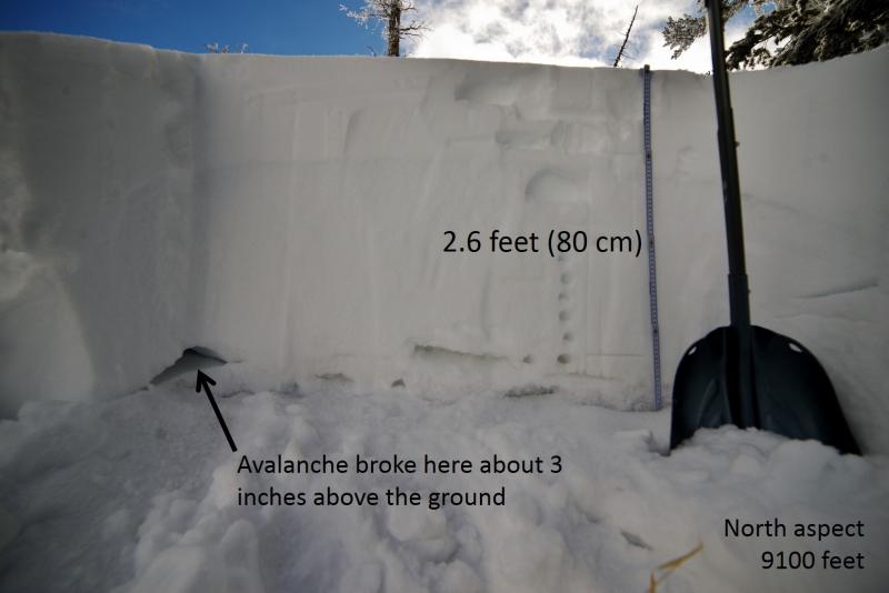
By far the most dangerous avalanche problem is deep slab and persistent slab avalanches breaking on buried facets. Recent avalanches tell us that this problem is lingering. We've only heard of a few deep slab avalanches in the last 7 days. Is this because the odds of triggering one have decreased or because most folks have been avoiding suspect slopes? We have to know what's under our feet or our track in order to make safe decisions. It's a free piece of data that takes only a few minutes to collect by pulling out your shovel and taking a look at the snowpack. Why ignore it? What to look for? In general you only need to dig about 3 feet deep. Watch for slopes with total snow depths less than about 3 feet. These slopes, especially if they face W through N through E, are likely ones that have avalanched one or more times this winter and may have very weak facets that can produce an avalanche. Photo below of the snowpack at the fatal avalanche from Sunday, January 31.
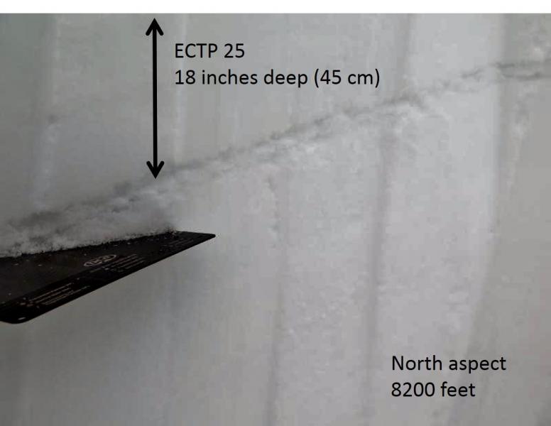
Ice crusts within the upper 2-3 feet may also have weak faceted snow above or below them. A skier found one of these layers yesterday near Mt. Aire between Mill Creek and Lambs Canyon that propagated fractures in Extended Column Tests. However, a skier in Little Cottonwood Canyon in Maybird Gulch found very deep snow, some of the strongest in the Wasatch. He did find some faceted layers in the upper part of the snowpack but these did not fracture in Extended Column Tests. These layers may not produce many avalanches and may heal soon, but I'd be looking for them for now. Photo -T. Falk
|
| type | aspect/elevation | characteristics |
|---|

|

|
LIKELIHOOD
LIKELY
UNLIKELY
SIZE
 LARGE
SMALL
TREND
 INCREASING DANGER
SAME
DECREASING DANGER
|
|
description
Winds this week have blown from most directions. Many wind slabs should be stubborn to trigger. Through most of this week, ski areas have triggered wind slabs with explosives and ski cuts. I think there are some in the backcountry that remain unstable. The best riding is in wind sheltered terrain, so it's an easy call to avoid any slopes with recent wind deposits. |
| type | aspect/elevation | characteristics |
|---|

|
|
LIKELIHOOD
LIKELY
UNLIKELY
SIZE
LARGE
SMALL
TREND
INCREASING DANGER
SAME
DECREASING DANGER
|
|
description
With a foot of light snow (5% density) in upper Little Cottonwood, expect loose dry snow slides. These should be predictable and not too dangerous. |
 |
weather Skies should be mostly cloudy today with some sunshine appearing later today. Temperatures should warm into the mid 20s F and winds should remain light. It looks like winds will increase tomorrow, and then a ridge of high pressure moves over the area for an extended period. |
general announcements
|