
| During the month of April, Mark Miller will donate $75 to the charity of your choice (5 to chose from, including the Utah Avalanche Center!) Mark Miller Subaru has raised over $300k in the previous 6 Do Good Feel Good events. More Info here |  |
| During the month of April, Mark Miller will donate $75 to the charity of your choice (5 to chose from, including the Utah Avalanche Center!) Mark Miller Subaru has raised over $300k in the previous 6 Do Good Feel Good events. More Info here | |
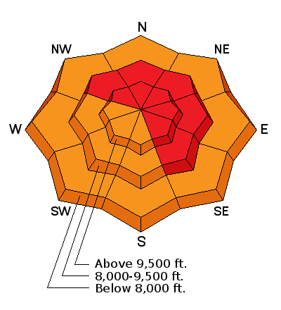
| Advisory: Salt Lake Area Mountains | Issued by Brett Kobernik for Monday - February 17, 2014 - 6:14am |
|---|

|
bottom line TODAY IS ACCIDENT WEATHER! Nice weather, CONTINUED DANGEROUS AVALANCHE CONDITIONS, and many people headed to the hills for the holiday - this is a classic combination for an avalanche accident. Continue to avoid being on or below all slopes of around 30 degrees in steepness or greater on all aspects and elevations.
|
 |
avalanche warning An Avalanche Warning remains in effect for all the mountains of northern and central Utah. Dangerous avalanche conditions exist on many aspects and elevations. Backcountry travelers should avoid slopes steeper than 30 degrees and all avalanche run out zones. |
 |
current conditions A cold front moved through mid day Sunday which laid down a quick 3 inches or so of high density snow containing lots of graupel. Temperatures dove into the teens afterward but have been on the rebound since midnight with most stations around 20 degrees currently. Strong westerly winds slowed a bit especially along the mid elevations. There are still moderate speeds along the higher elevations. Riding conditions should be improved even though it won't be the perfect powder we are used to. |
 |
recent activity The winds drifted quite a bit of snow on Sunday which created numerous small natural avalanches mostly just involving the wind transported snow. There was one natural avalanche that occurred early Sunday on a northeast facing slope at 8000 feet in elevation and ran 2000 feet vertical. It was in Provo Canyon near Arrowhead. It broke up to 6 feet deep and ran on weak faceted snow near the ground. DETAILS
|
| type | aspect/elevation | characteristics |
|---|

|
|
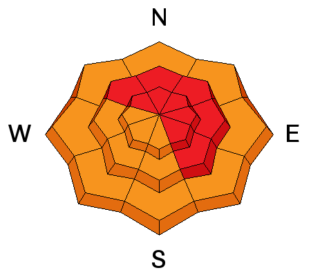
LIKELIHOOD
 LIKELY
UNLIKELY
SIZE
 LARGE
SMALL
TREND
 INCREASING DANGER
SAME
DECREASING DANGER
|
|
description
Naturals? Maybe not. Dangerous? You bet!!! It's not over. Don't mess with it. |
| type | aspect/elevation | characteristics |
|---|

|
|
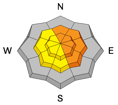
LIKELIHOOD
LIKELY
UNLIKELY
SIZE
 LARGE
SMALL
TREND
 INCREASING DANGER
SAME
DECREASING DANGER
|
|
description
Winds will increase during the day and will most likely drift snow creating sensitive new wind slabs. More importantly is that this wind drifted snow will enhance the chance of triggering a deep slab. |
| type | aspect/elevation | characteristics |
|---|

|
|
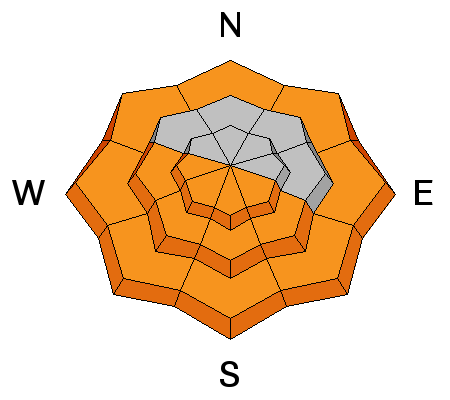
LIKELIHOOD
LIKELY
UNLIKELY
SIZE
 LARGE
SMALL
TREND
INCREASING DANGER
SAME
DECREASING DANGER
|
|
description
Yesterday's cool down should have helped this problem but temperatures are expected to be quite warm again today which will increase the chance of heat related avalanche activity again. |
 |
weather We'll see thin clouds with temperatures up into the mid to upper 30s at 8000 feet and around freezing on the higher ridges. West southwest winds will increase during the day into the moderate speed range with stronger gusts later. Tuesday looks fairly similar with slightly cooler temperatures. We have a couple of chances for snow as the week progresses. |
| general announcements Remember your information can save lives. If you see anything we should know about, please participate in the creation of our own community avalanche advisory by submitting snow and avalanche conditions. You can also call us at 801-524-5304 or 800-662-4140, email by clicking HERE, or include #utavy in your tweet or Instagram. If you trigger an avalanche in the backcountry - especially if you are adjacent to a ski area – please call the following teams to alert them to the slide and whether anyone is missing or not. Rescue teams can be exposed to significant hazard when responding to avalanches, and do not want to do so when unneeded. Thanks. Salt Lake and Park City – Alta Central (801-742-2033), Canyons Resort Dispatch (435-615-3322) Snowbasin Resort Dispatch (801-620-1017), Powder Mountain Dispatch (801-745-3772 x 123). Sundance Dispatch (801-223-4150) EMAIL ADVISORY We have switched to a new SLC email advisory system. If you would like to get the daily advisory by email, or if you have been getting the advisory by email since the beginning of the season and wish to continue, you will need to subscribe here. DAWN PATROL Hotline updated daily by 5-530am - 888-999-4019 option 8. Twitter Updates for your mobile phone - DETAILS UDOT canyon closures: LINK TO UDOT Utah Avalanche Center mobile app - Get your advisory on your iPhone along with great navigation and rescue tools.uned. Wasatch Powderbird Guides Blog/Itinerary for the Day. Lost or Found something in the backcountry? - http://nolofo.com/ Discount lift tickets are now available at Backcountry.com - Thanks to Ski Utah and the Utah Resorts. All proceeds go towards paying for Utah Avalanche Center avalanche and mountain weather advisories. To those skinning uphill at resorts: it is your responsibility to know the resort policy on uphill travel. Some allow uphill travel and have guidelines, some don't. Contact the Ski Patrol at each resort for details. IMPORTANT: Before skinning at a resort under new snow conditions, check in with Ski Patrol. Resorts can restrict or cut off access if incompatible with control and grooming operations. Benefit the Utah Avalanche Center when you shop from Backcountry.com or REI: Click this link for Backcountry.com or this link to REI, shop, and they will donate a percent of your purchase price to the UAC. Both offer free shipping (with some conditions) so this costs you nothing! Benefit the Utah Avalanche Center when you buy or sell on ebay - set the Utah Avalanche Center as a favorite non-profit in your ebay account here and click on ebay gives when you buy or sell. You can choose to have your seller fees donated to the UAC, which doesn't cost you a penny. This information does not apply to developed ski areas or highways where avalanche control is normally done. This advisory is from the U.S.D.A. Forest Service, which is solely responsible for its content. This advisory describes general avalanche conditions and local variations always exist. |


