
| During the month of April, Mark Miller will donate $75 to the charity of your choice (5 to chose from, including the Utah Avalanche Center!) Mark Miller Subaru has raised over $300k in the previous 6 Do Good Feel Good events. More Info here |  |
| During the month of April, Mark Miller will donate $75 to the charity of your choice (5 to chose from, including the Utah Avalanche Center!) Mark Miller Subaru has raised over $300k in the previous 6 Do Good Feel Good events. More Info here | |
| Advisory: Salt Lake Area Mountains | Issued by Evelyn Lees for Tuesday - February 4, 2014 - 6:43am |
|---|

|
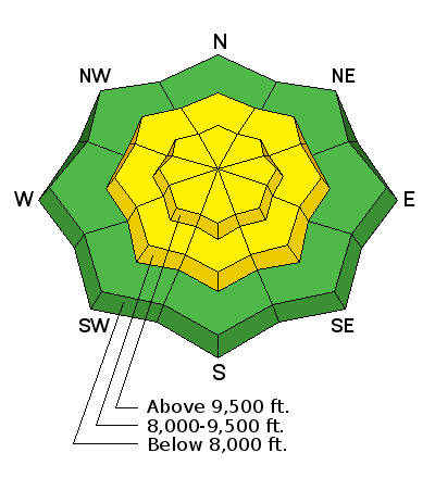
bottom line The avalanche danger is MODERATE on most mid and upper elevation slopes steeper than about 35 degrees. The chief concern is sensitive new wind drifts – avoid any steep slope that is wind drifted, and be alert for any increase in wind speed where you are, which will rapidly deepen these wind slabs. Substantial loose snow sluffs can be triggered – treat these with respect, and avoid being caught and carried. Lastly, there is still the isolated chance of triggering a deeper slab avalanche, mostly on north through east facing slopes at the upper elevations.
|
 |
special announcement 2 great learning opportunities this week: On Feb 6 (evening) and Feb 8 (field day) Brett Kobernik will be leading an Advanced Avalanche Skills class. This is your chance to spend time with a Forecaster honing your avalanche skills. This is a great follow-up to a backcountry 101 or refresher for a several year old Level 1 or Level 2 class. Details here. On Feb 6 (evening) and Feb 8 (field day), Craig Gordon will lead an avalanche class at Snowbasin for Sidecountry skiers and snowboarders. Learn how to make smart decisions riding in the backcountry on the other side of the resort boundary, riding powder and coming home alive. Details here. Join us Thursday 2/6 at the Wildflower Lounge at Snowbird at 6:00pm to hear ANDREW MCLEAN present: Powered Up – Kite Assisted Steep Skiing in Baffin Island and Patagonia The only thing better than remote, long, steep, powder-filled couloirs is getting a free ride to the base of them with a kite. Andrew will highlight two of his favorite kite assisted trips to Baffin Island and the Southern Patagonia Ice Cap. Andrew is the author of The Chuting Gallery and a prolific ski explorer who has completed first descents on all seven continents. |
 |
current conditions The overnight storm was a nice little refresher for the backcountry - the Ogden mountains received a 6 to 8 inch blanket of snow, Salt Lake and Park City mountains 3 to 6”, and the Provo mountains 1 to 3”. This snow may be fairly close to 2% “wild snow”, as it contained well under a ½ inch of water. The winds were suspiciously quiet all night, but are increasing as of 4 am. Most elevations have 5-10 mph averages from the northwest, but a few of the highest peaks now averaging 20 to 25 mph, gusting to 40. 10,000’ temperatures are in the low single digits. |
 |
recent activity Yesterday, there were reports of dry sluffs, and a few shallow natural wind slabs off east facing. The Ogden area mountains had more substantial wind slab activity – slabs up to 1 ½ feet deep released with slope cuts. |
| type | aspect/elevation | characteristics |
|---|

|
|
LIKELIHOOD
 LIKELY
UNLIKELY
SIZE
 LARGE
SMALL
TREND
 INCREASING DANGER
SAME
DECREASING DANGER
|
|
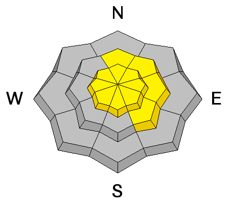
description
Today be very, very alert for any increase in wind speeds where you are – there is a lot of low density snow to blow around, and even light winds will quickly move the snow, drifting it in to very soft, but sensitive slabs. Watch for cracking in the snow, deepening drifts, and tracks filling in – all indications of wind slab formation – and avoid any steep slope with wind drifts. In addition, a few older wind drifts along the higher ridge lines could still be sensitive, and are now hidden beneath the new snow. |
| type | aspect/elevation | characteristics |
|---|

|
|
LIKELIHOOD
 LIKELY
UNLIKELY
SIZE
 LARGE
SMALL
TREND
 INCREASING DANGER
SAME
DECREASING DANGER
|
|
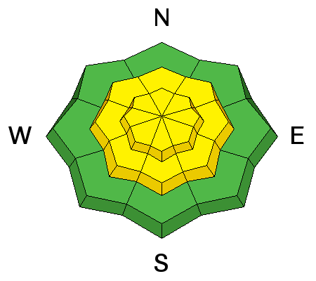
description
Dry loose sluffs could get pretty exciting today – and pack more of a punch than you think on continuously long, steep slopes. They will be able to entrain snow as they move down slope, and in places will be large enough to knock you off balance, take you for a ride and possibly bury you if the snow piles up in terrain trap such as a gully or on a bench. Any prolonged period of direct sun or an intense instability shower that rapidly drops several inches of snow could also trigger sluffs today. |
| type | aspect/elevation | characteristics |
|---|

|
|
LIKELIHOOD
 LIKELY
UNLIKELY
SIZE
LARGE
SMALL
TREND
INCREASING DANGER
SAME
DECREASING DANGER
|
|
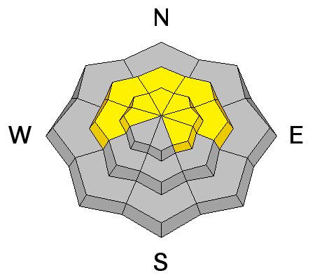
description
Finally, we still can’t lose focus on the layers the beneath all the new powder - there are a variety of crusts and facets, still not to be trusted, in spite of only erratic avalanches failing on these layers in the past week. Collapsing is a red flag for any of these weak layers, and slides can be triggered from a distance – below, to the side or above. |
 |
weather Skies are trying to clear from north to south, but they may lose the battle, with clouds filling back in and producing instability showers by mid-morning. Another with 2 to 4” of almost weightless snow is possible. 10,000’ temperatures will continue to cool – hovering around zero for the day. 8,000’ temperatures will remain near 10 degrees. The northwesterly winds are forecast to pick up slightly, with 10 to 20 mph averages. The highest peaks and ridge lines could reach 25 mph averages, with gusts to 35. Another storm is in the forecast, with the heaviest snow on Thursday. |
| general announcements Remember your information can save lives. If you see anything we should know about, please participate in the creation of our own community avalanche advisory by submitting snow and avalanche conditions. You can also call us at 801-524-5304 or 800-662-4140, email by clicking HERE, or include #utavy in your tweet or Instagram. If you trigger an avalanche in the backcountry - especially if you are adjacent to a ski area – please call the following teams to alert them to the slide and whether anyone is missing or not. Rescue teams can be exposed to significant hazard when responding to avalanches, and do not want to do so when unneeded. Thanks. Salt Lake and Park City – Alta Central (801-742-2033), Canyons Resort Dispatch (435-615-3322) Snowbasin Resort Dispatch (801-620-1017), Powder Mountain Dispatch (801-745-3772 x 123). Sundance Dispatch (801-223-4150) EMAIL ADVISORY We have switched to a new SLC email advisory system. If you would like to get the daily advisory by email, or if you have been getting the advisory by email since the beginning of the season and wish to continue, you will need to subscribe here. DAWN PATROL Hotline updated daily by 5-530am - 888-999-4019 option 8. Twitter Updates for your mobile phone - DETAILS UDOT canyon closures: LINK TO UDOT Utah Avalanche Center mobile app - Get your advisory on your iPhone along with great navigation and rescue tools.uned. Wasatch Powderbird Guides Blog/Itinerary for the Day. Lost or Found something in the backcountry? - http://nolofo.com/ Discount lift tickets are now available at Backcountry.com - Thanks to Ski Utah and the Utah Resorts. All proceeds go towards paying for Utah Avalanche Center avalanche and mountain weather advisories. To those skinning uphill at resorts: it is your responsibility to know the resort policy on uphill travel. Some allow uphill travel and have guidelines, some don't. Contact the Ski Patrol at each resort for details. IMPORTANT: Before skinning at a resort under new snow conditions, check in with Ski Patrol. Resorts can restrict or cut off access if incompatible with control and grooming operations. Benefit the Utah Avalanche Center when you shop from Backcountry.com or REI: Click this link for Backcountry.com or this link to REI, shop, and they will donate a percent of your purchase price to the UAC. Both offer free shipping (with some conditions) so this costs you nothing! Benefit the Utah Avalanche Center when you buy or sell on ebay - set the Utah Avalanche Center as a favorite non-profit in your ebay account here and click on ebay gives when you buy or sell. You can choose to have your seller fees donated to the UAC, which doesn't cost you a penny. This information does not apply to developed ski areas or highways where avalanche control is normally done. This advisory is from the U.S.D.A. Forest Service, which is solely responsible for its content. This advisory describes general avalanche conditions and local variations always exist. |


