| During the month of April, Mark Miller will donate $75 to the charity of your choice (5 to chose from, including the Utah Avalanche Center!) Mark Miller Subaru has raised over $300k in the previous 6 Do Good Feel Good events. More Info here |  |
| During the month of April, Mark Miller will donate $75 to the charity of your choice (5 to chose from, including the Utah Avalanche Center!) Mark Miller Subaru has raised over $300k in the previous 6 Do Good Feel Good events. More Info here | |
| Advisory: Salt Lake Area Mountains | Issued by Evelyn Lees for Monday - February 3, 2014 - 6:57am |
|---|

|
bottom line The avalanche danger is MODERATE on most mid and upper elevation slopes steeper than about 35 degrees. Avalanche problems are:
|
 |
special announcement 2 great learning opportunities this week: On Feb 6 (evening) and Feb 8 (field day) Brett Kobernik will be leading an Advanced Avalanche Skills class. This is your chance to spend time with a Forecaster honing your avalanche skills. This is a great followup to a backcountry 101 or refresher for a several year old Level 1 or Level 2 class. Details here. On Feb 6 (evening) and Feb 8 (field day), Craig Gordon will lead an avalanche class at Snowbasin for Sidecountry skiers and snowboarders. Learn how to make smart decisions riding in the backcountry on the other side of the resort boundary, riding powder and coming home alive. Details here. |
 |
current conditions Under clear skies, wintery temperatures are once again in the single digits this morning. The southwesterly winds were brisk for much of the night, but have decreased in the past few hours. Most stations are averaging less than 15 mph, though the 11,000’ ridge lines still have gusts in the 30s. Some of the steep, sunny slopes will be crusted, but widespread powder is the dominate, and appreciated, theme. |
 |
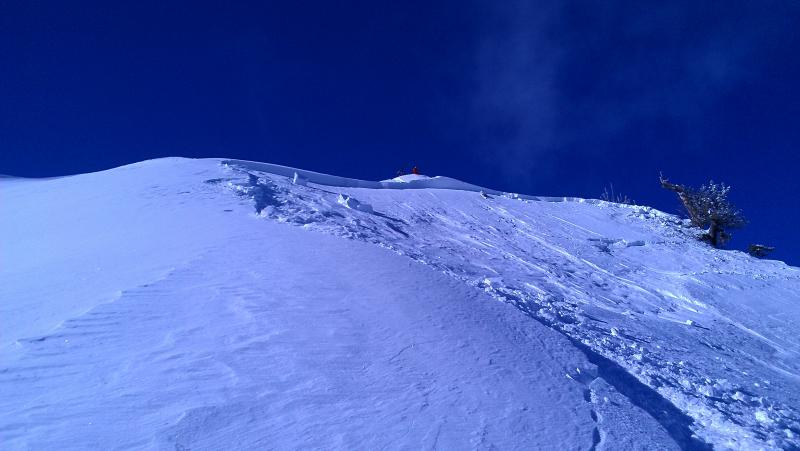
recent activity There was one significant avalanche yesterday – a hard slab remotely triggered off the Cascade Ridge line in the Provo area mountains, failing on a faceted weak layer. 10,000’, NE facing, 1-3 feet deep, with a step down section mid slope up to 5’ deep, Full observation HERE.
In addition, there were the numerous predicted dry and wet loose sluffs, both natural and human triggered, and very sensitive, easily triggered wind drifts in the afternoon when the winds picked up. |
| type | aspect/elevation | characteristics |
|---|

|
|
LIKELIHOOD
 LIKELY
UNLIKELY
SIZE
 LARGE
SMALL
TREND
 INCREASING DANGER
SAME
DECREASING DANGER
|
|
description
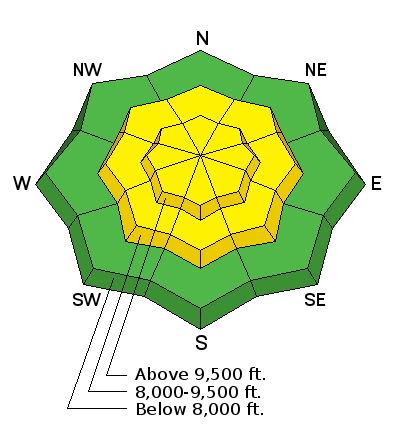
Yesterday afternoon, the southwesterly winds kicked up along the high ridges, rapidly blowing and drifting the low, low density snow around. This almost instantly created sensitive soft slabs, easy to trigger with slope cuts. These amplified southwesterly winds blew for much of the night, so the wind drifts today could be one to two feet deep and still easy to trigger. They will be mostly confined to the high ridges and upper elevation terrain, but in a few drainages, the winds did drift snow down into the mid elevations. Cracking of the snow on test slopes or where you are is a red flag that you are in an area of wind drifts. |
| type | aspect/elevation | characteristics |
|---|

|
|
LIKELIHOOD
 LIKELY
UNLIKELY
SIZE
LARGE
SMALL
TREND
INCREASING DANGER
SAME
DECREASING DANGER
|
|
description
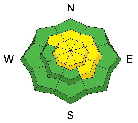
Yesterday’s Cascade Ridge avalanche is a huge red flag to me – that the multiple faceted weak layers are still not to be trusted, in spite of only erratic avalanches failing on these layers in the past week. The most likely layers a person would trigger are in the upper snowpack, about 1 to 3 feet deep, possibly associated with a crust. These are still easily accessible with quick hand pits and snow pits - look for a sugary weak facet layer or poor bonding around crusts. Collapsing is a red flag for any of these weak layers, and slides can be triggered remotely, from a distance – below, to the side or above. |
| type | aspect/elevation | characteristics |
|---|

|
|
LIKELIHOOD
LIKELY
UNLIKELY
SIZE
LARGE
SMALL
TREND
INCREASING DANGER
SAME
DECREASING DANGER
|
|
description
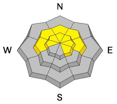
Both DRY and WET Loose Sluffs are possible again today.
|
 |
weather The will be a mix of clear skies and high thin clouds today ahead of the next cold front. The clouds will thicken by afternoon, and light snow is possible by dusk. 10,000’ temperatures will remain in the 5 to 10 degree range, with 8,000’ temperatures warming into the low 20s. The models forecast the southwesterly winds to be light, with speeds across the high ridges to be in the 10 to 20 mph range, with gusts 30 mph or less. The cold front should move through around midnight, with snow continuing into Tuesday. 8 to 12” of snow is possible, all very low density, with only about a ½ inch of water equivalent. Temperatures will drop to near zero behind the front. Another storm is in the forecast for Thursday night into Friday. |
| general announcements Remember your information can save lives. If you see anything we should know about, please participate in the creation of our own community avalanche advisory by submitting snow and avalanche conditions. You can also call us at 801-524-5304 or 800-662-4140, email by clicking HERE, or include #utavy in your tweet or Instagram. If you trigger an avalanche in the backcountry - especially if you are adjacent to a ski area – please call the following teams to alert them to the slide and whether anyone is missing or not. Rescue teams can be exposed to significant hazard when responding to avalanches, and do not want to do so when unneeded. Thanks. Salt Lake and Park City – Alta Central (801-742-2033), Canyons Resort Dispatch (435-615-3322) Snowbasin Resort Dispatch (801-620-1017), Powder Mountain Dispatch (801-745-3772 x 123). Sundance Dispatch (801-223-4150) EMAIL ADVISORY We have switched to a new SLC email advisory system. If you would like to get the daily advisory by email, or if you have been getting the advisory by email since the beginning of the season and wish to continue, you will need to subscribe here. DAWN PATROL Hotline updated daily by 5-530am - 888-999-4019 option 8. Twitter Updates for your mobile phone - DETAILS UDOT canyon closures: LINK TO UDOT Utah Avalanche Center mobile app - Get your advisory on your iPhone along with great navigation and rescue tools.uned. Wasatch Powderbird Guides Blog/Itinerary for the Day. Lost or Found something in the backcountry? - http://nolofo.com/ Discount lift tickets are now available at Backcountry.com - Thanks to Ski Utah and the Utah Resorts. All proceeds go towards paying for Utah Avalanche Center avalanche and mountain weather advisories. To those skinning uphill at resorts: it is your responsibility to know the resort policy on uphill travel. Some allow uphill travel and have guidelines, some don't. Contact the Ski Patrol at each resort for details. IMPORTANT: Before skinning at a resort under new snow conditions, check in with Ski Patrol. Resorts can restrict or cut off access if incompatible with control and grooming operations. Benefit the Utah Avalanche Center when you shop from Backcountry.com or REI: Click this link for Backcountry.com or this link to REI, shop, and they will donate a percent of your purchase price to the UAC. Both offer free shipping (with some conditions) so this costs you nothing! Benefit the Utah Avalanche Center when you buy or sell on ebay - set the Utah Avalanche Center as a favorite non-profit in your ebay account here and click on ebay gives when you buy or sell. You can choose to have your seller fees donated to the UAC, which doesn't cost you a penny. This information does not apply to developed ski areas or highways where avalanche control is normally done. This advisory is from the U.S.D.A. Forest Service, which is solely responsible for its content. This advisory describes general avalanche conditions and local variations always exist. |