| During the month of April, Mark Miller will donate $75 to the charity of your choice (5 to chose from, including the Utah Avalanche Center!) Mark Miller Subaru has raised over $300k in the previous 6 Do Good Feel Good events. More Info here |  |
| During the month of April, Mark Miller will donate $75 to the charity of your choice (5 to chose from, including the Utah Avalanche Center!) Mark Miller Subaru has raised over $300k in the previous 6 Do Good Feel Good events. More Info here | |
| Advisory: Salt Lake Area Mountains | Issued by Bruce Tremper for Saturday - February 1, 2014 - 5:29am |
|---|


|
bottom line An overall MODERATE danger exists in the backcountry today. Expect to find sluffs and occasional soft slabs within the new snow 6 inches to a foot deep. These will be mostly easy to trigger in steep terrain but generally smaller and softer. Also if the sun pokes through the clouds, the new snow can turn damp or wet in a hurry so watch for damp or wet sluffs in steep, sun exposed terrain.
|
 |
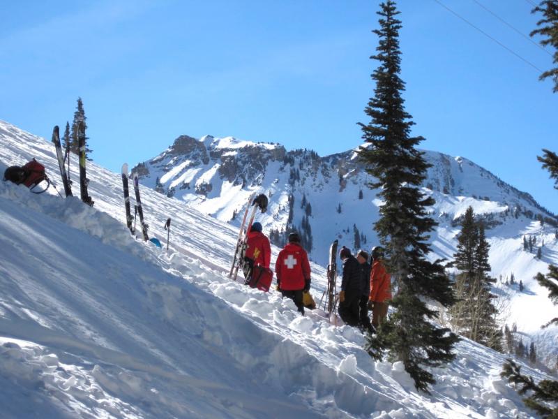
special announcement Special thanks to Snowbird, Alta and UDOT for hosting a successful National Avalanche School field session over the last few days. Avalanche professionals from around the country gathered for professional-level avalanche education.
|
 |
current conditions After a 3 week drought, yesterday hoards of people went out to enjoy up to a foot of low density powder. The deepest snow was in Little Cottonwood Canyon with about a foot of snow with 6-8 inches of settled snow outside of Little Cottonwood. The storm started out with dense snow or rain at the base and the storm quickly changed into very welcome, light and fluffy snow. Yesterday, temperatures remained chilly, in the low teens. This morning it's 7 degrees at 9,500' and expected to warm to perhaps 20 degrees. |
 |
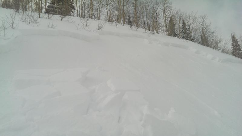
recent activity Yesterday the avalanche activity was mostly "manageable" sluffs and very soft slabs with a few of them barely enough to bury someone or do some damage. There was one remotely, skier-triggered slab in Sound of Music, an east facing slope in the backcountry near the Canyons Resort and another snowmobier-triggered slab on southeast facing Snake Creek south of Brighton. In addition, enough sun poked through the low clouds to make some damp sluffs on many of the steep, sun exposed slopes. But for the most part, the new snow was quite well-behaved.
Both dry and damp sluffs in Cardiff Fork;
Remotely-triggered soft slab near Canyons Resort. |
| type | aspect/elevation | characteristics |
|---|

|
|
LIKELIHOOD
 LIKELY
UNLIKELY
SIZE
 LARGE
SMALL
TREND
 INCREASING DANGER
SAME
DECREASING DANGER
|
|
description
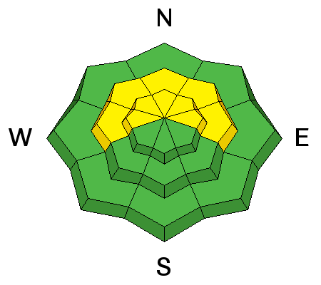
I will lump together new snow and persistent slabs here (see below for the nerdy distinction). In either case, you will see mostly "manageable" sluffs and occasional slabs within the new snow meaning that although they are easy to trigger, they are mostly soft and relatively small. But watch out as the new snow gains strength today and in the future because friendlier soft slabs can easily turn into more dangerous hard slabs. You will find trickier and more dangerous persistent slabs mostly on the sun and wind sheltered slopes such as mid elevation, northerly facing slopes. I posted a VIDEO from yesterday explaining the conditions. Storm snow vs persistent slab:
|
| type | aspect/elevation | characteristics |
|---|

|
|
LIKELIHOOD
 LIKELY
UNLIKELY
SIZE
LARGE
SMALL
TREND
INCREASING DANGER
SAME
DECREASING DANGER
|
|
description
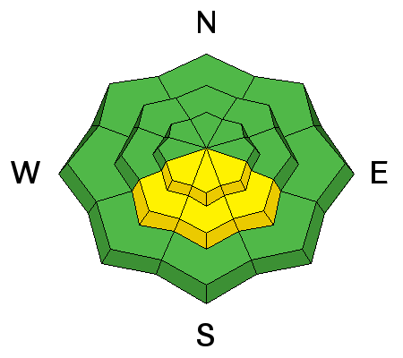
Yesterday, the sun poked through the low clouds enough in the afternoon to create some damp sluffs on the steep, southerly-facing slopes. It appears that the low level moisture is thicker today and we will most likely not see greenhousing from the sun like yesterday. But the sun is higher in the sky these days so it will not take much of it to turn our nice, dry snow into mank in a hurry. So keep a close eye on el Sol.
|
 |
weather With a weak system coming through from the north, we should have mostly cloudy skies with some light snow showers at times. The moisture is fairly shallow so the upper elevations may see the sun poke through at times. Temperatures will remain cold, rising from the single digits this morning to the upper teens by afternoon. Ridge top winds should be 10-15 mph from the north and northwest. Sunday should be clear to partly cloudy. The extended forecast calls for a welcome, steady series of disturbances from the west with one on Monday-Tuesday and another on Friday. |
| general announcements
Remember your information can save lives. If you see anything we should know about, please participate in the creation of our own community avalanche advisory by submitting snow and avalanche conditions. You can also call us at 801-524-5304 or 800-662-4140, email by clicking HERE, or include #utavy in your tweet or Instagram. If you trigger an avalanche in the backcountry - especially if you are adjacent to a ski area – please call the following teams to alert them to the slide and whether anyone is missing or not. Rescue teams can be exposed to significant hazard when responding to avalanches, and do not want to do so when unneeded. Thanks. Salt Lake and Park City – Alta Central (801-742-2033), Canyons Resort Dispatch (435-615-3322) Snowbasin Resort Dispatch (801-620-1017), Powder Mountain Dispatch (801-745-3772 x 123). Sundance Dispatch (801-223-4150) EMAIL ADVISORY We have switched to a new SLC email advisory system. If you would like to get the daily advisory by email, or if you have been getting the advisory by email since the beginning of the season and wish to continue, you will need to subscribe here. DAWN PATROL Hotline updated daily by 5-530am - 888-999-4019 option 8. Twitter Updates for your mobile phone - DETAILS UDOT canyon closures: LINK TO UDOT Utah Avalanche Center mobile app - Get your advisory on your iPhone along with great navigation and rescue tools.uned. Wasatch Powderbird Guides Blog/Itinerary for the Day. Lost or Found something in the backcountry? - http://nolofo.com/ Discount lift tickets are now available at Backcountry.com - Thanks to Ski Utah and the Utah Resorts. All proceeds go towards paying for Utah Avalanche Center avalanche and mountain weather advisories. To those skinning uphill at resorts: it is your responsibility to know the resort policy on uphill travel. Some allow uphill travel and have guidelines, some don't. Contact the Ski Patrol at each resort for details. IMPORTANT: Before skinning at a resort under new snow conditions, check in with Ski Patrol. Resorts can restrict or cut off access if incompatible with control and grooming operations. Benefit the Utah Avalanche Center when you shop from Backcountry.com or REI: Click this link for Backcountry.com or this link to REI, shop, and they will donate a percent of your purchase price to the UAC. Both offer free shipping (with some conditions) so this costs you nothing! Benefit the Utah Avalanche Center when you buy or sell on ebay - set the Utah Avalanche Center as a favorite non-profit in your ebay account here and click on ebay gives when you buy or sell. You can choose to have your seller fees donated to the UAC, which doesn't cost you a penny. This information does not apply to developed ski areas or highways where avalanche control is normally done. This advisory is from the U.S.D.A. Forest Service, which is solely responsible for its content. This advisory describes general avalanche conditions and local variations always exist. |