| During the month of April, Mark Miller will donate $75 to the charity of your choice (5 to chose from, including the Utah Avalanche Center!) Mark Miller Subaru has raised over $300k in the previous 6 Do Good Feel Good events. More Info here |  |
| During the month of April, Mark Miller will donate $75 to the charity of your choice (5 to chose from, including the Utah Avalanche Center!) Mark Miller Subaru has raised over $300k in the previous 6 Do Good Feel Good events. More Info here | |
| Advisory: Provo Area Mountains | Issued by Drew Hardesty for Monday - November 25, 2013 - 7:28am |
|---|

|
bottom line Pockets of MODERATE danger exist on steep, upper elevation northwest, north and northeasterly facing slopes, especially those with hard drifts of wind blown snow. While human triggered slides are unlikely, consequences remain severe. Collapsing and cracking into deeper layers are signs of localized instability. This avalanche advisory will cover both today and Tuesday with our next advisory Wednesday morning.
|
 |
special announcement Backcountry 101 for Snowshoers - REI, Cottonwood Canyons Foundation & the Utah Avalanche Center are teaming up to bring you Backcountry 101Dec 5 & 7, 2013 - We still have a few spots left. Go to our Education page here for more details - Grant Statham, a risk management specialist for Parks Canada, recently presented a TED talk on Risk. Grant's a long time climber and skier and delivers an excellent yet succinct presentation here in this 10 minute video. Check it out on our BLOG site. A couple top tier restaurants will be running specials next week in Salt Lake to benefit the Utah Avalanche Center - Grab a Bite and Support the UAC - Thanks
|
 |
current conditions It's a snowpack only a mother could love. With the the easterly wind event well in the rearview mirror (I won't even mention that southern Utah and the San Juans of Colorado picked up 2-3' of snow), Ma Nature added a bit of insult to injury with some green-housing in portions of the Wasatch. Subsequently, even some northerly facing terrain into the mid-elevations will have a thin temperature crust this morning. This morning, skies are clear, temps are in the mid 20s, and the northerly winds along the ridgelines hum at 20-30mph.
|
 |
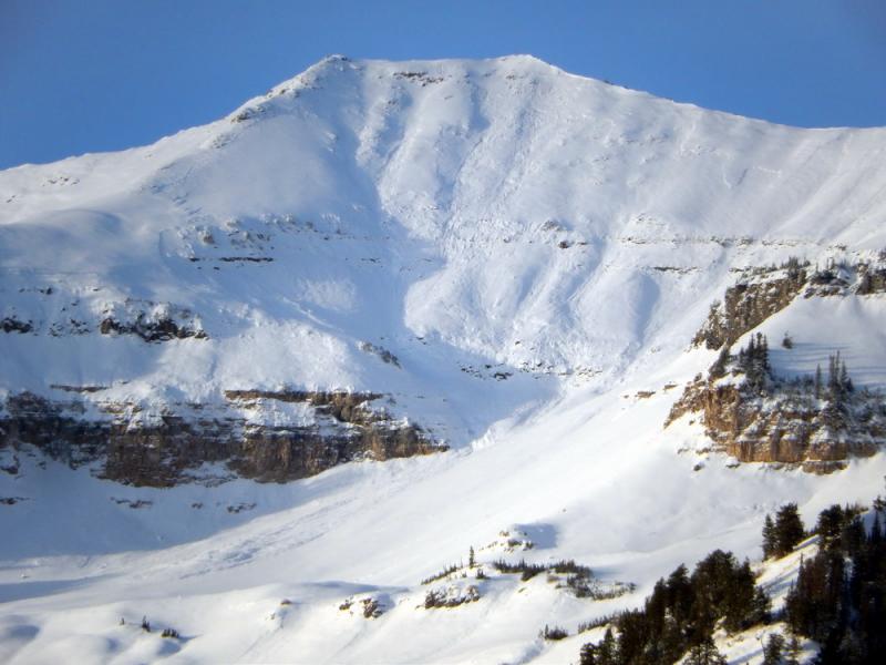
recent activity Our most recent observation from the Provo area mountains from Friday- and the Provo mountains went through a pretty good avalanche cycle on the 16th - photo below (UDOT forecaster Bill Nalli)
Our last significant human triggered avalanches in the central Wasatch backcountry came during and just after our last major snow storm. As one can see on our (sortable/searchable) Avalanche List, the last slides occurred on the 17th, a little more than a week ago. More recent slides into the older, weak snow from late October and early November were on the 22nd in the Logan area, the Skyline, and Western Uintas (as well as some with ski area control work), presumably catalyzed by the northeasterly wind event. Minor cracking and collapsing into the old snow continues to present itself every day, like that old cough that just won't go away.
This avalanche advisory will cover both today and Tuesday with our next advisory Wednesday morning. We will still post observations tonight and tomorrow on our ALL THE GOOD STUFF page under the header DETAILED INFO, in the menu above. |
| type | aspect/elevation | characteristics |
|---|

|

|
LIKELIHOOD
 LIKELY
UNLIKELY
SIZE
 LARGE
SMALL
TREND
 INCREASING DANGER
SAME
DECREASING DANGER
|
|
description
Old and tired wind drifts litter the mid and upper elevation landscape and, along with warming temps and natural settlement, will have started to bond and become less sensitive to provocation. You'll see them - they're smooth and rounded - sometimes hollow sounding. The drifts are in unusual places due to the strong easterly winds. Take care to avoid them still for another day. |
| type | aspect/elevation | characteristics |
|---|

|

|
LIKELIHOOD
LIKELY
UNLIKELY
SIZE
LARGE
SMALL
TREND
 INCREASING DANGER
SAME
DECREASING DANGER
|
|
description
Evelyn put it well yesterday describing the persistent slab problem. I'll leave it up for review. The structure remains the same, however stability is on the upswing. Full propagation stability tests and isolated cracking/collapsing are cause for caution; yet the likelihood of human triggering will be relegated to isolated and pockety terrain, above about 8800'-9000' in the northerly terrain. The persistent weak layer problem is going nowhere fast - the obnoxious loose, sugary facets near the ground are fairly widespread on northerly facing, upper elevation slopes. Where they have a slab of snow on top, especially a wind slab, it is still possible for a person to trigger a slide breaking near the ground. This would most likely be from a thinner spot, such as the edges of the slab or over thinly covered rocks. Slides can be triggered from a distance or or from below. Collapsing and cracking are warning signs of a bad slab/weak layer combo. |
 |
weather We'll remain under a mild and initially breezy northerly flow as a ridge of high pressure builds and amplifies off the coast. The ridge moves inland and comes overhead early this week and we'll have generally sunny skies, light wind and temps in the upper 20s and low 30s. By Thursday, a Pacific storm splits and dives south, kicking in clouds and perhaps a touch of precipitation into central and southern Utah Friday. The models hint at a change in the weather pattern starting Sunday or Monday with a series of storms on the way. |
| general announcements
If you trigger an avalanche in the backcountry - especially if you are adjacent to a ski area – please call the following teams to alert them to the slide and whether anyone is missing or not. Rescue teams can be exposed to significant hazard when responding to avalanches, and do not want to do so when unneeded. Thanks. Salt Lake and Park City – Alta Central (801-742-2033), Canyons Resort Dispatch (435-615-3322) Twitter Updates for your mobile phone - DETAILS UDOT canyon closures UDOT at (801) 975-4838 Get your advisory on your iPhone with the Utah Avalanche Center mobile app, along with great navigation and rescue tools. Wasatch Powderbird Guides Blog/Itinerary for the Day. They'll be up and running later this winter - Benefit the Utah Avalanche Center when you shop from Backcountry.com or REI: Click this link for Backcountry.com or this link to REI, shop, and they will donate a percent of your purchase price to the UAC. Both offer free shipping (with some conditions) so this costs you nothing! Benefit the Utah Avalanche Center when you buy or sell on ebay - set the Utah Avalanche Center as a favorite non-profit in your ebay account here and click on ebay gives when you buy or sell. You can choose to have your seller fees donated to the UAC, which doesn't cost you a penny. Remember your information can save lives. If you see anything we should know about, please participate in the creation of our own community avalanche advisory by submitting snow and avalanche conditions. You can also call us at 801-524-5304 or 800-662-4140, email by clicking HERE, or include #utavy in your tweet or Instagram. |


_3.jpg)