25th Annual Black Diamond Fall Fundraising Party
Thursday, September 13; 6:00-10:00 PM; Black Diamond Parking Lot
25th Annual Black Diamond Fall Fundraising Party
Thursday, September 13; 6:00-10:00 PM; Black Diamond Parking Lot
| Advisory: Ogden Area Mountains | Issued by Drew Hardesty for Sunday - February 4, 2018 - 7:18am |
|---|

|
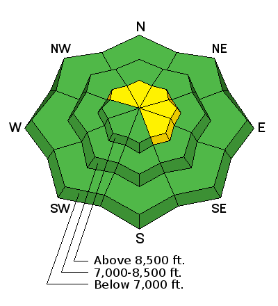
bottom line Most terrain has a LOW avalanche danger. Isolated areas of MODERATE danger, however, exist on northwest to east facing slopes above about 8500'. In this terrain, human triggered avalanches 1-2+' deep are possible. Additionally, shallow pockets of soft and hard wind slab are littered across the landscape, but most problematic in high consequence terrain. Lastly, damp push-alanches are possible in steep low to mid-elevation sheltered slopes that have remained warm for the past several days.
|
 |
special announcement The latest UAC podcast - "Recreating Like a Pro - A Conversation with IFMGA guide Anna Keeling" is live. This podcast will be ideal for anyone looking to pick up some tips and tricks from a professional mountain guide for recreating in the winter backcountry environment.
New blog post - Stacking the Deck - a Hindsight 20/40 story |
 |
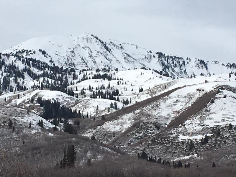
current conditions Skies vary from partly to mostly cloudy across the range. Mountain temperatures are in the mid to upper 30s. It's 45°F at our office at the National Weather Service. With this weather pattern, areas to our north are seeing all the snow while we get left holding the bag. The bag, in this case, also includes strong wind. The northwest winds are blowing 30-40, gusting to 50 with mid-elevation wind stations blowing 25, gusting to 40. Riding conditions are not for the faint of heart: corrugated sun crusts, trapdoor wind crust, sandboxing faceted snow, wafer thin rime. Snow depths are 25-35" along the Ogden skyline while areas east of the mountain valleys have 25-35". For coverage, see Paige and Kory's photos below. There is snow up high at least on N and E aspects.
|
 |
recent activity Minor damp push-alanches reported friday in steep terrain owing to the very warm temperatures and overcast skies. Recent snow and weather observations below - |
| type | aspect/elevation | characteristics |
|---|

|
|
LIKELIHOOD
 LIKELY
UNLIKELY
SIZE
 LARGE
SMALL
TREND
 INCREASING DANGER
SAME
DECREASING DANGER
|
|
description
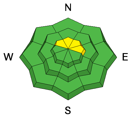
I was able to collapse and crack out a small test slope Friday on a north facing piece of terrain at 9200'. It cracked out about 1' deep and 20' across. It wasn't particularly representative of most of our terrain and yet there it was: poor structure, additional wind loading, trigger. Collapse. The moderate to strong winds will add just a bit of extra stress to areas of poor structure. Our lingering persistent slab avalanche problem exists at elevations 8500' and above, on slopes facing northwest through east (with a particular emphasis on north through northeast.) Thinner snowpack areas are particularly suspect. As an outlier, surface hoar formed on the 22nd and buried on the 25th has been noted in the mountains east of Hunstsville and Eden (and in the southern end of the Logan zone) and has yet to be reactive to human weight or snow tests. This is a layer of concern. Any collapsing or cracking in this layering is a red flag. It'll be important to watch this layer and see if additional wind loading may provide additional stress in localized terrain. |
| type | aspect/elevation | characteristics |
|---|

|
|
LIKELIHOOD
LIKELY
UNLIKELY
SIZE
 LARGE
SMALL
TREND
INCREASING DANGER
SAME
DECREASING DANGER
|
|
description
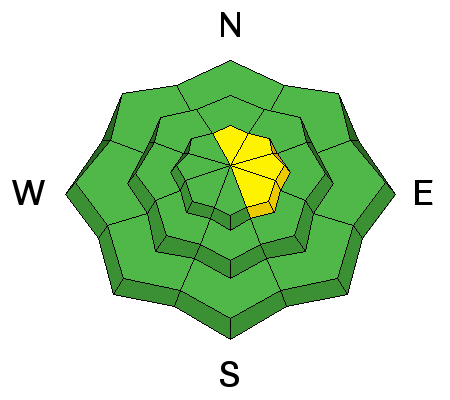
Little snow is available for transport due to the recent warm temps, but a few new wind slabs might form at the highest elevations, especially on northerly through easterly facing slopes. The drifts are likely sitting on dry snow and thin rime crusts and can be triggered by a person on steep slopes. Moderate to strong southwesterly winds are expected to continue throughout the day so keep an eye out for areas with consistent transport, especially near ridgelines. Avoid steep slopes with freshly wind drifted snow. |
 |
weather We should start to see some light precipitation this afternoon/early evening under the northwest flow. An initial rain/snow line may start as high as 8000', then drop to the valleys by Tuesday. Decent upper level support adds what it can to a generally weak system, but 2-5" seems reasonable with higher confidence for amounts north of I-80. Temps for today will be in the upper twenties along the upper ridgelines with northwest winds continuing to blow 30-35mph...increasing to 40mph tonight and tomrrow. |
| general announcements CLICK HERE FOR MORE GENERAL INFO AND FAQ The UAC has new support programs with Outdoor Research and Darn Tough. Support the UAC through your daily shopping. When you shop at Smith's, or online at Outdoor Research, REI, Backcountry.com, Darn Tough, Patagonia, NRS, Amazon, eBay a portion of your purchase will be donated to the FUAC. See our Donate Page for more details on how you can support the UAC when you shop. Benefit the Utah Avalanche Center when you buy or sell on eBay - set the Utah Avalanche Center as a favorite non-profit in your eBay account here and click on eBay gives when you buy or sell. You can choose to have your seller fees donated to the UAC, which doesn't cost you a penny This information does not apply to developed ski areas or highways where avalanche control is normally done. This advisory is from the U.S.D.A. Forest Service, which is solely responsible for its content. This advisory describes general avalanche conditions and local variations always occur. |