| Please join us at the 23rd annual Black Diamond Fall Fundraiser Party Thursday Sept 15. Tickets are on sale now here, at the Black Diamond store & at REI. Special bonus raffle for online ticket purchasers! |
| Please join us at the 23rd annual Black Diamond Fall Fundraiser Party Thursday Sept 15. Tickets are on sale now here, at the Black Diamond store & at REI. Special bonus raffle for online ticket purchasers! |
| Advisory: Ogden Area Mountains | Issued by Mark Staples for Sunday - January 17, 2016 - 7:37am |
|---|

|
bottom line Today with more snow and strong winds, the avalanche danger is HIGH on wind loaded, upper elevation slopes. A CONSIDERABLE avalanche danger exists on mid elevation slopes where a combination of wind loading or the presence of buried facets will create an avalanche. Below 7000 feet on low elevation slopes, there is less snow and less wind, but avalanches are still possible and the danger on these slopes is MODERATE.
|
 |
special announcement
|
 |
current conditions Since yesterday, 3-6 inches of snow fell containing 0.3-0.6 inches of water. Unfortunately, very strong winds began yesterday around 4 p.m. Last night and this morning, they were blowing westerly 15-20 mph and gusting 30-40 mph.This morning temperatures were in the mid to high 20s F. Total snowfall since Friday is about 15 inches with about 1.2 inches of water. Wind loaded slopes can easily have double this load. |
 |
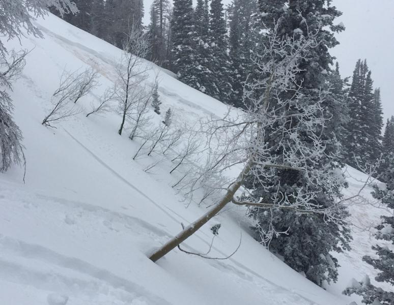
recent activity Yesterday afternoon as winds were increasing, ski patrols easily triggered soft slabs and fresh wind slabs. Skiers triggered an avalanche on a north facing slope at 8500 feet that was 20 inches deep and 100 feet wide north of I-80 on Lookout Peak. This slide broke at the ground and illustrates how weak the snowpack is in places where it is thin. In Big Cottonwood Canyon in Silver Fork, a group of skiers triggered an avalanche above the Meadow Chutes on a slope called the Football Field. This slope also had a thin and weak snowpack because it avalanched around Christmas. It is east facing at 9500 feet. Photo of slide on Lookout Peak (C. Eaves)
|
| type | aspect/elevation | characteristics |
|---|

|
|
LIKELIHOOD
 LIKELY
UNLIKELY
SIZE
 LARGE
SMALL
TREND
 INCREASING DANGER
SAME
DECREASING DANGER
|
|
description
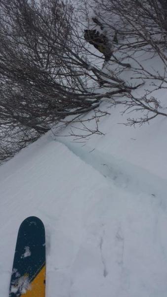
New snow and wind is an easy recipe that always creates avalanches. With up to 1.5 feet of new snow, winds have plenty of ammunition to form fresh wind slabs and drifts. People have reported wind slabs about 1 foot thick, but this morning they could be double that thickness. Winds have generally been westerly. For the most part, if you stay at lower elevations on slopes without wind drifted snow, you can avoid most (but not all – see next problem below) avalanches today. Photo of ski triggered wind slab about 12 inches deep on a east aspect on Ben Lomand Peak
|
| type | aspect/elevation | characteristics |
|---|

|
|
LIKELIHOOD
 LIKELY
UNLIKELY
SIZE
LARGE
SMALL
TREND
INCREASING DANGER
SAME
DECREASING DANGER
|
|
description
Knowing what’s under your feet or your track is critical if going into avalanche terrain today. Many slopes have buried facets stressed by the weight of recent snowfall. There are two different scenarios to watch for and avoid today. If it sounds confusing….that’s because it is. Consider avoiding avalanche terrain.
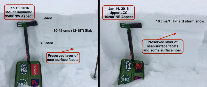
Photos from Thursday and Saturday showing the building slab (and increasing load) on buried facets that formed on the snow surface last week during clear, cold weather (G. Gagne).
|
 |
weather Winds will not continue blowing as strongly today as they did overnight. They should blow about 15-25 mph from the west at ridge tops. Cloudy skies should open and allow some sunshine today. Temperatures above 9000 feet should rise into the upper 20s F. |
| general announcements Remember your information can save lives. If you see anything we should know about, please participate in the creation of our own community avalanche advisory by submitting snow and avalanche conditions. You can also call us at 801-524-5304, email by clicking HERE, or include #utavy in your tweet or Instagram. To get help in an emergency (to launch a rescue) in the Wasatch, call 911. Be prepared to give your GPS coordinates or the run name. Dispatchers have a copy of the Wasatch Backcountry Ski map. Backcountry Emergencies. It outlines your step-by-step method in the event of a winter backcountry incident. If you trigger an avalanche in the backcountry, but no one is hurt and you do not need assistance, please notify the nearest ski area dispatch to avoid a needless response by rescue teams. Thanks. Salt Lake and Park City – Alta Central (801-742-2033), Canyons Resort/PCMR Dispatch (435)615-1911 Snowbasin Resort Dispatch (801-620-1017), Powder Mountain Dispatch (801-745-3772 x 123). Sundance Dispatch (801-223-4150) EMAIL ADVISORY If you would like to get the daily advisory by email you will need to subscribe here. DAWN PATROL Hotline updated daily by 5-530am - 888-999-4019 option 8. Twitter Updates for your mobile phone - DETAILS UDOT canyon closures: LINK TO UDOT, or on Twitter, follow @UDOTavy, @CanyonAlerts or @AltaCentral Utah Avalanche Center mobile app - Get your advisory on your iPhone along with great navigation and rescue tools. Powderbird Helicopter Skiing - Blog/itinerary for the day Lost or Found something in the backcountry? - http://nolofo.com/ To those skinning uphill at resorts: it is your responsibility to know the resort policy on uphill travel. You can see the uphill travel policy for each resort here. IMPORTANT: Before skinning or hiking at a resort under new snow conditions, check in with Ski Patrol. Resorts can restrict or cut off access if incompatible with control and grooming operations. Benefit the Utah Avalanche Center when you shop from Backcountry.com or REI: Click this link for Backcountry.com or this link to REI, shop, and they will donate a percent of your purchase price to the UAC. Both offer free shipping (with some conditions) so this costs you nothing! Benefit the Utah Avalanche Center when you buy or sell on ebay - set the Utah Avalanche Center as a favorite non-profit in your ebay account here and click on ebay gives when you buy or sell. You can choose to have your seller fees donated to the UAC, which doesn't cost you a penny. This information does not apply to developed ski areas or highways where avalanche control is normally done. This advisory is from the U.S.D.A. Forest Service, which is solely responsible for its content. This advisory describes general avalanche conditions and local variations always exist. |