| During the month of April, Mark Miller will donate $75 to the charity of your choice (5 to chose from, including the Utah Avalanche Center!) Mark Miller Subaru has raised over $300k in the previous 6 Do Good Feel Good events. More Info here |  |
| During the month of April, Mark Miller will donate $75 to the charity of your choice (5 to chose from, including the Utah Avalanche Center!) Mark Miller Subaru has raised over $300k in the previous 6 Do Good Feel Good events. More Info here | |
| Advisory: Ogden Area Mountains | Issued by Bruce Tremper for Friday - February 28, 2014 - 7:00am |
|---|

|
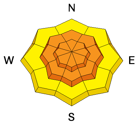
bottom line The overall avalanche danger is CONSIDERABLE (Level 3 / Orange) for sluffs and slabs within the new snow and for lingering wind slabs from yesterday as well as fresh wind slabs from expected strong winds later this afternoon and tonight. The next, much stronger, portion of this storm tonight and Saturday should push the avalanche danger to HIGH. I expect to issue an Avalanche Warning for tonight and Saturday for the mountains of northern and central Utah.
|
 |
avalanche watch THIS AVALANCHE WATCH IS FOR THE MOUNTAINS OF NORTHERN AND CENTRAL UTAH. HEAVY SNOW AND STRONG WIND WILL CREATE A HIGH AVALANCHE DANGER FRIDAY NIGHT AND SATURDAY. BACKCOUNTRY TRAVELERS SHOULD AVOID SLOPES STEEPER THAN 30 DEGREES AND AVOID AVALANCHE RUN OUT AREAS THIS WEEKEND. THIS WATCH DOES NOT INCLUDE SKI AREAS OR HIGHWAYS WHERE AVALANCHE CONTROL IS NORMALLY DONE. |
 |
special announcement Utah Department of Transportation will be conducting avalanche control operations in Little Cottonwood Canyon this morning and the road should reopen by around 8:00 am. Join us March 8th and 9th at Brighton Resort for the first annual VertFest and 11th annual PowderKeg. There will be gear demos, a series of backcountry skills clinics, free beacon clinics, a party featuring the band Salem from Boulder, CO and a great gear raffle. The VertFest is a benefit for the Utah Avalanche Center. Click Here to find out more and to sign up for the backcountry clinics. |
 |
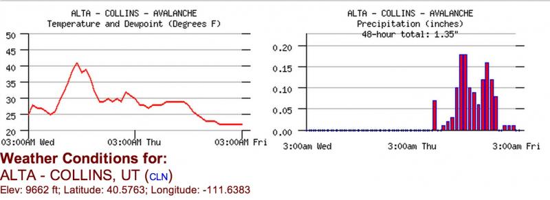
current conditions Most mountains of northern Utah got 10-12 inches of snow yesterday afternoon, which came down fast and furious. It started as rain to 7,000' making the new snow dense with graupel at the base and it became lighter during the day. It added up to a hefty 1.0 to 1.7 inches of water weight in most areas. The precipitation was fairly evenly distributed throughout northern Utah with lesser amounts in the Uinta Mountains with .7 to .9 inches of water weight. Luckily, most of the snow came down without a lot of wind except on the higher terrain. If you want powder, today is definitely the day to get out instead of the weekend and the earlier in the day the better. Tonight and Saturday we're expecting very strong wind at all elevations with an additional foot or more of new snow. It will be hard to even get into the mountains tomorrow because of the expected high avalanche danger.
By Rusty Milholland
A 2-day graph from Alta Collins weather station. |
 |
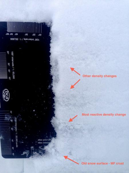
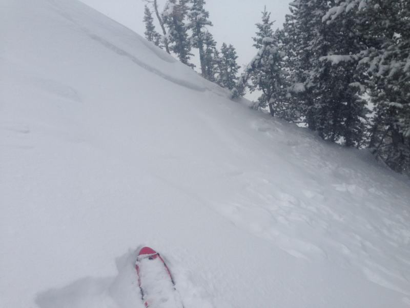
recent activity Yesterday with the high precipitation intensity, there was several density inversions and a couple graupel layers within the new snow, which created localized natural and human triggered, soft slabs up to about 8 inches deep. Rusty Millholland posted an excellent observation from upper Little Cottonwood Canyon yesterday afternoon. Ski resorts reported sluffs and shallow soft slabs within the new snow and some natural avalanches early last night with the wind and heavy snow.
Photo by Rusty Mllholland |
| type | aspect/elevation | characteristics |
|---|

|
|
LIKELIHOOD
 LIKELY
UNLIKELY
SIZE
 LARGE
SMALL
TREND
 INCREASING DANGER
SAME
DECREASING DANGER
|
|
description
The avalanche activity within the new snow reached its peak early last night with the high precipitation intensity and it will be ramping up again later this afternoon and especially tonight with increasing wind. So this morning should be the sweet spot to enjoy the powder. After that, it may be hard to even get up the canyons, much less into the backcountry because of the expected high avalanche danger. Still, today you will likely find sluffs and soft slab avalanches up to a foot deep on many of the steep slopes but the riding should be fast and fun on the gentler terrain, so there's no reason to push the slope angles today. I'm calling it a Level 3 / Orange / Considerable danger today, which means Experts Only or Elevated Caution. This means you will not only need to carefully read the avalanche terrain but you will also need to carefully test how well the new snow is bonded by jumping on small test slopes and regularly dig down with your hand to test the layers as you travel. The pre-exising snow is fairly stable in the central Wasatch so I'm not expecting any of the new snow avalanches to step down into deeper weak layers today but they could do so by Saturday. Remember if you're headed into the Uinta Mountains today, they are a notch higher on the danger scale. Be sure to check their advisory. |
| type | aspect/elevation | characteristics |
|---|

|
|
LIKELIHOOD
 LIKELY
UNLIKELY
SIZE
LARGE
SMALL
TREND
 INCREASING DANGER
SAME
DECREASING DANGER
|
|
description
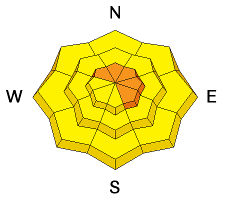
Late yesterday afternoon, the wind blew fairly hard at times from the west and southwest but mostly at higher elevations. Then, the wind will blow hard later this afternoon and especially overnight, again from the southwest to west. Tonight's wind should blow 50, gusting to 80 along the high peaks and get into mid and lower elevation terrain late afternoon and overnight. So today, I would expect you could find some lingering wind slabs from yesterday in the upper elevation wind exposed terrain and by late afternoon we will have some fresh wind slabs developing at all elevations. As always, avoid steep slopes with recent wind deposits, which usually look smooth and rounded. They usually feel slabby and sometimes sound hollow. |
 |
weather This morning should be the lull in the series of storms before the big wallop tonight and Saturday with strong wind and heavy snow. So get out and enjoy it while you can. The wind should be moderate this morning from the southwest, blowing 20, gusting to 40 on the peaks and half that amount on most ridges. Temperatures should rise to just under freezing. Skies should be partly to mostly cloudy today with the possibility of light snow, especially late in the day. Tonight, the winds will pick up and blow hard, reaching their maximum early Saturday morning 40, gusting to 80 on the upper elevation terrain and the wind should get into the lower elevations as well. We're expecting another foot or more of dense snow overnight into Saturday with the rain-snow line rising to around 8,000' overnight then sinking back down to the bottom of the canyon by Saturday morning. Snow should end by Saturday night. Sunday looks like a rest day to dig out and do some avalanche viewing but the skies should remain cloudy with light snow showers lingering. |
| general announcements
Remember your information can save lives. If you see anything we should know about, please participate in the creation of our own community avalanche advisory by submitting snow and avalanche conditions. You can also call us at 801-524-5304 or 800-662-4140, email by clicking HERE, or include #utavy in your tweet or Instagram. If you trigger an avalanche in the backcountry - especially if you are adjacent to a ski area – please call the following teams to alert them to the slide and whether anyone is missing or not. Rescue teams can be exposed to significant hazard when responding to avalanches, and do not want to do so when unneeded. Thanks. Salt Lake and Park City – Alta Central (801-742-2033), Canyons Resort Dispatch (435-615-3322) Snowbasin Resort Dispatch (801-620-1017), Powder Mountain Dispatch (801-745-3772 x 123). Sundance Dispatch (801-223-4150) EMAIL ADVISORY We have switched to a new SLC email advisory system. If you would like to get the daily advisory by email, or if you have been getting the advisory by email since the beginning of the season and wish to continue, you will need to subscribe here. DAWN PATROL Hotline updated daily by 5-530am - 888-999-4019 option 8. Twitter Updates for your mobile phone - DETAILS UDOT canyon closures: LINK TO UDOT Utah Avalanche Center mobile app - Get your advisory on your iPhone along with great navigation and rescue tools.uned. Wasatch Powderbird Guides Blog/Itinerary for the Day. Lost or Found something in the backcountry? - http://nolofo.com/ Discount lift tickets are now available at Backcountry.com - Thanks to Ski Utah and the Utah Resorts. All proceeds go towards paying for Utah Avalanche Center avalanche and mountain weather advisories. To those skinning uphill at resorts: it is your responsibility to know the resort policy on uphill travel. Some allow uphill travel and have guidelines, some don't. Contact the Ski Patrol at each resort for details. IMPORTANT: Before skinning at a resort under new snow conditions, check in with Ski Patrol. Resorts can restrict or cut off access if incompatible with control and grooming operations. Benefit the Utah Avalanche Center when you shop from Backcountry.com or REI: Click this link for Backcountry.com or this link to REI, shop, and they will donate a percent of your purchase price to the UAC. Both offer free shipping (with some conditions) so this costs you nothing! Benefit the Utah Avalanche Center when you buy or sell on ebay - set the Utah Avalanche Center as a favorite non-profit in your ebay account here and click on ebay gives when you buy or sell. You can choose to have your seller fees donated to the UAC, which doesn't cost you a penny. This information does not apply to developed ski areas or highways where avalanche control is normally done. This advisory is from the U.S.D.A. Forest Service, which is solely responsible for its content. This advisory describes general avalanche conditions and local variations always exist. |


_4.jpg)