31st Annual Backcountry Benefit - September 12th - Tickets Available Here!

Observation: Grizzly Gulch

Observation Date
2/27/2014
Observer Name
Rusty Milholland
Region
Salt Lake » Little Cottonwood Canyon » Grizzly Gulch
Location Name or Route
Upper Little Cottonwood
Weather
Sky
Obscured
Precipitation
Moderate Snowfall
Wind Direction
West
Wind Speed
Moderate
Weather Comments
Looked like winter, felt like spring.
Snow Characteristics
New Snow Depth
7"
New Snow Density
Medium
Snow Surface Conditions
Powder
Snow Characteristics Comments
Great "dust-on-crust" skiing where you didn't hit old tracks.
Red Flags
Red Flags
Heavy Snowfall
Wind Loading
Cracking
Red Flags Comments
Depth hoar lurking in the depths, out of sight but not quite out of mind even in the upper cottonwoods. Didn't check the box as I didn't observe the poor structure today...
Avalanche Problem #1
Problem
New Snow
Trend
Increasing Danger
Problem #1 Comments
Expected to see poor bonding between the new/old snow interface. Instead, new snow came in wet and dense with temps nearing 30 degrees at the Alta-Collins site. As temps cooled, several instabilities have developed as a result of in density changes within the new snow (see photo 1). Shovel tilt tests and test slopes have shown the lower most density change to be reactive on all aspects, especially in wind affected terrain. Triggered and witnessed several small R1-D1 soft slabs about 4 inches down on the lowest density change. I'm interested to see if this layer is still as reactive tomorrow morning, especially if we get any more snow.
Avalanche Problem #2
Problem
Persistent Weak Layer
Trend
Increasing Danger
Problem #2 Comments
Snow was coming down with light to moderate winds in Upper LCC this afternoon. Small drifts and slabs forming on lee features. Wind affected (both windward and leeward) snow was more reactive on today's density change as the thin slab had slightly more cohesion. Wind speeds have picked up a little since sundown and since much of this afternoon's snow came down quite light, I would expect to see loading in the usual spots tomorrow morning.
Comments
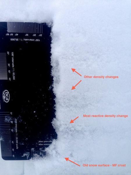
Photo 1 - Density changes within today's new snow. 
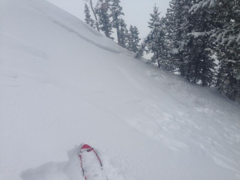
Photo 2 - Human triggered SS-R1-D1 pocket just off a ridge in a windward concavity.
Today's Observed Danger Rating
Moderate
Tomorrows Estimated Danger Rating
Moderate